Sold2023MAP, Eastern US, BowenColonial Eastern United States. Emanuel Bowen, A Map of the British American Plantations, Extending from Boston in New England to Georgia; Including All the Back Settlements in the Respective ProvinceSee Sold Price
Sold2017William Faden 1796 Map Eastern US, North AmericaFaden, William (BRITISH, 1749-1836); Map of the Eastern United States, North American with British Territories and Those of Spain according to the Treaty of 1784 (from a larger atlas), 1796; handcolorSee Sold Price
Sold2021MAP, Eastern US, Phelps & EnsignEastern United States. Phelps & Ensign, Phelps & Ensign's Travellers' Guide, and Map of the United States, Containing the Roads, Distances, Steam Boat and Canal Routes &c., 1842 (dated). Hand Color. TSee Sold Price
Sold2019MAP - Eastern US. AnonymousColonial Eastern United States. Anonymous, An Accurate Map of the English Colonies in North America Bordering on the River Ohio, 1754 (published). Hand Color. This unusual map of the colonies spans frSee Sold Price
Sold2020Eastern US Road MapTitle/ Content of Map:Eastern US Road Map Date Printed: 1971 Cartographer: American Automobile Association Material/Medium: paper Dimensions: 30-fold. approx. 28x37.5 inches open, 4x6.5 inches folded.See Sold Price
Sold2023Framed Engraved Map of Eastern US by E. Jones 1805Featured in this lot is this original 1805 E. Jones engraved map showing the United States from Maine to Georgia (Florida is cut off) and west to the Mississippi. The map was engraved by E. Jones, andSee Sold Price
Sold2018Marmocchi: Scarce Italian Map of Eastern U.S. in 1858Map: Stati Orientali della Unione Americana Cartographer: F.C. Marmocchi Place/Date: Milan / 1858 Size: 13 3/8" x 11" Condition: outline wash color; overall age toning An interesting and scarce 19th-cSee Sold Price
Sold2021WILLIAM MACKENZIE Map of Eastern US LithographWILLIAM MACKENZIE Map of Eastern US Lithograph, inscriptions read ‘Eastern Division of the United States’, ‘William Mackenzie London Edinburgh & Glasglow’, subject the eastern United States, mSee Sold Price
Sold2017Emanuel Bowen, map Eastern SeaboardEmanuel Bowen, map Eastern Seaboard, Emanuel Bowen (British, 1694-1767), "A New and Accurate Map of New Jersey, Pennsylvania, New York, and New England", c. 1744, from Maryland to Nova Scotia, hand-coSee Sold Price
Sold20191846 Kemble Map of Central and Eastern US DuringReserve Reduced! Map Title/Content: 1846 Kemble Map of Central and Eastern US During French, English and Spanish Colonial Period -- Map of the French, English & Spanish Possessions in North America inSee Sold Price
Sold20241887 National GAR Encampment Handbook21st National GAR Encampment of 1887 in St. Louis handbook. Handbook was sponsored by the Illinois Central Railroad. The handbook has a map of Eastern half of U.S. with the railroad showing illustrateSee Sold Price
Sold2022Emanuel Bowen Map USA Eastern Seaboard 1740s New YorkEmanuel Bowen, map of United States Eastern Seaboard, Emanuel Bowen (British, 1694-1767), "A New and Accurate Map of New Jersey, Pennsylvania, New York, and New England", c. 1744, from Maryland to NovSee Sold Price
Sold2022VINTAGE NORTH EASTERN US & FRENCH ROAD MAPSVINTAGE NORTH EASTERN US & FRENCH ROAD MAPS Road maps of the eastern seaboard of PA, NY, D.C., VA, MD, and NJ by AAA and Exxon. Also included are five Michelin maps of France.See Sold Price
Sold20201817 Life of Washington Weems Penna German Ed"Parson" Weems. Das Leben Georg Waschington. Baltimore 1817. Folding map at front of the eastern US. Frontis engraving and six other plates. 8vo, 240 p. Corner of one page torn away. Full leather. ConSee Sold Price
Sold20201873 Lloyd Map of Parts of Eastern and Midwestern US --Title/Content of Map: 1873 Lloyd Map of Parts of Eastern and Midwestern US -- County Map of New York, New Jersey, Pennsylvania, Ohio, Deleware, Maryland, Virginia, West Virginia, Province of Ontario CSee Sold Price
Sold2018Framed Antique U.S. MapsFramed Antique Maps of U.S. and Eastern United States. To 23" x 18".See Sold Price
Sold2020Grp: Books on the Eastern U.S.Group of books and maps on the Eastern United States. Includes The John Henry County Map of Virginia 1770 by Louis B. Wright (two copies); Tidewater Towns: City Planning in Colonial Virginia and MarylSee Sold Price
Sold2024U.S. War Office 1944 map of Eastern FranceU.S. War Office 1944 map of Eastern France Overall: 22 5/8"h x 23 1/8"wSee Sold Price
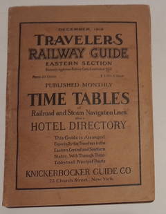
Sold20241915 Traveler's Guide Eastern US. A 344 page bookA 5 3/4" by 8" soft cover book with railroad timetables and other travel information: hotel ads, city, state maps, etc. Paper is supple and not pulpy.See Sold Price
Sold2016George Cram: Map of Eastern Part of Quebec, 1891Map: Eastern Part of Quebec Maker: George Cram Date: 1891 Size: 13.5 x 21.75 inches For "The Home Knowledge Atlas" George F. Cram (1842-1928) served in the U.S. Army during the American Civil War. AftSee Sold Price
Sold2021(CIVIL WAR.) U.S. Coast Survey; Nicholson, Walter L.(CIVIL WAR.) U.S. Coast Survey; Nicholson, Walter L. (compiler.) Map of Eastern Virginia. Chromolithographed map of Virginia from the Chesapeake Bay to Lexington. 26x21 inches sheet size, wide marginsSee Sold Price
Sold20221740 Bowen Map of Caribbean, South US and CentralTitle: 1740 Bowen Map of Caribbean, South US and Central America -- An Accurate Map of the West Indies, Exhibiting not only all the Islands possess'd by the English, French, Spaniards & Dutch, but alsSee Sold Price
Sold20241840 Virtue/Willis Map of Northeast US -- The North Eastern Part of the United StatesTitle: 1840 Virtue/Willis Map of Northeast US -- The North Eastern Part of the United States Cartographer: W Hughes Year / Place: 1840 in Old Maps as Virtue Map Dimension (in.): 7.7 x 10.8 in. This isSee Sold Price
SoldEASTERN EUROPEAN MAPS. Four framed maps.EASTERN EUROPEAN MAPS. Four framed maps. Comprising: Magni Ducatus Lithuaniae (18 1/4 x 22 1/2 in.); Emanuel Bowen's A New and Accurate Map of the Whole Russian Empire (15 x 20 in.); Polonia et SilesiSee Sold Price
23 hrs LeftActivity AuctionsAntique 1787 French Maritime Hydrography Map Eastern Coast United States M Bonne$150
May 25Cain Modern AuctionsDouble Sided U.S. Map by Rand McNally, Illustrated & Equal Area Projection$75
4 days LeftJasper521764 Bellin Map of Eastern Guadeloupe in the Lesser Antilles -- Partie Orientale de l'Isle de la$80
4 days LeftJasper521892 Black Map of US New England to New York, Pennsylvania, New Jersey and Canadian Maritimes plus$85
4 days LeftJasper521788 Bowen Map of Ottoman Empire and Mediterranean Region -- A Correct Map of the Ottoman Empire,$140
5 days LeftJasper52Carte de la Tartarie Orientale'. Tartary China Russia Sakhalin. BELLIN 1749 map$45
Featured4 days LeftJasper521878 Mitchell Map of Virginia and West Virginia [verso] New Jersey, Maryland and Delaware -- County$45
Crawford Family Auctions LLCVintage 1940s US DOC Survey Map, Alaska South Coast, Cape St. Elias to Shumagin Islands$10
Crawford Family Auctions LLCVintage 1944 US DOC Survey Map Hecate Strait to Etolin Island incl. Behm & Portland Canals$10
4 days LeftJasper521878 Mitchell Map of Washington, Oregon, Idaho, much of Montana [verso] Territory of Idaho$55
May 31Freeman's | Hindman[CIVIL WAR]. Archive of items related to Elisha Hunt RHODES (1842-1917), 2nd Rhode Island Volunteer$750
5 days LeftJasper52Asia political. Chinese Mongolia. French Indochina Japanese Korea TIMES 1922 map$10
Featured4 days LeftJasper52Index Map to the Charts Published by the U.S. Coast and Geodetic Survey Gulf Coast Cape San Blas to$50


![1878 Mitchell Map of Virginia and West Virginia [verso] New Jersey, Maryland and Delaware -- County (1 of 2)](https://p1.liveauctioneers.com/5584/329422/177662152_1_x.jpg?height=282&quality=70&version=1715717898)


![1878 Mitchell Map of Washington, Oregon, Idaho, much of Montana [verso] Territory of Idaho (1 of 2)](https://p1.liveauctioneers.com/5584/329422/177662232_1_x.jpg?height=282&quality=70&version=1715717898)

![[CIVIL WAR]. Archive of items related to Elisha Hunt RHODES (1842-1917), 2nd Rhode Island Volunteer (1 of 6)](https://p1.liveauctioneers.com/197/329785/177758366_1_x.jpg?height=282&quality=70&version=1715625218)


