Sold2023POLYNESIA/PACIFIC ISLANDS. inc Sandwich/Hawaiian islands. RAPKIN/TALLIS 1851 mapCAPTION PRINTED BELOW PICTURE: 'Polynesia or Islands in the Pacific Ocean' Vignettes: Resolution Bay, Marquesas; Harbour of Dory, New Guinea; Otaheite [Tahiti]; Kalakakooa, Sandwich Islands [HawaiianSee Sold Price
Sold2018POLYNESIA/PACIFIC ISLANDS. inc Sandwich/HawaiianTITLE/CONTENT OF MAP: 'Polynesia or Islands in the Pacific Ocean' Vignettes: Resolution Bay, Marquesas; Harbour of Dory, New Guinea; Otaheite [Tahiti]; Kalakakooa, Sandwich Islands [Hawaiian islands].See Sold Price
2018POLYNESIA/PACIFIC ISLANDS. inc Sandwich/HawaiianReserve Reduced! TITLE/CONTENT OF MAP: 'Polynesia or Islands in the Pacific Ocean' Vignettes: Resolution Bay, Marquesas; Harbour of Dory, New Guinea; Otaheite [Tahiti]; Kalakakooa, Sandwich Islands [HSee Sold Price
Sold2022BRITISH MEDITERRANEAN POSSESSIONS. Gib Malta Corfu Zante. RAPKIN/TALLIS 1851 mapTITLE/CONTENT OF MAP: 'British Possessions in the Mediterranean' The map shows Gibraltar, Malta and Gozo, and the Ionian Islands including Corfu, Paxo, Zante, Cephalonia, Maura & Ithaca. The United StSee Sold Price
Sold20171851 Tallis Map of Islands in the Atlantic1851 Tallis Map of Islands in the Atlantic J. Tallis 1851 London 14 x 10 in. plus matting Beautiful steel engraved map consisting of four maps of the islands: the island groups of Cape Verde, CanariesSee Sold Price
Sold2017Tallis: Antique Map Falkland Islands & Patagonia, 1851Title/Content of Map: 1851 Tallis Map of Falkland Islands and Patagonia -- Falkland Islands and Patagonia Date Printed: 1851, London Cartographer: J Tallis Size: 13.3 x 9.6 in. A very attractive map iSee Sold Price
Sold2021Tallis, John (Pub) 1852 Map. Polynesia. Pacific IslandsSteel Engraved Map with Original Outline Hand Color Published 1852-56 by John Tallis, London for "The Universal Pronouncing Dictionary" by Thomas Wright. Drawn & Engraved by John Rapkin. Centre fold aSee Sold Price
Sold2023WEST INDIA ISLANDS'. Caribbean Indies Antilles Bahamas. TALLIS/RAPKIN 1851 mapTitle: WEST INDIA ISLANDS'. Caribbean Indies Antilles Bahamas. TALLIS/RAPKIN 1851 map Description: West India Islands' by Map drawn and engraved by J. Rapkin; vignette illustrations drawn by H WarrenSee Sold Price
Sold2017Tallis/Rapkin: Map of Greece, Ionian Islands, 1851Title/Content of Map: 'Greece' The map shows Greece, with the Ionian Islands coloured in red. The United States of the Ionian Islands (Greek: ) was a state and amical protectorate of the United KingdoSee Sold Price
2017Tallis: Antique Map of Polynesia & Pacific Islands 1853Title/Content of Map: Polynesia & the Pacific Islands by Tallis, circa 1853 Date Printed: 1853 Cartographer: John Tallis Material/Medium: Lithograph Dimensions: 10.5" x 14" Original lithograph by JohnSee Sold Price
Sold2016ISLANDS IN THE ATLANTIC, TALLIS MAP, 1851Illustrations drawn and engraved by H. Winkles, map drawn and engraved by J. Rapkin. John Tallis, although he only issued a World Atlas, is among the best-known of all map-makers.See Sold Price
Sold2021George Cress Watercolor Landscape PaintingGeorge Ayers Cress (Alabama/Tennessee, 1921-2008) expressionist mixed media landscape painting titled "Island Map". Signed and dated 1967 lower left. Additionally signed and titled en verso. Housed inSee Sold Price
Sold20191640 Spice Island MapA 1640 Spice Island Map. Hand colored engraving. Fold line in center (two pages out of a book, with text verso); staining/discoloration/toning, edge damage. Image is 19 1/4" x 14 1/2" high, the sheetSee Sold Price
Sold2019Massachusetts And Rhode Island MapMassachusetts and Rhode Island framed map. Sight 13" x 15".See Sold Price
Sold2016Set ETHAN ALLEN Map Theme PrintsProfessionally framed and double matted. Larger titled TROPICAL ISLAND MAP depicts map of West Indies with parrot and banana tree images overlay. Repeat carved pattern on frame trim. Measures in frameSee Sold Price
Sold2022Shirley, Mastic Acres, Long Island Maps (2)Shore.Shirley, Mastic Acres, Long Island Maps (2). Vintage 1950s colorful brochure with map, etc., for Shirley, Long Island, promoting development. With separate Mastic Acres map. Town of Brookhaven,See Sold Price
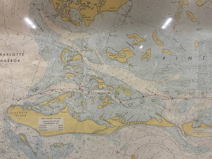
Sold2024Vintage Framed Pine Island & Lacoste Island MapVintage full color paper map, marked on top Pine island, Charlotte harbor and Lacosta island. Showing waterways and directions. Framed in a wooden frame. Approx 14 x 18 inches window measures 11.5 x 1See Sold Price
Sold2020New Map of That Portion of North America 1851New Map of That Portion of North America Exhibiting the United States and Territories, the Canadas, New Brunswick, Nova Scotia and Mexico also Central America and the West India Islands, 1851, Jacob MSee Sold Price
Sold2017Tallis: Map of the Caribbean & West India Islands, 18511851 Tallis Map of the Caribbean -- West India Islands. This is an ornate and highly decorative map of the Caribbean from the Bahamas to Columbia and Venezuela. The map features three vignettes and faSee Sold Price
Sold2022Long Island Pictorial MapA Map of Long Island. Courtland Smith. Billboard Barn: 1933. Vintage map. Scattered creases. Overall 22 1/2" x 30".See Sold Price
Sold2020NEW ZEALAND. Shows NZ Company settlements in 1851.TITLE/CONTENT OF MAP: 'New Zealand' Vignettes: Auckland; Mount Egmont from New Plymouth; Wellington. North Island is indicated as "New Ulster or North Island"; the island known today as South Island iSee Sold Price
Sold2018Double-Sided Printed Partial Mapof Long Island, New York, Baker Crowell, Inc., depicting Great Neck, Long Island Sight lines 24 1/2"h x 31 1/4"w By descent from the Estate of Robert Weeks DeForest and Emily Johnson DeForest.See Sold Price
Sold2018OG 1950's Dole Map Hawaiian Islands Joseph Feher PosterDole Map of the Hawaiian Islands, by Joseph Feher. Has the orginal shipping containor with the Dole Label on the mailing tube. Poster is marked on the bottom left 1950 by Hawaiian Pineapple Company. TSee Sold Price
Sold2018Pease and Niles Gazetteer of the States of ConnecPease and Niles Gazetteer of the States of Connecticut and Rhode Island, Hartford, 1813 Map.-- Dimensions: --- US Shipping charge: $20See Sold Price
7 hrs LeftJasper52CABOOL PUNJAB & BELOOCHISTAN. Pakistan Afghanistan Kabul. RAPKIN/TALLIS 1851 map$150
3 days LeftTrillium Antique Prints & Rare BooksSanson - Map of the Philippines and Ladrones Islands$75
712 Lots AwayThe Benefit Shop Foundation Inc.Mid Century & Vintage Postcards Germany, Paris +$20(4 bids)
Jun 04John Moran Auctioneers, Inc.Mina Mannuk (b. 1934, Inuit; Belcher Islands/Sanikiluaq), A carved stone bird sculpture, mid/late$50
3 days LeftTrillium Antique Prints & Rare BooksDe Jode, Rare, pub. 1593 - Map of Europe (Nova Totius Europae Tabula)$160(4 bids)
Featured7 hrs LeftJasper52Suite de l’Ocean Oriental…' East Asia/Indies. Western Pacific. BELLIN 1746 map$200
6 days LeftJasper521652 Sanson Map of Parts od Southeast Asia -- Les Isles de la Sonde. Entre Lesquelles sont Sumatra,$200
Jun 08Leon GalleryAbraham Ortelius (1527 - 1598) - Indiae Orientalis (Philippines/China/ India/ Southeast Asia)₱200,000
7 hrs LeftJasper52JAPAN & COREA /Korea. Yedo (Tokyo) King-ki-Tao (Seoul). TALLIS & RAPKIN 1851 map$160
7 hrs LeftJasper52CABOOL PUNJAB & BELOOCHISTAN. Pakistan Afghanistan Kabul.TALLIS/RAPKIN 1851 map$150
Jun 02Carlsen Gallery, Inc.4 CIVIL WAR BELT PLATES INC. NCO EARLY CW PATTERN, 1851 OFFICER SWORD BELT, EXCAVATED FROM RICHMOND$150(1 bid)


![POLYNESIA/PACIFIC ISLANDS. inc Sandwich/Hawaiian islands. RAPKIN/TALLIS 1851 map: CAPTION PRINTED BELOW PICTURE: 'Polynesia or Islands in the Pacific Ocean' Vignettes: Resolution Bay, Marquesas; Harbour of Dory, New Guinea; Otaheite [Tahiti]; Kalakakooa, Sandwich Islands [Hawaiian](https://p1.liveauctioneers.com/5584/298779/159029476_1_x.jpg?height=310&quality=70&version=1692132475)


![POLYNESIA/PACIFIC ISLANDS. inc Sandwich/Hawaiian: TITLE/CONTENT OF MAP: 'Polynesia or Islands in the Pacific Ocean' Vignettes: Resolution Bay, Marquesas; Harbour of Dory, New Guinea; Otaheite [Tahiti]; Kalakakooa, Sandwich Islands [Hawaiian islands].](https://p1.liveauctioneers.com/5584/128489/65352606_1_x.jpg?height=310&quality=70&version=1538523113)
![POLYNESIA/PACIFIC ISLANDS. inc Sandwich/Hawaiian: Reserve Reduced! TITLE/CONTENT OF MAP: 'Polynesia or Islands in the Pacific Ocean' Vignettes: Resolution Bay, Marquesas; Harbour of Dory, New Guinea; Otaheite [Tahiti]; Kalakakooa, Sandwich Islands [H](https://p1.liveauctioneers.com/5584/129679/65959649_1_x.jpg?height=310&quality=70&version=1540338370)