Sold2016KONVOLUT AUS 10 LANDKARTEN UND STADTANSICHTEN U.a. vonKONVOLUT AUS 10 LANDKARTEN UND STADTANSICHTEN U.a. von Jansonius, Hondius, Sanson, Blaeu, Homann-Erben, 16.-19. Jh. Kupferstich, z.T. koloriert, Holzschnitt, Stahlstich, auf unterschiedl. Papieren. MaSee Sold Price
Sold2023Seutter - Map of North America including Great Lakes, Florida, Virginia, New England, Mexico, WestThis engraving is from a composite atlas presented by the Homann Heirs. Many of the maps in the collection were completed by J. B. Homann, Homann Erben, M. Seutter, and T. C. Lotter. The maps were oriSee Sold Price
Sold2024Histroric world map, ''PlaniglobHistroric world map, ''Planiglobii Terrestris Mappa Universalis. Utrumq Hemisphaerium Orient et Occidentale repraesentans ex IV. mappis generalibus'', partly col. Copper engraving by Homann Erben 1746See Sold Price
Sold2015Solothurn "Canton Solothurn Sive Pagus HelvetiaeSolothurn "Canton Solothurn Sive Pagus Helvetiae Solodurensis cum Confinibus". Kolorierte Kupferstichkarte nach Gabriel Walser, hg. von Homanns Erben, Nürnberg, 1766. 47x56,5 cm. Gerahmt. - Mit zweiSee Sold Price
Sold2017Homann: Antique Map of Belgium Holland Germany FranceTitle: Map of Belgium, Holland, Germany, and France by Homann Date: c 1747 Medium: Hand Colored Copper Plate Engraving Dimensions (in.): 22.5 x 20 No Reserve: This lot starts at $1 and has no reserveSee Sold Price
Sold2016Homann (Heirs of) - Partie Orientale de la Nouvelleafter Bellin, from Hudson Bay and Lake Ontario to Newfoundland, large decorative title cartouche lower right, engraved map, 450 x 560mm., central vertical fold, Nuremberg, 1755 § Holland (Samuel)See Sold Price
Sold2019Holland and her colonies, c.1720Heading: Author: Homann, Johann Baptiste Title: Belgii pars Septentrionalis communi nomine Vulgo Hollandia nancupata Continens Statum Potentissimae Batavorum Reipublicae sev Provincias VII FoederatasSee Sold Price
Sold2024J B HomannJ B Homann A General Map of Great Britain and Ireland, with Part of Holland.., hand coloured engraving, circa 1750, 52 x 60cm (visible)See Sold Price
Sold2019Homann Heirs, " Great Britain and Ireland, with PartsHomann Heirs, " Great Britain and Ireland, with Parts of Holland, Flanders, France..," 18th c., hand colored, H. - 19 in., W. - 24 in.See Sold Price
Sold2021Double hemisphere world map with additionalTitle: Double hemisphere world map with additional projections. 1752 by Homann Heirs Date/Period: 1762 Materials: Copperplate engraved Size: 24 x 20 1/2 1762, by J. B. Homann & Homann Heirs, from "AtlSee Sold Price
Sold2021The America’s 1762 by Homann HeirsTitle: The America’s 1762 by Homann Heirs Date/Period: 1762 Materials: Copperplate engraved Size: 24 x 20 1/2 1762, by J. B. Homann & Homann Heirs, from "Atlas Homannianus Mathematico-Historice DeliSee Sold Price
Sold2021Solar system ‘systema solare et planetraruin’ 1762 byTitle: Solar system ‘systema solare et planetraruin’ 1762 by Homann Heirs Date/Period: 1762 Materials: Copperplate engraved Size: 24 x 20 1/2 1762, by J. B. Homann & Homann Heirs, from "Atlas HomaSee Sold Price
Sold2020Scotland 1762 by Homann HeirsTitle: Scotland 1762 by Homann Heirs Date/Period: 1762 Materials: Copper plate engraved Size: 24 x 20 1/2" Description: 1762, by J. B. Homann & Homann Heirs, from "Atlas Homannianus Mathematico-HistorSee Sold Price
Sold2020Ireland 1762 by Homann HeirsTitle: Ireland 1762 by Homann Heirs Date/Period: 1762 Materials: Copper plate engraved Size: 24 x 20 1/2" Description: 1762, by J. B. Homann & Homann Heirs, from "Atlas Homannianus Mathematico-HistoriSee Sold Price
Sold2023Attributed to Karel Bondam (Dutch, 20th c.)Attributed to Karel Bondam (Dutch, 20th c.) , "Peasant's Cottage in North Brabant, Holland", oil on canvas, with later added signature lower right, titled and inscribed on stretcher, 11 3/4 in. x 15 3See Sold Price
Sold2016Regni Sinae vel Sinae Propriae by Homann Heirs 1745Map Title: Regni Sinae vel Sinae Propriae Artist: Homann Heirs Publisher: Homann Heirs, Nuremberg Date: 1745 Size: 22.5 x 20.2 inches Medium: Hand colored copper plate engraving A very detailed map ofSee Sold Price
Sold20171753 Homann Map of Italy1753 Homann Map of Italy -- Homann Heirs: Italia in suos Status divisa et ex prototypo del Isliano…. J. Homann, 1753 Nurnberg, A gorgeous map of Italy including Sicily, Corsica, and also Sardinia exSee Sold Price
Sold20241747 Thomas Kitchin Engraving Map of Holland, Utrecht, Gelderland, Zeeland, Flanders and Brabant1747 Engraving Thomas Kitchin Map of Holland, Utrecht, Gelderland, Zeeland, Dutch Flanders and Dutch Brabant. London Magazine. Shows towns, cities, roads, rivers, and some topography. Page measures aSee Sold Price
Sold2023MAP: ANTIQUE 1737 JOHANN BAPTIST .B HOMANN- AFRICA SECUNDUM LEGITIMASDescription: Framed Antique 1737 - J.B HOMANN- AFRICA SECUNDUM LEGITIMAS. Johann Baptist Homann (20 March 1664 -1 July 1724) was a German geographer and cartographer, who also made maps of the AmericaSee Sold Price
Sold2022Johann Baptiste Homann (1664 - 1724) - Map of America 1746 Homann HeirsAntique map titled 'Americae Mappa generalis Secundum legimitas projectionis Stereiographiae regulas (..)'. This map is the second issue of the earlier edition by J. B. Homann and shows considerable cSee Sold Price
Sold2020Netherlands 1747 Map of Holland, Utrecht"A New & Exact Map of the Provinces of Holland, Utrecht, Gelderland, Zeeland, Dutch Flanders and Dutch Brabant" Copper Engraved Map Published 1732-85, London for "The London Magazine" Folds as issued.See Sold Price
Sold2022Homann Atlas Compeniarius, 1748HOMANN, Johann Baptist (1663-1724). Atlas Compeniarius quinquaginta selectarum tabularum geographicarum Homanni. Nuremberg: Heirs of J.B. Homann, 1748 [maps dated 1741-1749]. Folio (21 x 12 inches). ESee Sold Price
Sold2018Homann: Antique Map of New England, 1720The map names New England as "Almouchi Cosen" as well as Nova Anglia, while present-day New York State is named variously as New Jork, Nieuw Nederland and Novum Belgium (New York, New Netherlands andSee Sold Price
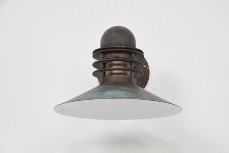
Sold2021Alfred Homann & Ole V. Kjaer, 'Nyhavn' Outdoor SconceAlfred Homann & Ole V. Kjaer 'Nyhavn' outdoor sconce, ca. 1976 Patinated copper, painted copper. Manufactured by Louis Poulsen, Denmark. Mount plate with manufacturer's labels. Dimensions: 9" H 12.25"See Sold Price
May 19Lodestar Auctions1967 Signed ? Haas Brabant Holland Impressionist Hunter Scene Oil Painting$100
9 hrs LeftJeschke Jadi Auctions Berlin GmbHPlan du Mayence. Accurater Plan der Churf.- Ertzbisch Residenz Stadt Maynz. Altkolorierter€200
9 hrs LeftJeschke Jadi Auctions Berlin GmbHIchnographica Urbis Wratislaviensis Delineatio, Praeter Alia Exactissime Etiam Repraesentans Singula€200
9 hrs LeftJeschke Jadi Auctions Berlin GmbHSammlung von drei alten Karten. Je altkolorierter Kupferstich auf Papier. 38,5 x 52,5 cm bis 50,5 x€200
9 hrs LeftJeschke Jadi Auctions Berlin GmbHMayer, nach Tobias Carte critique de l'Allemagne...Germaniae atqve ein ea Locorvm Principaliorvm€300
Featured4 days LeftJasper52RARE MAP, 1762, 15 Cities of the Safavid era Persian Empire by J. B. Homann$600
May 05Tremont Auctions18th century map "Americae Septentrion" by Homann. Rarer early edition. Framed. Holes around outer$250(1 bid)
9 hrs LeftJeschke Jadi Auctions Berlin GmbHHomann (Hg.), Georg Gotthilf Jacob Flora von Pommern, oder Beschreibung der in Vor- und€200
9 hrs LeftJeschke Jadi Auctions Berlin GmbHHomann, Johann Baptist 2 teilkolorierte Kupferstichkarten. Um 1730. Je (in Punkten) unter€200
May 10Hermann Historica GmbHA Homann-Webau Eight-Wheel Panzer Reconnaissance Car 744, camouflage finish€400
4 days LeftJasper521720 antique MAP of LOWER SAXONY GERMANY 18th CENT. Circulus Saxoniae inferioris$75
4 days LeftJasper521736 LARGE MAP OF SILESIA POLAND SAGANENSIS antique 25 x 4 3/4" Duchy of Krnov$260


![Homann Atlas Compeniarius, 1748: HOMANN, Johann Baptist (1663-1724). Atlas Compeniarius quinquaginta selectarum tabularum geographicarum Homanni. Nuremberg: Heirs of J.B. Homann, 1748 [maps dated 1741-1749]. Folio (21 x 12 inches). E](https://p1.liveauctioneers.com/1968/250616/130196470_1_x.jpg?height=310&quality=70&version=1654190895)