


Item Details
Description
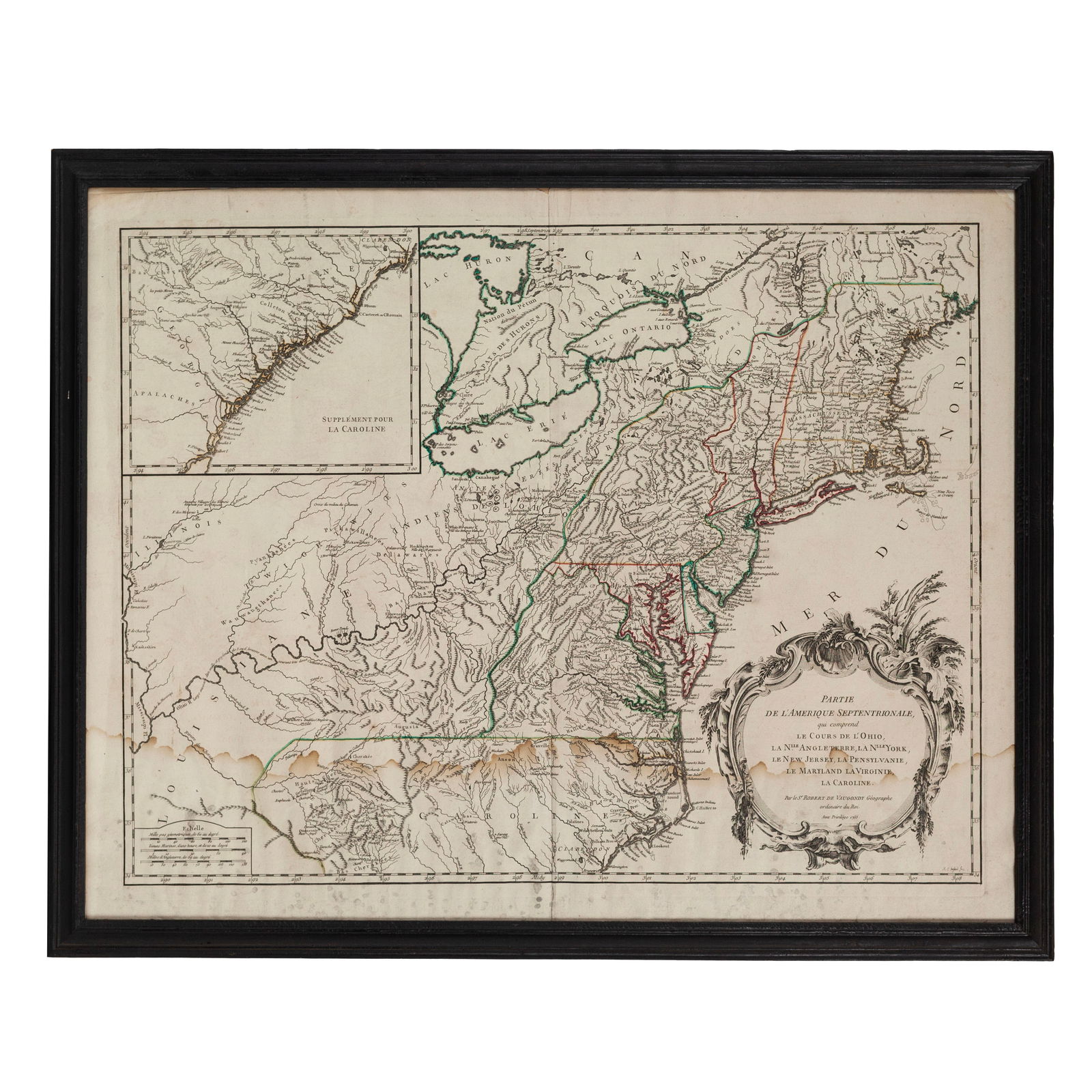
Didier Robert de Vaugondy. Partie de l'Amérique Septentrionale, qui comprend Le Cours de L'Ohio, La Nlle. Angleterre, La Nlle. York, Le New Jersey, La Pennsylvanie, Le Maryland La Virginie, La Caroline. From Atlas Universel. Paris, 1755. ## x ## in. Engraved map with hand coloring. Inset of the coast of Georgia and the Carolinas.
An attractive mid-18th century hand-colored engraved map of the American colonies between the Atlantic ocean and the Ohio and Mississippi rivers. The trans-Allegheny and Great Lakes were hotly contested by colonial powers, erupting in the French & Indian War.
The map shows the confluence of the Allegheny and Monongahela rivers, known as the Forks of the Ohio, and the location of Fort Duquesne.
Based on the map by John Mitchell published the same year.
[Maps, Cartography, Books, Manuscripts,
Buyer's Premium
- 23%
1755 Map Partie de l'Amerique Septentrionale, qui comprend Le Cours de L'Ohio...
Estimate $500 - $750
Current Price (3 bids)
$200
or 4 payments of $50.00 with 
18 bidders are watching this item.
Get approved to bid.
Shipping & Pickup Options
Item located in Columbus, OH, USSee Policy for Shipping
Payment
Accepts seamless payments through LiveAuctioneers

Civil War & African American History: Sherman
Columbus, OH, USA


![Portrait of a Reverend [Daguerreotype]: Quarter plate daguerreotype. Period wood wall frame. A haunting daguerreotype of an older, bespectacled preacher in a stunning wood frame. The man appears to be clad in silk robes consistent with a](https://p1.liveauctioneers.com/7226/322253/173251708_1_x.jpg?height=310&quality=70&version=1710004847)
![Mining Operation, Gold Rush Era [Ambrotype]: Sixth plate outdoor ambrotype. Full leatherette case. A sharp mining scene showing a behatted figure standing on a steep hill next to a long placer. Among the tall trees is a small log cabin and an](https://p1.liveauctioneers.com/7226/322253/173251709_1_x.jpg?height=310&quality=70&version=1710004847)
![Candid Frontier Family [Ambrotype]: c. 1858. Ambrotype. Quarter plate. Half leatherette case. Charming scene that features a rafter of turkeys in the foreground. Most views from the period are stiffly posed, this candid photograph](https://p1.liveauctioneers.com/7226/322253/173251710_1_x.jpg?height=310&quality=70&version=1710004847)
![Photographer & Camera [CDV]: Carte de visite. CDV portrait of a photographer who kneels at his camera, posed to appear as if he's in the process of plying his trade. Rare content. Early Photography, Historic Photography,](https://p1.liveauctioneers.com/7226/322253/173251711_1_x.jpg?height=310&quality=70&version=1710004847)
![Half Plate of Scholar [Ambrotype]: Half plate ambrotype of a bespectacled older man. Full leathette case. The subject, dress neatly in a black overcoat and white shirt, looks off-camera to create a dignified air. The contrast of his](https://p1.liveauctioneers.com/7226/322253/173251712_1_x.jpg?height=310&quality=70&version=1710004847)
![Affectionate Siblings [Ambrotype]: Quarter plate ambrotype portrait. Period gilt plaster wall frame. A lovely ambrotype of two children, most likely siblings. This image features delicate hand tinting throughout. Cut to fit a period](https://p1.liveauctioneers.com/7226/322253/173251713_1_x.jpg?height=310&quality=70&version=1710004847)
![Farrier Portrait [Ambortype] [Occupational]: c. 1863. Tintype. Ninth plate. Housed in a full leatherette case. Interesting occupational portrait of a farrier or blacksmith posed as if he were in the final stages of hammering a horseshoe to](https://p1.liveauctioneers.com/7226/322253/173251714_1_x.jpg?height=310&quality=70&version=1710004847)


Related Maps & Atlases
![After De L'Ise's map of North America: [MAP-NORTH AMERICA] DE L'ISLE, GUILLAUME, after. L'Amerique Septentrionale Dressee sur les Observations de Mrs de l'Academie Royale des Sciences. Amsterdam: R.& J. Ottens, circa 1730 or later. Han](https://p1.liveauctioneers.com/292/326828/175962860_1_x.jpg?height=310&quality=70&version=1713473479)

![Entrée de Norton & Détroit de Bhering. Bering Strait Norton Sound BONNE 1790 map: TITLE/CONTENT OF MAP: [Cook 3e Voyage] Carte de l'entrée de Norton et du Détroit de Bhering, où l'on voit le Cap le plus Oriental de l'Asie et la pointe la plus Occidentale de l'Amé](https://p1.liveauctioneers.com/5584/326888/175994368_1_x.jpg?height=310&quality=70&version=1713903186)
![Entrée de Norton & Détroit de Bhering. Bering Strait Norton Sound BONNE 1788 map: TITLE/CONTENT OF MAP: [Cook 3e Voyage] Carte de l'entrée de Norton et du Détroit de Bhering, où l'on voit le Cap le plus Oriental de l'Asie et la pointe la plus Occidentale de l'Amé](https://p1.liveauctioneers.com/5584/326888/175994363_1_x.jpg?height=310&quality=70&version=1713903186)


![Océanique Partie… des Iles Basses 48 SE Tuamotus Polynesia VANDERMAELEN 1827 map: CAPTION PRINTED BELOW PICTURE: Océanique - Partie de l'Archipel des Iles Basses [Note sur les îles des Amis] - No. 48 The southeastern part of the Tuamotu archipelago in French Polynesia, in](https://p1.liveauctioneers.com/5584/326888/175994688_1_x.jpg?height=310&quality=70&version=1713903186)
![Océanique Partie… des Iles Basses 48 SE Tuamotus Polynesia VANDERMAELEN 1827 map: CAPTION PRINTED BELOW PICTURE: Océanique - Partie de l'Archipel des Iles Basses [Note sur les îles des Amis] - No. 48 The southeastern part of the Tuamotu archipelago in French Polynesia, in](https://p1.liveauctioneers.com/5584/326888/175994459_1_x.jpg?height=310&quality=70&version=1713903186)
![Océanique. Partie… des Iles Basses #49 Gambiers Polynesia. VANDERMAELEN 1827 map: CAPTION PRINTED BELOW PICTURE: Océanique - Partie de l'Archipel des Iles Basses [Note sur les l'île de Rotouma] - No. 49 The Gambier archipelago, south eastern Tuamotus, Polynesia DATE PRINT](https://p1.liveauctioneers.com/5584/326888/175994562_1_x.jpg?height=310&quality=70&version=1713903186)
![Océanique. Partie… des Iles Basses #49 Gambiers Polynesia. VANDERMAELEN 1827 map: CAPTION PRINTED BELOW PICTURE: Océanique - Partie de l'Archipel des Iles Basses [Note sur les l'île de Rotouma] - No. 49 The Gambier archipelago, south eastern Tuamotus, Polynesia DATE PRINT](https://p1.liveauctioneers.com/5584/326888/175994414_1_x.jpg?height=310&quality=70&version=1713903186)
![Océanique Partie… des Iles Basses 43 NE Tuamotus Polynesia VANDERMAELEN 1827 map: CAPTION PRINTED BELOW PICTURE: Océanique - Partie de l'Archipel des Iles Basses [Note sur l'Archipel des îles Basses] - No. 43 The northeastern part of the Tuamotu archipelago of French Poly](https://p1.liveauctioneers.com/5584/326888/175994594_1_x.jpg?height=310&quality=70&version=1713903186)
More Items in Maps & Atlases
View More


Recommended Transportation & Travel Collectibles
View More


Related Searches
TOP