Sold2019General Map of Eastern Asia'. China Japan PhilippinesTITLE/CONTENT OF MAP: 'General Map of Eastern Asia' DATE PRINTED: 1913 IMAGE SIZE: Approx 72.0 x 49.0cm, 28.25 x 19.25 inches (Large); Please note that this is a folding map. TYPE: Antique colour mapSee Sold Price
Sold20191752 INDIA Voyages MAPS Atlas Asia JAPAN China1752 INDIA Voyages MAPS Atlas Asia JAPAN China Philippines Geography The ‘General History of Voyages’ by abbe Prevost is one of the largest and most impressive collections of stories of expeditionSee Sold Price
Sold2024EAST ASIA. Eastern China Central Japan Korea. BARTHOLOMEW 1898 old antique mapTITLE/CONTENT OF MAP: 'Eastern China & Central Japan; Inset map of Tokio; Tozando' DATE PRINTED: 1898 IMAGE SIZE: Approx 43.5 x 32.5cm, 17 x 12.75 inches (Large); Please note that this is a folding maSee Sold Price
Sold20201752 Voyages INDIA MAPS Atlas JAPAN China Asia1752 Voyages INDIA MAPS Atlas JAPAN China Asia Philippines Geography Prevost The ‘General History of Voyages’ by abbe Prevost is one of the largest and most impressive collections of stories of exSee Sold Price
Sold20201898 Rand McNally Map of Asia from China, Japan toTitle/Content of Map: 1898 Rand McNally Map of Asia from China, Japan to Indonesia -- China, French Indo-China, Siam, Malaysia & Korea Cartographer: Rand McNally Year/Place: 1898, Chicago Size: 18.6 xSee Sold Price
Sold20201871 Voyages in ASIA Java Siam CHINA Japan MAP Indones1871 Voyages in ASIA Java Siam CHINA Japan MAP Indonesia Canton Peking Beauvoir “Behind a bend of the Maenam, the entire town of Bangkok appeared in sight. I do not believe that there is a sight inSee Sold Price
Sold20201752 Voyages INDIA Atlas JAPAN China Asia Philippines1752 Voyages INDIA Atlas JAPAN China Asia Philippines Geography Prevost The ‘General History of Voyages’ by abbe Prevost is one of the largest and most impressive collections of stories of expeditSee Sold Price
Sold20201747 Voyages INDIA MAPS Japan China Asia Africa Ghana1747 Voyages INDIA MAPS Japan China Asia Africa Ghana Geography Prevost 7v RARE The ‘General History of Voyages’ by abbe Prevost is one of the largest and most impressive collections of stories ofSee Sold Price
Sold2024CHINA & JAPAN showing Opium Wars battlefields & dates. JOHNSTON 1913 old mapCAPTION PRINTED BELOW PICTURE: 'China and Japan // Islands of Japan' DATE PRINTED: 1913 IMAGE SIZE: Approx 34.5 x 43.5cm, 13.5 x 17.25 inches (Large); Please note that this is a folding map. TYPE: AntSee Sold Price
Sold2018Elizabeth Keith's illustrated travels in AsiaHeading: Author: Keith, Elizabeth Title: Eastern Windows: An Artists Notes of Travel in Japan, Hokkaido, Korea, China, and the Philippines Place Published: London Publisher:Hutchinson & Co DateSee Sold Price
Sold2023Corea and Japan by John Thomson. East Asia. Korea 1817 old antique map chartTitle: "Corea and Japan" by John Thomson. East Asia. Korea 1817 old antique map chart Description: Corea and Japan' by Drawn & engraved by John & George Menzies for John Thomson's "New General Atlas"See Sold Price
Sold2022ARROWSMITH, AARON. Chart of the Pacific Ocean.ARROWSMITH, AARON. Chart of the Pacific Ocean. Large engraved navigational chart of the coastlines of Russia, Japan, Korea, China, the Philippines, Indonesia, and Australia. 73¼x31½ inches oSee Sold Price
Sold2023TWO ANTIQUE MAPS OF CHINA.Two antique maps of China, including Chinae by Abraham Ortelius, 1595, image 14.25” x 18.25”, with map of Eastern Asia, Le table de la region orientale, image 10” x 13.5”.See Sold Price
Sold2023MAP, China, BellinChina, Korea & Japan. Jacques Nicolas Bellin, Carte des Isles du Japon et la Presqu' Isle de Coree avec les Costes de la Chine Depuis Pekin Jusqua Canton, from Prevost's Histoire Generale des Voyages�See Sold Price
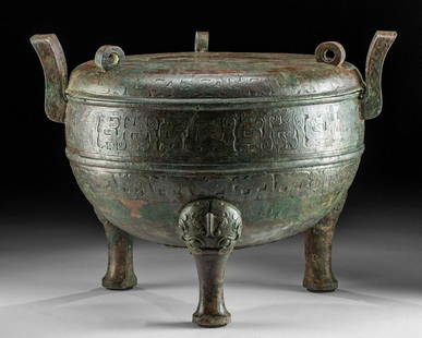
Sold2022Chinese Eastern Zhou Dynasty Lidded Bronze DingEast Asia, China, Eastern Zhou Dynasty, ca. 5th to 4th century BCE. A stunning and large leaded bronze ritualistic cauldron known as a ding vessel with a matched lid standing on elegant tripodal legs.See Sold Price
Sold2018Chinese Wei / Qi Carved Stone Bodhisattva GuanyinEast Asia, China, Eastern Wei or Northern Qi Dynasty, ca. mid 6th century CE. A fascinating limestone sculpture of the bodhisattva Guanyin (Avalokiteshvara), "The Lord Who Gazes Down At The World." ThSee Sold Price
Sold2021Chinese Wei Dynasty Alabaster Seated BuddhaEast Asia, China, Eastern Wei Dynasty, ca. 386 to 535 CE. A stunning sculpture of a seated Buddha hand-carved from creamy beige-hued alabaster. The tranquil figure is seated on a tree stump with his bSee Sold Price
Sold2016The Kingdom of ChinaJohn Speed (1552-1629). Copperplate Engraved Map. Abraham Goos & John Speed: 1627. 17 1/4 x 21 1/2 inches. This superb map of China, Korea and Japan is the only carte-a-figures map made of the region.See Sold Price
Sold2021FOUR-TIER GENERAL STORE CABINET.Wonderful old oak map cabinet sporting a older restoration that shows very nicely. These are getting more difficult to find, especially functional and with such a fantastic finish. Some very slight suSee Sold Price
Sold2015De Bry (Theodore) - Descriptio Hydrographicathe 2-sheet map of Africa and Asia, from the east coast of Brazil to Japan, charting the first Dutch voyage to the East Indies by Houtman, large titlecartouche upper centre of right sheet, ships, compSee Sold Price
Sold2022Lv Peifen 1855-1913 Diary Chinese CalligraphyFine Volumes Lv Peifen1855-1913 Diary 1902 to 1905, fine Chinese calligraphy. Provenance from Mrs. Wu Jiaxin Lv Bowei's granddaughter. preview from Jan.3rd to 7th at 2:00 PM TO 6:00 PM Eastern Time LoSee Sold Price
Sold2023A Chinese Silver Old Coin 1 YuanA Chinese Silver Old Coin 1 Yuan,Attributed to 1911 Xuantong, Preview from Apr. 17th to 21st from 1:00 PM TO 5:00 PM Eastern Time, Location: 15229 Display Court, Rockville MD 20850.See Sold Price
Sold2022Engraving red lacquer general jar in the 19th centurycondition report : A perfect piece of china,The overall carving is perfect,without any repair. For more detailed pictures, please click the link: https://shtvu-my.sharepoint.com/:f:/g/personal/vaSee Sold Price
Sold2022MAPS IN BOOK, Atlases, CareyCarey's Famous 1814 General Atlas. Atlases. Mathew Carey, Carey's General Atlas, Improved and Enlarged: Being a Collection of Maps of the World and Quarters, Their Principal Empires, Kingdoms, &c., 18See Sold Price
May 22Jasper52Suite de l’Ocean Oriental…' East Asia/Indies. Western Pacific. BELLIN 1746 map$200
3 days LeftTrillium Antique Prints & Rare BooksPrevost - Map of China, Korea, Japan, Phlippines and Surrounding Islands$50
6 days LeftBonhamsMaharajah Jagatjit Singh of Kapurthala, My Travels in China, Japan and Java, 1903 Hutchinson & C...£1,200