Sold20231755 Fry Jefferson Map, French Edition First State"Carte de la Virginie et du Maryland dressee sur la grande carte angloise de Mrs. Josue Fry et Pierre Jefferson", hand colored first state of Robert de Vaugondy's French edition of the Fry Jefferson mSee Sold Price
Sold2017Amedee Rosier " The Grand Canal" Oil on PanelAmedee Rosier French 1831 - 1898 Venice, The Grand Canal Signed Lower Left. Label Verso " Montgomery Gallery" San Francisco, California. Dimensions: Art: 11" H x 16"See Sold Price
Sold2016GUILLAUME DELISLE (FRENCH 1675-1726), DOUBLE-PAGEGUILLAUME DELISLE (FRENCH 1675-1726), DOUBLE-PAGE ENGRAVED MAP, "CARTE DE LA LOUISIANE ET DU COURS DU MISSISSIPI", PARIS 1718, SECOND STATE. SIGHT 20 X 26"; FRAMED 26 3/4 X 32 3/4"See Sold Price
Sold2023RARE BUCHOLTZ-LUDWIG ANTEBELLUM POCKET MAP OF VIRGINIARARE BUCHOLTZ-LUDWIG ANTEBELLUM POCKET MAP OF VIRGINIA, hand-colored lithograph, Map of the State of Virginia Containing the Counties, Principal Towns, Railroads, Rivers, Canals & All Other Internal ISee Sold Price
Sold2021Framed 1822 French map of IndianaFramed 1822 French map of Indiana, shows Indian territories and 35 of the 92 counties, but it's in French! 25.5"H x 32"W overall in contemporary frameSee Sold Price
Sold2024Gentleman's Magazine 1778 Canal Map. Belfast to Loughneagh Northern Ireland"A Plan of the River Lagon, and of the intended Navigable Canal from Belfast to Loughneagh?" Copper Engraved Map Published 1778, London for the "Gentleman's Magazine" Folds as issued. Paper Size: 13 xSee Sold Price
Sold2024Gentleman's Magazine 1778 Canal Map. Basingstoke, River Wey, Surrey"A Plan of the Intended Navigable Canal from Basingstoke in the County of Southampton to the River Wey in the county of Surrey" Copper Engraved Map Published 1778, London for the "Gentleman's MagazineSee Sold Price
Sold2020Ludwig Bemelmans, Fox Hunt Scene W/P(American/French 1898-1962), likely created for "Welcome Home," Harper & Brothers, 1960, signed lower right. Framed, not examined out of frame. Frame size: 28 1/2" high, 22" wide. Provenance: PropertySee Sold Price
Sold2022Adelaide Cole Chase American, 1868-1944 Portrait of Mrs. Hollis French, circa 1898Adelaide Cole Chase American, 1868-1944 Portrait of Mrs. Hollis French, circa 1898 Signed Adelaide Chase (ul); inscribed Mrs. Hollis French / 24 W .... St on the stretcher bar Oil on canvas 47 1/2 x 2See Sold Price
Sold2024Glasgow Geography 1825 Antique Map. AfricaCopper Engraved Map Published 1825, Glasgow for "The Glasgow Geography?" by Several Literary Gentleman. Folds as issued. .Paper Size: 11 x 8 inch (28 x 21cm) Very minor toning/offsetting. Good ConditiSee Sold Price
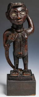
Sold2018Kongo "N'kisi" Magic Fetish, Congo, 19th/early 20th c.Kongo "N'kisi" Magic Fetish, Democratic Republic of Congo, Africa. Carved wooden female effigy shown with snake to breast, raised scarrification, inset glass eyes (female and snake). Well handled patiSee Sold Price
Sold2022Eugene Boudin (French, 1824-1898) Oil PaintingDESCRIPTION: Artist: Eugene Boudin, French (1824 - 1898), Year: circa 1894, Medium: Oil on board, signed. Depicting a dock setting with sailboats. ORIGIN: France DIMENSIONS: painting Size: 12" x 16" |See Sold Price
Sold2020Gastaldi Map of Africa*** START PRICE IS THE RESERVE *** [Africa]. GASTALDI, Giacomo (1500-1566) & FORLANI, Paolo (fl. 1560-1571). La Descrittione dell'Africa. Engraved Map. Venice: Paolo Forlani, 1562. 19 x 25 1/4 inchesSee Sold Price
Sold2022Stanislas Lépine (French, 1835-1892) Le Canal de la ViletteStanislas Lépine (French, 1835-1892) Le Canal de la Vilette signed 'S.Lepine' (lower left), inscribed with title (on remnants of an old label attached to the reverse) oil on canvas 24 x 33cm (9 7See Sold Price
Sold2024Stanford, Edward 1901 Large Map. South AfricaLarge Folio Lithograph Map Published 1901, London for "Stanford's London Atlas of Universal Geography" by Edward Stanford. Centre fold as published. Paper Size: 29 x 21.5 inch (74 x 55cm) Tiny marginSee Sold Price
Sold2024Rapkin, John 1860 Hand Col Map. United StatesHand Colored Steel Engraved Map Published 1860 by The London Printing & Published Company, London for "The Royal Dictionary-Cyclopedia for Universal Reference" by Thomas Wright. Drawn & Engraved by JoSee Sold Price
Sold2024Glasgow Geography 1825 Antique Map. United States of AmericaCopper Engraved Map Published 1825, Glasgow for "The Glasgow Geography?" by Several Literary Gentleman. Folds as issued. .Paper Size: 11 x 8 inch (28 x 21cm) Good ConditionSee Sold Price
Sold2015De Bry (Theodore) - Descriptio Hydrographicathe 2-sheet map of Africa and Asia, from the east coast of Brazil to Japan, charting the first Dutch voyage to the East Indies by Houtman, large titlecartouche upper centre of right sheet, ships, compSee Sold Price
Sold2023Peter Max - Delta - Acrylic on CanvasPeter Max (1937 - ) United States of America. Delta. Acrylic on Canvas. H 43 x W 37 in. The artwork listed is an Original Mixed Media Peter Max Painting titled Delta. Max's art has been exhibited in mSee Sold Price
Sold2018Spanish American War Bond 1898American, 1898, $20 Spanish-American War 3% coupon bond, titled "Three Percent Loan of 1898", "United States of America", "1898-1918", serial number "20982", 16 rows of unclipped coupons, 22-1/2 xSee Sold Price
Sold2022A Songye Wood Male Mask (Kifwebe) Height 25 1/16 inches (63.8 cm).A Songye Wood Male Mask (Kifwebe) Central Africa, Democratic Republic of Congo Height 25 1/16 inches (63.8 cm). Property from Dayton Art Institute, Dayton, Ohio Provenance: Ms. Dianne Komminsk, giftedSee Sold Price
Sold202219th C. Ngombe Iron Ngulu & Mangbetu Iron KnifeCentral Africa, Democratic Republic of Congo, Ngombe chiefdom, ca. 19th to 20th century CE; Mangbetu or Zande peoples, ca. 19th to 20th century CE. A fine pair of iron weapons from central Africa. FirSee Sold Price
Sold2022(REPUBLIC OF TEXAS.) James Hamilton Young. A New Map of Texas, with the Contiguous American &(REPUBLIC OF TEXAS.) James Hamilton Young. A New Map of Texas, with the Contiguous American & Mexican States. Hand-colored engraved map of Texas with inset text panels relating information on its riveSee Sold Price
Sold2022(CIVIL WAR.) John Bachmann. Panorama of the Seat of War.(CIVIL WAR.) John Bachmann. Panorama of the Seat of War. Portfolio of 6 double-page chromolithographed panoramic perspective maps of Confederate states. Folio, 23½x17 inches, contemporary half moSee Sold Price
1 day LeftActivity AuctionsAntique 1787 French Maritime Hydrography Map Eastern Coast United States M Bonne$150
Jun 01Ripley AuctionsGeorge W. Drew, New York (1875-1968), Venetian canal scene with gondola, oil on canvas mounted on$50
Jun 01Ripley AuctionsFelicien Rops, Belgian/French (1833-1898), Woman with Fur, Seated / La femme ? la fourrure, assise,$10
Jun 12Dan Morphy AuctionsPHELPS’S TRAVELERS GUIDE THROUGH THE UNITED STATES; CONTAINING UPWARDS OF SEVEN HUNDRED$1,000
2 days LeftBroward Auction GalleryEmmanuel Coulange Lautrec (France,1824-1898) oil painting antique$40(2 bids)


![Gastaldi Map of Africa: *** START PRICE IS THE RESERVE *** [Africa]. GASTALDI, Giacomo (1500-1566) & FORLANI, Paolo (fl. 1560-1571). La Descrittione dell'Africa. Engraved Map. Venice: Paolo Forlani, 1562. 19 x 25 1/4 inches](https://p1.liveauctioneers.com/1968/163248/82424552_1_x.jpg?height=310&quality=70&version=1583340284)


