Sold2024After R. Wilkinson, Germania AntiquaAfter R. Wilkinson, Germania AntiquaPublished June 1, 1798 by R. Wilkinson, No. 58 Cornhill. Handcolored engraving, late 19th C.Sight: 9-1/4"h x 11-1/2"w, Overall: 14-1/2"h x 16-1/4&quoSee Sold Price
Sold20191798 Wilkinson Map of Northern Africa in Ancient TimesTitle: 1798 Wilkinson Map of Northern Africa in Ancient Times -- Africa Antiqua Date: 1798, London Medium: R Wilkinson Size: 7.9 X 11.1 in. Additional Information: This is an attractive map Northern ASee Sold Price
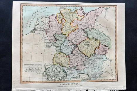
Sold2021Antique Map GERMANIA ANTIQUASize: 11 X 8.5 inches approx. Unframed. Printed 1826.See Sold Price
Sold2019R. Wilkinson Antique Hand Colored Map of SwabiaDescription: R. Wilkinson antique, hand colored map of Swabia. Swabia was a medieval Duchy in southwest Germany, that also included part of Poland. Possibly circa 1822 as indicated by original owner.See Sold Price
Sold2020Obsolete U.S. Courts Probation Officer Badge #470Nice obsolete United States Courts Probation Officer Badge #470 with ID wallet & ID. The badge belonged to William R. Wilkinson from Gary Indiana. Badge is in nice condition with a pinback. Back is unSee Sold Price
Sold201819 Maps: Malte-Brun, British India, others.19 Maps. ++ A New And Accurate Map Of The Southern Provinces, of Hindoostan, shewing The Territories ceded by Tippo Saib, to the Different Powers. Lon: R. Wilkinson, 1800. “T. Foot Sculpt.” Orig hSee Sold Price
Sold2017Wilkinson: Map of Route of Alexander the Great, 18071807 map showing the route of Alexander the Great. Pub. by R. Wilkinson. 8.625 x 11.25. Detailed and attractive map showing the route of Alexander the Great. A beautiful and original antique map. ColoSee Sold Price
Sold2019Delamarche, Felix 1829 Lot of 3 Maps. Europe & Germany"L'Europe a l'Epoque du demembrement de l'Empire de Charlemagne" "L'Europe avan l'Invasion des Barbares" and "Germania Antiqua et regiones Danubium" Copper Engraved Maps Published 1829, Paris for "AtlSee Sold Price
Sold2019Delamarche, Felix 1829 Maps (2) Ancient France, Germany"Germania Antiqua" and "Galliae Antiquae" Copper Engraved Maps Published 1829, Paris for "Atlas de La Geographie..." by Felix Delamarche. Contemporary outline hand colour. Centre fold as published. PaSee Sold Price
Sold2021Wilkes, John 1807 Hand Col Map. Ancient Germany"Germania Antiqua" Finely Hand Colored Copper Engraved Map Published 1796-1828 London for "Encyclopaedia Londinensis, or universal dictionary of arts, sciences and literature" by John Wilkes et al. PaSee Sold Price
Sold2017German Porcelain Portrait VaseA German porcelain portrait vase with an oval portrait of a woman surrounded with gilt accents on a light rose background. Base marked "R/C, Germania, and Germany". 5-1/2 in tall.See Sold Price
Sold2021The Complete Valles of the KingsThe Complete Valles of the Kings Tombes and Treasures of Egypt's Greatest Pharaohs Reeves N., Wilkinson R.H. (1997). London, Thames and Hudson. ISBN: 0-500-05080-5 CHF 50 / 100 EUR 45 / 91 ___________See Sold Price
Sold2023KAREL THOLE - Sacrificio dei DemoniOriginale di copertina per il romanzo di R. Hubbard edito in Germania con il titolo “Opfer der Damonen” nella collana “Vampir Horror Roman” n. 69, Erich Pabel, 1974. Tempera suSee Sold Price
Sold2018Original Color Woodblock by Cyril WilkinsonOriginal Color Woodblock by Cyril Wilkinson 1915 9" by 12" framed R.M. Aquitania. By Cyril Wilkinson (1893-1926) who did poster design for the London Underground and the Cunard Line. In original oak fSee Sold Price
Sold2022MAPS, Egypt, VariousEgypt. Various, [Lot of 2] Carte de l'Egypte Ancienne et Moderne, Dressee sur Celle du R.P. Sicard, et Autres... [and] Aegyptus Antiqua et Aethiopia, 1790-1815 (circa). Hand Color. A. Carte de l'EgyptSee Sold Price
Sold20191813 Wilkinson Map of England and Wales -- England andTitle/Content of Map: 1813 Wilkinson Map of England and Wales -- England and Wales Date: 1813, London Cartographer: R Wilkinson Size: 11.3 X 9.1 in. This is a handsome map of England and Wales with niSee Sold Price
Sold20181801 Wilkinson Map of the Dioceses of England and WalesReserve Reduced! Title/Content of Map: 1801 Wilkinson Map of the Dioceses of England and Wales -- The Dioceses of England with their Alterations to the Present Time Date: 1801, London Cartographer: RSee Sold Price
Sold20221801 Wilkinson Map of the Dioceses of England and WalesTitle: 1801 Wilkinson Map of the Dioceses of England and Wales -- The Dioceses of England with their Alterations to the Present Time Cartographer: R Wilkinson Date/Place: 1801, London Dimensions: 11.2See Sold Price
Sold20181800 Wilkinson Map of Greece and the Balkans -- TurkeyReserve Reduced! Title/Content of Map: 1800 Wilkinson Map of Greece and the Balkans -- Turkey in Europe drawn from many Astronomical Observations Date: 1800, London Cartographer: R Wilkinson Size: 11.See Sold Price
Sold20231818 Wilkinson Map Of Britain and Ireland -- Britain, or the United Kingdom of England, Scotland andTitle: 1818 Wilkinson Map Of Britain and Ireland -- Britain, or the United Kingdom of England, Scotland and Ireland Cartographer: R. Wilkinson Year / Place: 1818, London Map Dimension: 11.2 X 8.8 in.See Sold Price
Sold20221808 Wilkinson Map of Northern Greece, Turkey and Macedonia -- Graecia Pars Septentrionalis aliteeTitle: 1808 Wilkinson Map of Northern Greece, Turkey and Macedonia -- Graecia Pars Septentrionalis alitee Macedonia, Thessallia & Epirus cum Thracia Cartographer: R Wilkinson Year / Place: 1806, LondoSee Sold Price
Sold2024Sotheby, Wilkinson & Hodge 1897 Auction Catalogs: The Montagu Collection and R. Hobart Smith’sSotheby, Wilkinson & Hodge 1897 Auction Catalogs: The Montagu Collection and R. Hobart Smith’s Greek Coins.A trio of original 1897 auction catalogs from the prestigious Sotheby, Wilkinson & Hodge, pSee Sold Price
Sold2020BOOK, THE COPELAND CHINA COLLECTION BY VEGA WILKINSONSoft cover 40 pp. Dozens of illustrations. #CopelandChina #BritishCeramics #BritishPottery #BritishPorcelain #AntiquarianBooks Issued: 1989 Dimensions: 8"L x 8.25"W Manufacturer: R. Spencer Copeland CSee Sold Price
Sold2021WW2 Battle of Britain pilots multiple signed 50th annWW2 Battle of Britain pilots multiple signed 50th ann BOB The Skirmishing cover. Signed by 14 inc, J G Millard, K Wilkinson, P Down, J Etherington, G Garside, A R Russell, Avis Hearn MM, R Jones, B FoSee Sold Price
7 days LeftHermann Historica GmbHA storage case for the ceremonial robe of the Duke of Brunswick-Lüneburg, London, 2nd half of the€600
Joe R. Pyle Complete Auctions & Real EstateModel Frank Lloyd Wright Fallingwater Kaufman house Ohiopyle, PA 23 x 26$100(5 bids)
Joe R. Pyle Complete Auctions & Real EstateVintage Original Bimbo 3 Ring Circus Arcade Machine 72 x 27 x 24 as found$230(11 bids)
Joe R. Pyle Complete Auctions & Real EstateVintage Bob's Big Boy statue 7 1/2 foot x 4 foot cast metal$600(13 bids)
Joe R. Pyle Complete Auctions & Real EstateVintage Bob's Big Boy statue 7 1/2 foot x 4 foot cast metal$1,500(8 bids)
May 21Capitoliumart s.r.l.RON ARAD Two Legs And A Table prodotto da Ron Arad Studio presso Marzorati Rochetti, Cantù.€12,000


![MAPS, Egypt, Various: Egypt. Various, [Lot of 2] Carte de l'Egypte Ancienne et Moderne, Dressee sur Celle du R.P. Sicard, et Autres... [and] Aegyptus Antiqua et Aethiopia, 1790-1815 (circa). Hand Color. A. Carte de l'Egypt](https://p1.liveauctioneers.com/6576/263260/137251671_1_x.jpg?height=310&quality=70&version=1664399834)


