Sold2022LUFTWAFFE FLIGHT MAP OF GERMANY, FRANCE AND ENGLANDDouble-sided ‘Luft-Navigationskarte’ (‘Air Navigation Map’), 26.5 x 24 in., printed on weatherproofed canvas and produced by the General Staff of the Luftwaffe, circa 1941. BSee Sold Price
Sold2017Lineol 3 Luftwaffe Flieger Flag Officer SoldierA great looking flag with excellent paint. Couple of small cracks and some small spots of touch-up which look normal. All 3 men with the yellow collar insignia of the flight branch of the Luftwaffe. 3See Sold Price
Sold2022Board Clock Ju-88 German Air Force.Board Clock Ju-88 German Air Force.oard Clock Bo-Uk-3, Fl.23888 Luftwaffe (German Air Force). Rare Blindfluguhr (board clock) Bo-Uk-3, Fl.23888 German Air Force.Blind flight watch especially for the rSee Sold Price
Sold2020WWII German Luftwaffe Flight Boots w/ EphemeraA pair of WWII era German Luftwaffe flight boots comprised of leather & suede with a sheepskin interior lining. Approx. size US 15, UK 49.5. Some stains and wear to leather present; hole towards top oSee Sold Price
Sold2023ATLASES AND POCKET MAPS. 3 PIECES TOGETHERATLASES AND POCKET MAPS. A lot of 3 pieces sold together. Generally good condition, various imperfections. Including: Wyld, James. WORLD MAP. London: James Wyld, n.d. 12mo. Folding map, mounted to cloSee Sold Price
Sold2018LUFTWAFFE FLIGHT BAR FOR BATTLEFIELDPILOT, UNMARKED BRONZE FLAT PIN - EXCELLENTSee Sold Price
Sold2024Puerto Rico Antique Maps (3)Group of 3 antique folding map sea charts. One of Puerto Rico. Another of San Juan Harbor. The third a composite including Mayaguez Bay. Washington, D.C.: 1899. All fold as issued.See Sold Price
Sold2020Museum Repro WWII German Luftwaffe Flight TunicMuseum quality reproduction WWII German Luftwaffe 1st Model flight personel tunic. Comes with Flieger/Para shoulder boards, unfinished Tress pinned to sleeve, and unit pin on collar. Size 40-42.See Sold Price
Sold2022Set of Framed 19th C. Relief Maps (3)Printed in Chicago, 1893, set includes a framed relief map of the United States, a relief map of Europe, and a relief map of the world, 27" x 37 1/2" sight, 34" x 47 1/2" framed.See Sold Price
Sold2022ANTIQUE MAPS, 3 PCS, H 6.25"-14.75", CHARLESTON, SAVANNAH & YORKSHIREANTIQUE MAPS, 3 PCS, H 6.25"-14.75", CHARLESTON, SAVANNAH & YORKSHIRE A selection of three antique maps. Includes one hand-colored 'Parts of North and South Carolina' coastal map (H 14.75" x W 13"), oSee Sold Price
Sold2020Vintage Montana Maps (3)Three vintage Montana maps. They measure 11-in. x 17-in. to 15.25-in. x x22.75-in. VG-EX/EX condition. Unframed, loose and not glued or mounted. If lot is absent of a condition report a condition repoSee Sold Price
Sold2023Air Jordan 1 Flight 3 Prem Sneakers Sz 10 1/2Experience the ultimate fusion of style and performance with the Air Jordan 1 Flight 3 Prem Sneakers. These sneakers boast a premium design and the iconic Air Jordan silhouette, making them a must-havSee Sold Price
Sold2019Bartholomew, John 1922 South America Maps (3)Large Lithograph Maps Published 1922 by The Times, London for "The Times Survey Atlas of the World" Maps by John George Bartholomew of the Edinburgh Geographical Institute. Centre fold as issued. PapeSee Sold Price
Sold2018Pacific Northern Airlines Alaska Flight Maps "FLY PNA TPacific Northern Airlines Alaska Flight Maps "FLY PNA THe Alaska Flag Line" 1960See Sold Price
Sold2023International Astronomical Union CHARTA CAELESTIS Map #3. Framed Engraved Metal Celestial Map. IssueInternational Astronomical Union CHARTA CAELESTIS Map #3. Framed Engraved Metal Celestial Map. Issued by the FRANKLIN MINT; Limited Edition: 1978. Deaccessioned from The Franklin Mint Archives. DimensSee Sold Price
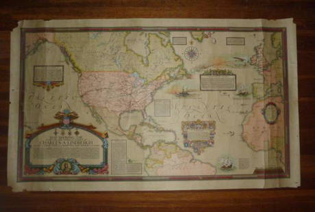
Sold2021Charles Lindberg Authentic Clegg World flight Map1928 Authentic Original Ernest Clegg Charles Lindberg Flight Map. Map was Designed by Ernest Clegg in 1928 . Map Title is “ Map Showing the Overland and Overseas Flights of Charles A. LindbergâSee Sold Price
Sold20221950s PanAm Route Map of Caribbeanan -- PanAmerican Flight Map of New York and CaribbeananTitle: 1950s PanAm Route Map of Caribbeanan -- PanAmerican Flight Map of New York and Caribbeanan Cartographer: PanAm Year / Place: late 1950s c. Map Dimension (in.): 14x 24 in. folded out A very niceSee Sold Price
Sold20221950s PanAm Route Map of Caribbean -- Pan American Flight Map of New York and CaribbeanTitle: 1950s PanAm Route Map of Caribbean -- Pan American Flight Map of New York and Caribbean Cartographer: PanAm Year/Place: late 1950s c. Dimensions: 24 X 14 in. folded out Description: A very niceSee Sold Price
Sold20231950s PanAm Route Map of South America's East Coast -- Pan American Flight Map, South America EastTitle: 1950s PanAm Route Map of South America's East Coast -- Pan American Flight Map, South America East Coast Cartographer: PanAm Year / Place: late 1950s c. Map Dimension (in.): 23.5 X 16.8 in. folSee Sold Price
Sold20201950s Pan Am Flight Map of Mexico and Central AmericaTitle: 1950s Pan Am Flight Map of Mexico and Central America -- Pan American Flight Map of Mexico and Central America Date: 1950s Cartographer: Pan American Size: 17.5 x 24 in. folded out Additional ISee Sold Price
Sold2018John Glenn NASA Flight MapJohn Glenn NASA world map, showing first U.S. manned orbital flight. 1962 Souvenir Edition.See Sold Price
Sold20231950s PanAm Route Map of Caribbeanan -- PanAmerican Flight Map of New York and CaribbeananTitle: 1950s PanAm Route Map of Caribbeanan -- PanAmerican Flight Map of New York and Caribbeanan Cartographer: PanAm Year / Place: late 1950s c. Map Dimension (in.): 14x 24 in. folded out A very niceSee Sold Price
Sold20231950s PanAm Route Map of Caribbean with Personal Notations -- PanAmerican Flight Map of New York andTitle: 1950s PanAm Route Map of Caribbean with Personal Notations -- PanAmerican Flight Map of New York and Caribbean Cartographer: PanAm Year / Place: late 1950s c. Map Dimension (in.): 14x 24 in. foSee Sold Price
1 day LeftDoyle New YorkWilliam Mudford's An Historical Account of the Campaign in the Netherlands in 1815...$1,000
5 days LeftTrillium Antique Prints & Rare BooksBlaeu?s Le Theatre du Monde? ? Volume 3 with 57 Fold Out Maps with Original Hand-coloring, 4 Smaller$1,000(1 bid)
May 09Hunt and Peck Estate Services, Inc.Lot of 3 small maps from Scott's Gazeteer "Vermont, New Hampshire and N.W. Territories"$100
May 16Potter & Potter Auctions[NEW YORK CITY – PICTORIAL MAPS]. Group of 3 pictorial maps...$200(1 bid)
22 hrs LeftKamy INCHandcrafted 3 Ducks Flight Duck Game Hunter Gift Bird Wildlife Art Bronze Figure$420
624 Lots AwayMynt Auctions1936 USA Trial Flight Rocket Mail #3 Cover to McAllen TX Pilot Signed 2$320
May 10Rail & Road AuctionsFour 1992 Russell's Official Bus Guides and Motor Coach Guide Map Supplements$20
May 10Rail & Road AuctionsNine United Air Lines Paper Items - Travel Brochures, Guides, Maps, Information Packet, Flight Log,$30


![[NEW YORK CITY – PICTORIAL MAPS]. Group of 3 pictorial maps... (1 of 3)](https://p1.liveauctioneers.com/928/325952/175495562_1_x.jpg?height=282&quality=70&version=1712935174)


