Sold2017JOHN SPEEDE (BRITISH 1552 - 1629) A HAND COLOREDJOHN SPEEDE (BRITISH 1552 - 1629) A HAND COLORED ENGRAVED MAP, "SURREY DESCRIBED AND DIVIDED 1610." 15" x 20"See Sold Price
Sold2017Engraved Map, After John SpeedeAfter John Speede (British, 1552-1629), "The Kingdome of Great Britaine and Ireland," hand colored engraving, engraved by Joducus Hondius, english text on verso, overall (with frame): 23.35"h x 27.25"See Sold Price
Sold2015Kingdom of IrelandJohn Speed (1552-1629). Engraved map. London: 1610 (1676). 17 1/4 x 22 inches. A rare, early printing of John Speed’s renowned map of Ireland. The map is decorated with a panel of costume figures deSee Sold Price
Sold2019* SPEED, John (1552-1629). Holy Iland / Garnsey / Farne* SPEED, John (1552-1629). Holy Iland / Garnsey / Farne / Iarsey. [London,] 1610 [but 1676]. Hand-colored engraved map of Holy Island and Lindisfarne off the Northumberland Coast, and Guernsey and JerSee Sold Price
Sold2016The Kingdom of ChinaJohn Speed (1552-1629). Copperplate Engraved Map. Abraham Goos & John Speed: 1627. 17 1/4 x 21 1/2 inches. This superb map of China, Korea and Japan is the only carte-a-figures map made of the region.See Sold Price
Sold2021After John Speed. Map of Virginia and MarylandAfter John Speed (English, 1552-1629). A hand-colored engraved map of Virginia and Maryland, engraved by Francis Lamb (English, 1651-1700). Sold by Thomas Basset in Fleet Street and Richard Chiswell iSee Sold Price
Sold2022John Speed, Two Vintage Copper Engraved MapsJOHN SPEED (British, 1552-1629), Invasions of England & Ireland with al their Civill Wars Since the Conquest, 1676, and Britain as it was Divided, two copper engraved maps with hand-coloring, image (eSee Sold Price
Sold2022JOHN SPEED 17TH C. MAP, GREAT BRITAIN.John Speed map, ”The Kingdome of Great Britaine and Ireland,” engraved by J. Hondius, printed by Sudbury and Humble, London, 1610, with insets of London, Edinburgh, and the Orkney Islands,See Sold Price
Sold2017America, Rare Early Map of the Americas"America", Rare Early Map of the Americas by Jodocus Hondius (Flemish/Dutch, 1563-1612) for a French edition of Mercator's Atlas, North and South America, hand-colored copper engraved map, published ASee Sold Price
Sold2022Speed, John (1552-1629) The Historie of Great Britaine under the Conquests of the Romans, Saxons,Speed, John (1552-1629) The Historie of Great Britaine under the Conquests of the Romans, Saxons, Danes, and Normans. London: Printed by John Dawson for George Humble, 1632.Two folio volumes, third edSee Sold Price
Sold2016JOHN SPEED (BRITISH, 1552-1629) MAP OF THE WORLDJOHN SPEED (BRITISH, 1552-1629) MAP OF THE WORLD, (UPDATED 6/14/16) hand-colored engraving on laid paper, titled "A New and Accurat Map of the World Drawne according to ye truest Descriptions latest DSee Sold Price
Sold2022(COLONIAL NORTH AMERICA.) John Senex, Charles Price, and John Maxwell. North America.(COLONIAL NORTH AMERICA.) John Senex, Charles Price, and John Maxwell. North America. Large engraved map of North America on two sheets of laid paper joined. 39x26¾ inches overall, wide margins;See Sold Price
Sold2022EARLY MAP OF AFRICA"Africae" "Newly Done into English John Speede / G. Humble 1626" engraved by Abraham Goos, bookplate "The Description of Africa" on reverse, hand colored; minor tear, foxing, toning, tape marks; frameSee Sold Price
Sold2020Atlases.- Sharpe (John) Sharpe's Corresponding Atlas,Atlases.- Sharpe (John) Sharpe's Corresponding Atlas, 54 engraved maps by J.W.Lowry, all hand-coloured in outline, 2 double-page (6/7 & 19/20), 2 world maps slightly shaved at fore-edge affecting imprSee Sold Price
Sold2022SELBY (JOHN PRIDEAUX) Plates to Selby's Illustrations of British Ornithology, vol. 1 (of 2, and ...SELBY (JOHN PRIDEAUX) Plates to Selby's Illustrations of British Ornithology, vol. 1 (of 2, and without text volumes), engraved pictorial title, 4 uncoloured engraved anatomical plates (numbered 1-4)See Sold Price
Sold2022Britain.- Speed (John) England Wales and Scotland... from a farr Larger Voulume done by John Speed,British Isles.- Speed (John) England Wales and Scotland... from a farr Larger Voulume done by John Speed, engraved title, table of distances, and 63 uncoloured engraved maps by Pieter Van den Keere inSee Sold Price
Sold2022CELESTIAL ATLAS JAMIESON (ALEXANDER) A Celestial Atlas Comprising a Systematic Display of the He...CELESTIAL ATLAS JAMIESON (ALEXANDER) A Celestial Atlas Comprising a Systematic Display of the Heavens in Series of Thirty Maps, engraved title and dedication leaf, one uncoloured engraved plate, 30 eSee Sold Price
Sold2021Speed map of the Roman Empire, 1626Heading: Author: Speed, John Title: A New Mappe of the Romane Empire Newly Described by John Speede Place Published: London Publisher:G. Humble Date Published: 1626 Description:See Sold Price
Sold2023(NORTH AMERICA.) Henricus Hondius. America Septentrionalis.(NORTH AMERICA.) Henricus Hondius. America Septentrionalis. Double-page engraved map of North America with California as an island and attractive carto-ornamentation. 19¼x23½ inches sheet siSee Sold Price
Sold2023OLD NORTH BRIDGE / CONCORD MASS RELICOak cane with gold-filled handle engraved "Old North Bridge Oak Concord, MA Sept 12 '85. 37 inches.See Sold Price
Sold2018Herman Moll. Atlas Minor. Lon: Bowles, 1732.[Atlas] Herman Moll. Atlas Minor. Lon: Thos. Bowles & John Bowles, (1732). Engraved title + 50 of 62 maps with hand colored outline. Lacking maps 5, 8, 9, 19, 24, 27, 31, 49, 50, 51, 52, and 58. OblonSee Sold Price
Sold2019* SPEED, John (1551/52-1629). The Turkish Empire.* SPEED, John (1551/52-1629). The Turkish Empire. [London], ca 1627-1632. Engraved map with modern hand coloring of the Turkish empire, English text on verso, visible area 15 5/8 x 20 1/4 in. (398 x 5See Sold Price
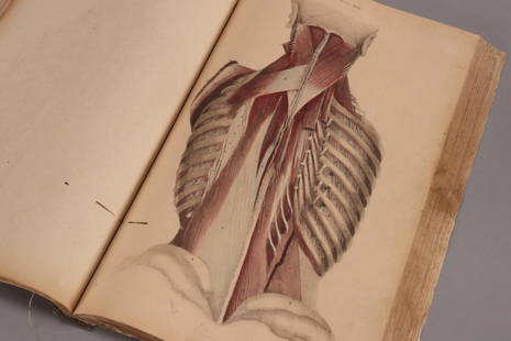
Sold202319th Century Atlas of Anatomia Engraved byWilliam Home Lizars (1788-1859), talented Edinburgh engraver and publisher for Daniel Lizars, for John Lizars Scottish surgeon, anatomist and medical author, comprised of hand coloured engravings on tSee Sold Price
Sold2017Gerardus Mercator - Atlas Minor - Amsterdam, ...Atlas Minor Gerardi Mercatoris. Amsterdam, [1610]. Latin. Third edition. Atlas by the geographer and cartographer Gerardus Mercator (1512-1594). Illustrated title page, an allegoric engraved plate andSee Sold Price
2 days LeftTrillium Antique Prints & Rare BooksCarey & Lea's .. American Atlas - Volume with 46 Originally Hand-colored Folio Maps$1,000(1 bid)
May 19Heartland Artifact Auctions Inc4 1/2" St. Charles Dovetail, Stermer COA, found in Pike Co Illinois north of Atlas by J. Allen$220(3 bids)
May 15Doyle New YorkChinese Export Silver Covered Two-Handled Cup Luen Wo, Shanghai, circa 1900$1,200(2 bids)
3 days LeftTremont AuctionsJohn Speed and Francis Lamb "Map of New England and New York", ca. 1676. Hand colored engraved map$900(3 bids)


![* SPEED, John (1552-1629). Holy Iland / Garnsey / Farne: * SPEED, John (1552-1629). Holy Iland / Garnsey / Farne / Iarsey. [London,] 1610 [but 1676]. Hand-colored engraved map of Holy Island and Lindisfarne off the Northumberland Coast, and Guernsey and Jer](https://p1.liveauctioneers.com/197/138502/70223743_1_x.jpg?height=310&quality=70&version=1553021481)


![Herman Moll. Atlas Minor. Lon: Bowles, 1732.: [Atlas] Herman Moll. Atlas Minor. Lon: Thos. Bowles & John Bowles, (1732). Engraved title + 50 of 62 maps with hand colored outline. Lacking maps 5, 8, 9, 19, 24, 27, 31, 49, 50, 51, 52, and 58. Oblon](https://p1.liveauctioneers.com/179/122672/62428326_1_x.jpg?height=310&quality=70&version=1527272450)
![* SPEED, John (1551/52-1629). The Turkish Empire.: * SPEED, John (1551/52-1629). The Turkish Empire. [London], ca 1627-1632. Engraved map with modern hand coloring of the Turkish empire, English text on verso, visible area 15 5/8 x 20 1/4 in. (398 x 5](https://p1.liveauctioneers.com/197/139716/70820696_1_x.jpg?height=310&quality=70&version=1554835829)
![Gerardus Mercator - Atlas Minor - Amsterdam, ...: Atlas Minor Gerardi Mercatoris. Amsterdam, [1610]. Latin. Third edition. Atlas by the geographer and cartographer Gerardus Mercator (1512-1594). Illustrated title page, an allegoric engraved plate and](https://p1.liveauctioneers.com/1980/104352/53426409_1_x.jpg?height=310&quality=70&version=1496654896)


