Sold2016Coronelli (Vincenzo Maria) - Scotia, Partethe separately titled north and south maps of Scotland joined to form one, decorative title cartouches to each right side, engraved map on 2 sheets, joined, 895 x 630mm., faint central vertical fold,See Sold Price
Sold2017Thomas Kitchin, Maryland and Scotland maps(Scottish, 1718-1784)., "Map of Maryland with the Delaware counties and the southern part of New Jersey," hand colored map, circa 1750, 7 x 9 in. , framed and "Scotland," circa 1760, 7 1/2 x 9 in. , fSee Sold Price
Sold2022Thomson, John The Atlas of ScotlandThomson, John The Atlas of Scotland Edinburgh: for John Thomson & Co., 1832. Large folio (54 x 41cm), contemporary half calf, [4] viii 18, engraved 'Index Map' hand-coloured in outline, 2 engraved plaSee Sold Price
Sold2022Scotland.- Blome (Richard) A Mapp of the Kingdome of Scotland, engraved map with hand-colouring,Scotland.- Blome (Richard) A Mapp of the Kingdome of Scotland, engraving, an excellent impression with full hand-colouring, on laid paper with watermark of bunch of grapes, sheet 390 x 407 mm (15 1/2See Sold Price
Sold2017Jansson: Antique Map of Scotland, 1646Map: 1646 Jansson Map of Scotland -- Provincae Lauden seu Lothien et Linlitouo Cartographer: J. Jansson / Valk & Schenk Year / Place: 1646 c Map Dimensions: 14.2 x 21 in. Condition: Excellent, near fiSee Sold Price
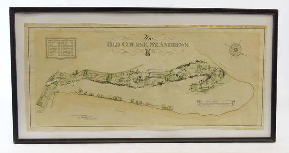
Sold2019Scotland Early Golf MapOld Course St. Andrews Map. Surveyed by A. MacKenize Architect, 1924. McCorquodale & Co., Glasgow, C. 1924. Sight 10 3/4" x 24 1/2".See Sold Price
Sold2020Antique Picot & Co map of England and WalesAntique Picot & Co framed map of England and Wales with part of Scotland. Overall size 37"h x 31"w overall. Paper sight size 27 1/2"h x 21 1/4"w. Published by Picot & Co London and Manchester.See Sold Price
Sold2024Willen Janszoon Blaeu, Scotia Regnum(Dutch, 1571-1638) Hand colored engraved map of Scotland, c. 1642. Framed double sided with book text on verso. Sight: 16-1/2"h x 21-1/4"w Overall: 26"h x 30-3/4"w Provenance: Paulus Swaen, Inc. IndiaSee Sold Price
Sold2022England & Wales.- Bingley (James) The OfficialNO RESERVE England & Wales.- Bingley (James) The Official Travelling Map of England and Wales with part of Scotland, engraving with original hand-colouring, 595 x 485 mm (23 1/2 x 19 in), dissected anSee Sold Price
Sold20212 Maps Goshen and Litchfield E.M. Woodbridge 18522 Maps Goshen and Litchfield E.M. Woodbridge 1852 41"x32", 51"x41"See Sold Price
Sold202226 books & 2 maps on Santa Barbara CaliforniaA grouping of 26 books and 2 maps pertaining to Santa Barbara CaliforniaLot includes: Spaulding, Edward Selden, Adobe Days Among the Channel, Signed Limited Edition of 1015 copies. Privately printed,See Sold Price
Sold20242 Maps CT and RI & General Grant's Long Island2 18th / 19th century maps. H. Harris Rhode Island & Connecticut, hand colored, circa 1802, Thomas and Andrews, 8" x 13 1/2" (with frame 16" x 20 3/4"); Charles Stedman & William Faden Sketch of GenerSee Sold Price
Sold2024Linn, [Lewis F.]. [Oregon Occupation]. In The Senate of the United States. June 6, 1838. With 2 mapsLinn, [Lewis F.]. [Oregon Occupation]. In The Senate of the United States. June 6, 1838. With 2 maps as issued. Provenance: Estate of Meri Jaye, a renowned maritime collector and interior designer ofSee Sold Price
Sold20221872 RR maps of Calif/Nevada – set of 2 mapsScarce lithographs with original hand coloring. Maps show the states of California and Nevada divided into two separate sheets. These very interesting cartographic treasures focus on the developing raSee Sold Price
Sold20162 Maps incl: Scull and Heap. A MAP OF PHILADELPHIA[United States] 2 Maps. ++ N. Scull and G. Heap. A MAP OF PHILADELPHIA And Parts Adjacent. From the folding map’s 2nd appearance in Gentleman’s Magazine [Lon: Dec. 1777], without the table of distSee Sold Price
Sold2022Middle East.- Roberts (David) The Holy Land, Syria,Middle East.- Roberts (David) The Holy Land, Syria, Idumea, Arabia, Egypt & Nubia, 6 vol. in 3, portrait frontispiece, 6 pictorial lithograph titles, 241 tinted lithographs, 2 maps, tissue guards, mosSee Sold Price
Sold2021West Indies.- Speed (John) A Map of Jamaica [on sheetWest Indies.- Speed (John) A Map of Jamaica [on sheet with] Barbados, 2 maps on 1 sheet, each with decorative title cartouches, compass roses, ships and sea monsters, engravings with hand-colouring, 4See Sold Price
Sold2024Framed Map AssortmentFramed Map Assortment (8) items with (3) maps by Willem Blaeu (Dutch, 1571-1638) including c.1660 'Tirolensis', 'Gastinois et Hurepois' and 'Hannoniae et Namurci', (2) maps by Robert de Vaugondy (FrenSee Sold Price
Sold2022Europe.- Stafford (W. C.) and Charles Bell. Italy Illustrated, 2 vol., [c.1860]; and 7 others (9)NO RESERVE Europe.- Stafford (W. C.) and Charles Bell. Italy Illustrated, 2 vol., engraved portraits, vignette-titles, 66 views and 2 maps hand-coloured in outline, occasional scattered spotting, contSee Sold Price
Sold2023WILSON, Charles William, Sir. Picturesque Palestine, Sinai and Egypt. FIRST EDITION, IN THEWILSON, Charles William, Sir (1836-1905). Picturesque Palestine, Sinai and Egypt. New York: D. Appleton and Company, 1880-1883. 40 volumes in 40 original parts, 4to. 2 maps, 40 steel engravings, and 5See Sold Price
Sold2021Map LotLot (2) maps mounted on cardboard "The Supplement to / NORTH AMERICA" and "The Continent and Islands of AMERICA…", each 21" x 47 1/2".See Sold Price
Sold2022John Webber, Plates to Cook's VoyagesJohn Webber (English, 1752-1793). Plates to Cook's Voyages. 63 engravings and 2 maps. Each plate approximately: 10.25 in. high x 16 in. wide. Provenance: Collection of the Warde Family, Hooton PagnellSee Sold Price
Sold2019BURTON, Richard Francis, Sir (1821-1890). FirstBURTON, Richard Francis, Sir (1821-1890). First Footsteps in East Africa; or, An Exploration of Harar. London: Longman, Brown, Green and Longmans, 1856. 8vo. 2 maps (trimmed close affecting neatlineSee Sold Price
Sold2023Maps, Tray ofNew England, Newport, NJ2 Maps and Tray of Newport, New England & New JerseyLargest 22" H x 28" WProperty from the estate of Seymour Stein (1942 - 2023).See Sold Price
May 09Hunt and Peck Estate Services, Inc.Blaeu LEVINIA VICE COMITATUS Province LENNOX Dumbarton Scotland Map$100
May 09Hunt and Peck Estate Services, Inc.John Cary Map Of The Principal Roman Camps, Forts, Walls & C. England/Scotland$50
May 09Hunt and Peck Estate Services, Inc.1822 George Thomson 6 vol. "Thomson's Collection of The Songs of Burns" Signed$400
6 days LeftJasper521810 Ainslie map of County Renfrew near Glasgow in Scotland -- Map made out for John Wilson ESQ.rs$50
6 days LeftJasper521775-1780 Southwest (Arizona, New Mexico, Texas, with most of Mexico) by Bonne & Raynal$160(1 bid)
6 days LeftJasper521775-1780 French Guiana. Dutch Guiana and Northern Brazil. By Bonne and Raynal.$30
6 days LeftJasper521775-1780 Uruguay, Northern Argentina, Southern Brazil, and Rio de Janeiro. By Bonne & Raynal$30


![Thomson, John The Atlas of Scotland: Thomson, John The Atlas of Scotland Edinburgh: for John Thomson & Co., 1832. Large folio (54 x 41cm), contemporary half calf, [4] viii 18, engraved 'Index Map' hand-coloured in outline, 2 engraved pla](https://p1.liveauctioneers.com/94/251108/130828922_1_x.jpg?height=310&quality=70&version=1655281539)


![Linn, [Lewis F.]. [Oregon Occupation]. In The Senate of the United States. June 6, 1838. With 2 maps: Linn, [Lewis F.]. [Oregon Occupation]. In The Senate of the United States. June 6, 1838. With 2 maps as issued. Provenance: Estate of Meri Jaye, a renowned maritime collector and interior designer of](https://p1.liveauctioneers.com/306/325895/175463708_1_x.jpg?height=310&quality=70&version=1712801883)

![2 Maps incl: Scull and Heap. A MAP OF PHILADELPHIA: [United States] 2 Maps. ++ N. Scull and G. Heap. A MAP OF PHILADELPHIA And Parts Adjacent. From the folding map’s 2nd appearance in Gentleman’s Magazine [Lon: Dec. 1777], without the table of dist](https://p1.liveauctioneers.com/179/85723/44108001_1_x.jpg?height=310&quality=70&version=1457209333)

![West Indies.- Speed (John) A Map of Jamaica [on sheet: West Indies.- Speed (John) A Map of Jamaica [on sheet with] Barbados, 2 maps on 1 sheet, each with decorative title cartouches, compass roses, ships and sea monsters, engravings with hand-colouring, 4](https://p1.liveauctioneers.com/5458/196505/99195241_1_x.jpg?height=310&quality=70&version=1614947560)

![Europe.- Stafford (W. C.) and Charles Bell. Italy Illustrated, 2 vol., [c.1860]; and 7 others (9): NO RESERVE Europe.- Stafford (W. C.) and Charles Bell. Italy Illustrated, 2 vol., engraved portraits, vignette-titles, 66 views and 2 maps hand-coloured in outline, occasional scattered spotting, cont](https://p1.liveauctioneers.com/5458/259136/134937278_1_x.jpg?height=310&quality=70&version=1661338494)


![English Medieval Coins - Mixed Cut AR Halfpenny Group [4] (1 of 1)](https://p1.liveauctioneers.com/1191/327727/176560147_1_x.jpg?height=282&quality=70&version=1714130530)

