Sold2023SOUTH AMERICA PHYSICAL. Inset West-East cross section. JOHNSTON 1900 old mapTitle: SOUTH AMERICA PHYSICAL. Inset West-East cross section. JOHNSTON 1900 old map Description: South America (Physical)' by W. & A.K. Johnston, Limited, Edinburgh & London (1900). Antique colour mapSee Sold Price
Sold2023SOUTH AMERICA PHYSICAL. Inset West-East cross section. JOHNSTON 1895 old mapTitle: SOUTH AMERICA PHYSICAL. Inset West-East cross section. JOHNSTON 1895 old map Description: South America (Physical)' by W. & A.K. Johnston, Limited, Edinburgh & London (1895). Antique colour mapSee Sold Price
Sold2023SOUTH AMERICA PHYSICAL. Inset West-East cross section. JOHNSTON 1897 old mapTitle: SOUTH AMERICA PHYSICAL. Inset West-East cross section. JOHNSTON 1897 old map Description: South America (Physical)' by W. & A.K. Johnston (1897). Antique colour map, 26.5 x 20.0cm, 10.5 x 7.75See Sold Price
Sold2023SOUTH AMERICA PHYSICAL. Inset West-East cross section. JOHNSTON 1906 old mapTitle: SOUTH AMERICA PHYSICAL. Inset West-East cross section. JOHNSTON 1906 old map Description: South America (Physical)' by W. & A.K. Johnston, Limited Edinburgh & London (1906). Antique colour map,See Sold Price
Sold2023SOUTH AMERICA NORTHERN. Physical map; Inset map of Rio de Janiero 1909 oldTitle: SOUTH AMERICA NORTHERN. Physical map; Inset map of Rio de Janiero 1909 old Description: South America Northern section; Inset map of Rio' by John Bartholomew & Co; drawn by The Edinburgh GeograSee Sold Price
Sold2024CAMBERWELL Peckham Rye East Dulwich Herne Hill Denmark Hill 1900 old mapTITLE OF PRINT (NOT PRINTED ON THE PAGE):'Sheet 62 from Bacon's 1900 London street atlas covering part of South West London including Camberwell, Peckham, Herne Hill, East Dulwich, Peckham Rye, HerneSee Sold Price
Sold2024Fusan (Busan) harbour, South Korea. ADMIRALTY sea chart 1912 (1955) old mapCAPTION PRINTED BELOW PICTURE: 'Korea - South East Coast - Fusan Harbour' DATE PRINTED: Surveyed to 1913. Published 1912. New edition 1914. Corrections to 1955 IMAGE SIZE: Approx 102.5 x 69.5cm, 40.25See Sold Price
Sold2022Canot's Pair of Early New York Views, 1768CANOT, Pierre Charles (1710-1777), after HOWDELL, Thomas (18th Century). A South West View of the City of New York in North America [WITH] A South East View of the City of New York in North America. ESee Sold Price
Sold2022Bartram 1st Edition of his Southern TravelsBARTRAM, William (1739-1823). Travels through North and South Carolina, Georgia, East & West Florida, the Cherokee country, the extensive territories of the Muscogulges, or Creek Confederacy, and theSee Sold Price
Sold2017America, Rare Early Map of the Americas"America", Rare Early Map of the Americas by Jodocus Hondius (Flemish/Dutch, 1563-1612) for a French edition of Mercator's Atlas, North and South America, hand-colored copper engraved map, published ASee Sold Price
Sold2024The Province of New Jersey Divided into East and WestThe Province of New Jersey Divided into East and WestReproduction map from 1777.Sight: 29 1/2 x 21 3/4 in. (74.9 x 55.2 cm.), Frame: 30 1/4 x 21 1/2 in. (76.8 x 54.6 cm.)See Sold Price
Sold2021FRAMED J.H. COLTON MAP OF NORTH AMERICA CA INSETFramed engraving on paper, Map of North America from the Latest Authorities, published by J.H. Colton (Joseph Hutchins Colton, 1800-1893), No. 86 Cedar St., New York, 1846, drawn and engraved by J.M.See Sold Price
Sold2021A South German sword, Bronze Age, 15th - 14th centuryA South German sword, Bronze Age, 15th - 14th century B.C.Sword with an octagonal full hilt. The cross-section of the blade is curved on both sides with stepped cutting edges. The hilt attached to theSee Sold Price
Sold2019Lori Pambak KazakCa. 1900, 280 x 200 cm, South West Caucasus This large red-ground Lori Pambak displays the characteristic design of this Kazak group: a huge, white central octagon enclosing a powerful green cross motSee Sold Price
Sold2018ACUÑA, Cristóbal de (1597-1676?). Voyages andACUÑA, Cristóbal de (1597-1676?). Voyages and Discoveries in South-America. London: for S. Buckley, 1698. 8vo (190 x 111 mm). 2 folding engraved maps; 3 title-pages. (Pale spotting.) 19th-century taSee Sold Price
Sold2024Pownall Map of North America with the West India IslandsPOWNALL, Thomas (1720-1805). A New Map of North America with the West India Islands, divided according to the Preliminary Articles of Peace, Signed at Versailles, 20, jan 1783, wherein are particularlSee Sold Price
Sold2024THE ENGLISH LAKE DISTRICT. Cumberland, Westmoreland & Lancashire. CARY 1832 mapCAPTION PRINTED BELOW PICTURE: [Sheet 52 - The Lake District. South Cumberland, West Westmoreland and part of Lancashire] DATE PRINTED: 1832 IMAGE SIZE: Approx 54.5 x 66.5cm, 21.25 x 26.25 inches (LarSee Sold Price
Sold2018BRACELET18K White Gold Antique Filigree Design Diamond Bracelet set with (7) old European cut brilliant diamonds from east to west in bezels, approximate total weight 1.0 ct, clarity VS1, color D-F, each acceSee Sold Price
Sold2023WWII U.S. MILITARY FIELD MAPS 1939-1945 - (4)170301 WWII U.S. MILITARY FIELD MAPS 1939-1945 - (4) WWII U.S. military field maps 1939- 1945 to include one East and West Omaha beach scanned "Bigot" Field maps, one France (12500) Isigny field map,See Sold Price
Sold2021Published 12th C. Byzantine Iron Processional CrossAncient Near East / Holy Land, Byzantine Empire, ca. 12th to 14th century CE. An exquisite cast copper-iron processional cross composed of two flared sections pinned together in the center with a castSee Sold Price
Sold2017Nielsen (Kay).- [Asbjørnsen (Peter Christen) &Nielsen (Kay).- [Asbjørnsen (Peter Christen) & Jørgen Moe.] East of the Sun and West of the Moon: Old Tales from the North, number 125 of 500 copies signed by the artist, 25 tipped-in colourSee Sold Price
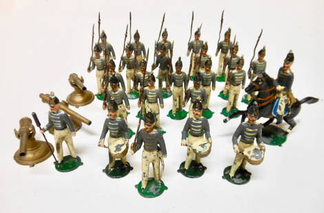
Sold2018Beiser/Eureka RARE 3inch WEST POINT CADETSwith Mounted Officer, Cannons, Artillerymen, Officers Men and Drummers. Circa 1903. SEE O'BRIEN Collecting American Made Toy Soldiers # 3 Page 6. 28 Pieces. Condition Very Good, slight paint chips. CoSee Sold Price
Sold2021MAP, Western Hemisphere, BlaeuBlaeu's Stunning Carte-a-Figures Map of the Americas in Full Contemporary Color. Western Hemisphere - America. Willem Blaeu, Americae Nova Tabula, 1642 (circa). Hand Color. This stunning carte-a-figurSee Sold Price
Sold2024Britains #83 RARE Middlesex YeomanryCirca 1903. 5 pieces. Officer missing plume, the rest in pristine condition tied to card in Whisstock label box. Box in fair condition (missing small section of top side).See Sold Price
1008 Lots AwayRapid Estate Liquidators and Auction GalleryTraditional Handmade Wedding Necklace From Nepal South East Trading Post$250
Jun 25Freeman's | Hindman[Maps & Atlases] A New Map of North America, with the West India Islands...$300
23 hrs LeftBazaar of PersiaUS 1879/1891 Collection of oldest Postage 1c, 2c, 3c 5c, 10c Due Stamps, brown, deep brown, red$700
23 hrs LeftBazaar of PersiaQing Dynasty Large Pilgrim bottle Porcelain Famille-Rose Lime-Ground Vase$500
23 hrs LeftBazaar of PersiaLot 1906-21, Overprinted American Bank Note Co. Portrait issues, Specialized group (Scott 21//57),$30(1 bid)


![Canot's Pair of Early New York Views, 1768: CANOT, Pierre Charles (1710-1777), after HOWDELL, Thomas (18th Century). A South West View of the City of New York in North America [WITH] A South East View of the City of New York in North America. E](https://p1.liveauctioneers.com/1968/250616/130196530_1_x.jpg?height=310&quality=70&version=1654190895)


![THE ENGLISH LAKE DISTRICT. Cumberland, Westmoreland & Lancashire. CARY 1832 map: CAPTION PRINTED BELOW PICTURE: [Sheet 52 - The Lake District. South Cumberland, West Westmoreland and part of Lancashire] DATE PRINTED: 1832 IMAGE SIZE: Approx 54.5 x 66.5cm, 21.25 x 26.25 inches (Lar](https://p1.liveauctioneers.com/5584/332390/179262994_1_x.jpg?height=310&quality=70&version=1717528223)


![Nielsen (Kay).- [Asbjørnsen (Peter Christen) &: Nielsen (Kay).- [Asbjørnsen (Peter Christen) & Jørgen Moe.] East of the Sun and West of the Moon: Old Tales from the North, number 125 of 500 copies signed by the artist, 25 tipped-in colour](https://p1.liveauctioneers.com/5458/112144/57578331_1_x.jpg?height=310&quality=70&version=1510233106)


![[Maps & Atlases] Seutter, Matth(ias).: Novus Orbis sive America... (1 of 2)](https://p1.liveauctioneers.com/65/332523/179335174_1_x.jpg?height=282&quality=70&version=1717709447)


![[Maps & Atlases] A New Map of North America, with the West India Islands... (1 of 2)](https://p1.liveauctioneers.com/65/332523/179335173_1_x.jpg?height=282&quality=70&version=1717709447)


![[EAST] LOT OF 3 VOLUMES SOLD TOGETHER (1 of 5)](https://p1.liveauctioneers.com/8124/333020/179782281_1_x.jpg?height=282&quality=70&version=1718304262)


