Sold2023SOUTH AMERICA PHYSICAL. Inset West-East cross section. JOHNSTON 1895 old mapTitle: SOUTH AMERICA PHYSICAL. Inset West-East cross section. JOHNSTON 1895 old map Description: South America (Physical)' by W. & A.K. Johnston, Limited, Edinburgh & London (1895). Antique colour mapSee Sold Price
Sold2023SOUTH AMERICA PHYSICAL. Inset West-East cross section. JOHNSTON 1900 old mapTitle: SOUTH AMERICA PHYSICAL. Inset West-East cross section. JOHNSTON 1900 old map Description: South America (Physical)' by W. & A.K. Johnston, Limited, Edinburgh & London (1900). Antique colour mapSee Sold Price
Sold2023SOUTH AMERICA PHYSICAL. Inset West-East cross section. JOHNSTON 1897 old mapTitle: SOUTH AMERICA PHYSICAL. Inset West-East cross section. JOHNSTON 1897 old map Description: South America (Physical)' by W. & A.K. Johnston (1897). Antique colour map, 26.5 x 20.0cm, 10.5 x 7.75See Sold Price
Sold2023SOUTH AMERICA PHYSICAL. Inset West-East cross section. JOHNSTON 1906 old mapTitle: SOUTH AMERICA PHYSICAL. Inset West-East cross section. JOHNSTON 1906 old map Description: South America (Physical)' by W. & A.K. Johnston, Limited Edinburgh & London (1906). Antique colour map,See Sold Price
Sold2023SOUTH AMERICA NORTHERN. Physical map; Inset map of Rio de Janiero 1909 oldTitle: SOUTH AMERICA NORTHERN. Physical map; Inset map of Rio de Janiero 1909 old Description: South America Northern section; Inset map of Rio' by John Bartholomew & Co; drawn by The Edinburgh GeograSee Sold Price
Sold2022Canot's Pair of Early New York Views, 1768CANOT, Pierre Charles (1710-1777), after HOWDELL, Thomas (18th Century). A South West View of the City of New York in North America [WITH] A South East View of the City of New York in North America. ESee Sold Price
Sold2022Bartram 1st Edition of his Southern TravelsBARTRAM, William (1739-1823). Travels through North and South Carolina, Georgia, East & West Florida, the Cherokee country, the extensive territories of the Muscogulges, or Creek Confederacy, and theSee Sold Price
Sold2017America, Rare Early Map of the Americas"America", Rare Early Map of the Americas by Jodocus Hondius (Flemish/Dutch, 1563-1612) for a French edition of Mercator's Atlas, North and South America, hand-colored copper engraved map, published ASee Sold Price
Sold2021FRAMED J.H. COLTON MAP OF NORTH AMERICA CA INSETFramed engraving on paper, Map of North America from the Latest Authorities, published by J.H. Colton (Joseph Hutchins Colton, 1800-1893), No. 86 Cedar St., New York, 1846, drawn and engraved by J.M.See Sold Price
2020KazakDated 1312 = 1895, 208 x 169 cm, South West Caucasus In the blue field stand two red trees with perfectly straight trunks and large, grid-like crowns, their angular red branches hung with small yellowSee Sold Price
Sold2021A South German sword, Bronze Age, 15th - 14th centuryA South German sword, Bronze Age, 15th - 14th century B.C.Sword with an octagonal full hilt. The cross-section of the blade is curved on both sides with stepped cutting edges. The hilt attached to theSee Sold Price
Sold2024Abraham Ortelius Map Middle East "Turcici Imperii Descriptio"showing the Turkish Empire, Saudi Arabia, south east Europe and Egypt, hand coloredSee Sold Price
Sold2024Abraham Ortelius Map Middle East "Turcici Imperii Descriptio"showing the Turkish Empire, Saudi Arabia, south east Europe and Egyp tSee Sold Price
Sold2019Lori Pambak KazakCa. 1900, 280 x 200 cm, South West Caucasus This large red-ground Lori Pambak displays the characteristic design of this Kazak group: a huge, white central octagon enclosing a powerful green cross motSee Sold Price
Sold2018ACUÑA, Cristóbal de (1597-1676?). Voyages andACUÑA, Cristóbal de (1597-1676?). Voyages and Discoveries in South-America. London: for S. Buckley, 1698. 8vo (190 x 111 mm). 2 folding engraved maps; 3 title-pages. (Pale spotting.) 19th-century taSee Sold Price
Sold2024Pownall Map of North America with the West India IslandsPOWNALL, Thomas (1720-1805). A New Map of North America with the West India Islands, divided according to the Preliminary Articles of Peace, Signed at Versailles, 20, jan 1783, wherein are particularlSee Sold Price
Sold2018BRACELET18K White Gold Antique Filigree Design Diamond Bracelet set with (7) old European cut brilliant diamonds from east to west in bezels, approximate total weight 1.0 ct, clarity VS1, color D-F, each acceSee Sold Price
Sold2023WWII U.S. MILITARY FIELD MAPS 1939-1945 - (4)170301 WWII U.S. MILITARY FIELD MAPS 1939-1945 - (4) WWII U.S. military field maps 1939- 1945 to include one East and West Omaha beach scanned "Bigot" Field maps, one France (12500) Isigny field map,See Sold Price
Sold2021Published 12th C. Byzantine Iron Processional CrossAncient Near East / Holy Land, Byzantine Empire, ca. 12th to 14th century CE. An exquisite cast copper-iron processional cross composed of two flared sections pinned together in the center with a castSee Sold Price
Sold2017Nielsen (Kay).- [Asbjørnsen (Peter Christen) &Nielsen (Kay).- [Asbjørnsen (Peter Christen) & Jørgen Moe.] East of the Sun and West of the Moon: Old Tales from the North, number 125 of 500 copies signed by the artist, 25 tipped-in colourSee Sold Price
Sold2021MAP, Western Hemisphere, BlaeuBlaeu's Stunning Carte-a-Figures Map of the Americas in Full Contemporary Color. Western Hemisphere - America. Willem Blaeu, Americae Nova Tabula, 1642 (circa). Hand Color. This stunning carte-a-figurSee Sold Price
Sold20241696 Jaillot Mapping The Ottoman Empire at the End of the 17th Centuryoverview of the Turkish Empire at the close of the 17th century. The map is centered on Asia Minor, but extends west to Spain and the Kingdom of Algiers and east to the Caspian Sea and the Arabian PenSee Sold Price
Sold2022Antique South East Asian Bronze Figure"DESCRIPTION: An Antique South East Asian Bronze Figure encompassed by floral decorations and some polychrome accents. Provenance: From a a 69th Street, New York EstateCIRCA: 19th Cent. possibly olderSee Sold Price
Sold2022Three South East Asian Stone LingaLot 264 Three South East Asian Stone Linga each with a cuboid base, an octagonal body and a cylindrical top; the form of these three carvings is the same as 10th Century examples height: 17 3/4 inchSee Sold Price
7 days LeftZikorn Arts & History ObjectsJames Crawford Thom: The Neighbors, 1862, Oil on Canvas$2,500(2 bids)
15 hrs LeftRail & Road AuctionsNine United Air Lines Paper Items - Travel Brochures, Guides, Maps, Information Packet, Flight Log,$30
2 days LeftWorthington Galleries14th c. Sh?hei Japanese Sankaku Yari Spear Polearm Weapon 14th c. Sh?hei Japanese Sankaku Yari Spear$100(1 bid)
May 23South Florida Auction & Estate Sale Services IncOld West PRECIOUS PUSSY Whorehouse Brothel Poster$10(3 bids)
May 18THOS. CORNELL GALLERIES, LTD.GROUP OF ANTIQUE AND VINTAGE MAPS, INC.. NORTH AND SOUTH AMERICA, WORLD MAPS, LOSSES THROUGHOUT,$100(1 bid)
3 days LeftSchilb Antiquarian Rare Books1869 ATLAS 42 MAPS America Africa Australia GERMANY Switzerland Sydow RARE$155(4 bids)
15 hrs LeftRail & Road AuctionsEleven United States Lines & American Merchant Lines Travel Guides, Brochures, Rates, Menus, and$30
5 days LeftFleischer's Auctions[NATIVE AMERICAN] Early 20th c. Clothing w/ Eastern Woodland Style Beadwork$225(2 bids)
3 days LeftSchilb Antiquarian Rare Books1853 INDIANS Legends Traditions Native American Folklore Language SCHOOLCRAFT$115(2 bids)
3 days LeftTopwellsA Rare Early 20th Century Japanese Not Katana Long Temple Shrine Massive Samurai Buddhist Sword in S$3,500(4 bids)
3 days LeftTopwellsAn Early Shinto Japanese Wakizashi Samurai Sword, 17th/18th Century, Signed$750(2 bids)
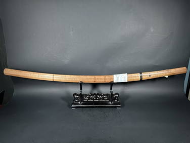
3 days LeftTopwellsA Japanese Samurai Katana Sword in Resting Case, Shirasaya Signed, 17/18th Century$350(1 bid)


![Canot's Pair of Early New York Views, 1768: CANOT, Pierre Charles (1710-1777), after HOWDELL, Thomas (18th Century). A South West View of the City of New York in North America [WITH] A South East View of the City of New York in North America. E](https://p1.liveauctioneers.com/1968/250616/130196530_1_x.jpg?height=310&quality=70&version=1654190895)


![Nielsen (Kay).- [Asbjørnsen (Peter Christen) &: Nielsen (Kay).- [Asbjørnsen (Peter Christen) & Jørgen Moe.] East of the Sun and West of the Moon: Old Tales from the North, number 125 of 500 copies signed by the artist, 25 tipped-in colour](https://p1.liveauctioneers.com/5458/112144/57578331_1_x.jpg?height=310&quality=70&version=1510233106)


![[NATIVE AMERICAN] Early 20th c. Clothing w/ Eastern Woodland Style Beadwork (1 of 20)](https://p1.liveauctioneers.com/7226/322253/173251544_1_x.jpg?height=282&quality=70&version=1710004847)