Sold20191784 Chart of the NW Coast of America and NE Coast of1784 “Chart of the N.W. Coast of America and the N.E. Coast of Asia Explored by Capt. Cook in the years 1778 & 1779…”, published by Harrison and Co., London. This is the smaller version of the rSee Sold Price
Sold2024NW Coast of America & NE Coast of Asia… ROBERTS / DELAROCHETTE. Pacific 1794 mapTITLE/CONTENT OF MAP: 'Chart of the N.W.Coast of America and the N.E. Coast of Asia explored in the years 1778 and 1779 prepared by Lieut. Henry Robert under the immediate inspection of Capt. Cook' DASee Sold Price
Sold2023Book: Captain James Cook Charts & Views, R.A. Skelton Edition, Hakluy Society, Cambridge 1969.Book: Captain James Cook Charts & Views, R.A. Skelton Edition, Hakluy Society, Cambridge 1969.See Sold Price
Sold2019Unknown, "Chart of the NW Coast of America and NE CoastUnknown, "Chart of the NW Coast of America and NE Coast of Asia," 1778-1779, H. - 11 7/8 in., W. - 17 1/2 in.See Sold Price
Sold2018World chart with discoveries of James Cook 1787Heading: Author: Faden, William Title: A New General Chart of the World, Exhibiting the Whole of the Discoveries made by the late Captain James Cook, F.R.S. with the Tracks of the Ships under his ComSee Sold Price
Sold2023World: Captain Cook, Large Folio - A General Chart Exhibiting the Discoveries made by Captain JamesThis fascinating folio engraving is from Captain James Cook & James King's A Voyage to the Pacific Ocean, for making Discoveries in the Northern Hemisphere. To determine the Position and Extent of theSee Sold Price
Sold2021RAYMOND MASSEY "RESOLUTION & DISCOVERY" LITHOGRAPH- RAYMOND A. MASSEY (AMERICAN: 20TH CENTURY)- LITHOGRAPH ON PAPER DEPICTING CAPTAIN JAMES COOK'S THIRD VOYAGE TO THE PACIFIC, AFTER MAKING LANDFALL AT KAWAI POINT, REACHING DOWNWARDS THE SOUTH COAST OSee Sold Price
Sold2021VTG MASSEY RESOLUTION & DISCOVERY SIGNED PRINT 46"VINTAGE MASSEY HMS RESOLUTION & HMS DISCOVERY SHIP PRINT | SHIPS BOATS MARITIME COASTAL NAUTICAL DECOR -OFF THE COAST OF AUSTRALIA THIRD VOYAGE OF CAPTAIN JAMES COOK FROM THE BOOK OF SHIPS PRINTED C 1See Sold Price
Sold2023James Cook Antiquated MapAntiquated framed and glazed map / 'agenera chart' depicting the voyages and discoveries of Captain James Cook height 28 in. x width 42 in. x depth 1.5 in. We happily provide seamless shippiSee Sold Price
Sold2016James Cook, Carte Des Decouvertes Mer PacifiqueAn engraved map / chart of the Pacific Islands, Carte Des Decouvertes faites dans la Mer Pacifique, Commande par le Capitaine Cook, en 1774. Authored by Captain James Cook in 1774, with Nouvelle CaledSee Sold Price
Sold2017Cook, James. Chart of the Sandwich Islands(London: Nicol & Cadel, 1784-85), copperplate engraving showing the Hawaiian Islands with a detailed inset of Karakakooa Bay, site of Captain Cook's demise. Cook and Lieutenant Henry Roberts are officSee Sold Price
Sold2018America N.W. Coast Strait of Juan de FucaTitle/Content of Map: America N.W. Coast Strait of Juan de Fuca Date Printed: 1872 Cartographer: Henry Kellett, G.H. Richards Size: 22X33.75 Surveyed by Captain Henry Kellett R.N. 1847. Haro and RosarSee Sold Price
Sold2020James Cook, Surveyor of Newfoundland 1965 1/365Heading: (Cook, James) Author: Skelton, R.A., intro. Title: James Cook, Surveyor of Newfoundland: Being a Collection of Charts of the Coasts of Newfoundland and Labradore, &c. Drawn from Original SurvSee Sold Price
Sold2020Engravings of South Sea nativesHeading: (Engravings) Author: Title: Thirteen copper engravings of the natives of South Pacific, northwest coast of North America, and adjacent regions, from the voyages of James Cook, Dixon, and othSee Sold Price
Sold2018Vancouver: Antique Chart of Northwest Coast of AmericaTitle/Content of Map: A Chart Shewing Part of the Coast of N.W. America, with the Tracks of His Majesty's Sloop Discovery and Armed Tender Chatham . . . [Columbia River to Northern California] Date PrSee Sold Price
Sold2019JAMES WEDDELL Voyage Toward South Pole 1822 Cape BlancoRare old print from the published charts of Captain James Weddell "Voyage Towards The South Pole". Cape Blanco on the coast of Patagonia. 1822. 18 1/2 x 4 1/2 in. (sight). 26 x 13 in. (framed).See Sold Price
Sold2021BLUEBACK CHART OF THE WEST COAST OF NORTH AMERICA, FROMBLUEBACK CHART OF THE WEST COAST OF NORTH AMERICA, FROM SAN BLAS TO SAN FRANCISCODated 1874Published by James Imray and Son, London.Approx. 51.5" x 40.75".See Sold Price
Sold2019George Augustus Baldwyn's Universal Geography, "A NewGeorge Augustus Baldwyn's Universal Geography, "A New Accurate Chart of the Discoveries of Cap't Cook, the Whole Coast of New South Wales, Coast of North America, Pacific Ocean, Cap't. Bligh," H. - 18See Sold Price
Sold20221774-1792 18 VOLUMES THREE VOYAGES of CAPTAIN JAMES COOK antiqueBeautiful copy, in luxury bindings, complete with the three voyages of Captain Cook in 18 octavo volumes. The first and the third voyage is first octavo edition, respectively from 1774 & 1785. The secSee Sold Price
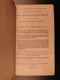
Sold20211784 CAPTAIN JAMES COOK VOYAGES AROUND THE WORLD 150[COOKS VOYAGES] First Edition. A New, Authentic, and Complete Collection of Voyages Round the World. Undertaken and Performed by Royal Authority. Containing an Authentic, Entertaining, Full and CompleSee Sold Price
Sold2022COOK, JAMES The Three Voyages of Captain James Cook Round the World.COOK, JAMES The Three Voyages of Captain James Cook Round the World. London: Longman, Hurst, Rees, Orme, and Brown, 1821. Seven volumes in period brown calf, rebacked to style, all edges marbled. 8 5/See Sold Price
Sold20191786 VERY RARE Voyages of Captain James Cook Hawaii1786 VERY RARE Voyages of Captain James Cook Hawaii Pacific Australia New Zealand “Remember, the greater the opportunity, the fewer are those who see it.” – James Cook James Cook was an 18th-cenSee Sold Price
Sold20211793 Captain James Cook Third Pacific Voyage1793 Captain James Cook Third Pacific Voyage Illustrated Nootka Sound Hawaii “Remember, the greater the opportunity, the fewer are those who see it.” – James Cook James Cook was an 18th-centurySee Sold Price
20201794 Voyages of Captain James Cook Australia1794 Voyages of Captain James Cook Australia New Zealand Hawaii Pacific Berenger “Remember, the greater the opportunity, the fewer are those who see it.” – James Cook James Cook was an 18th-centSee Sold Price
5 days LeftHunt and Peck Estate Services, Inc.1784 Captain James Cook "A Voyage to the Pacific Ocean" 2 of 3 volumes$360(2 bids)
Jun 02Schilb Antiquarian Rare Books1880 Captain James Cook Voyages Hawaii Pacific Australia Kippis South Sea Navy$1
7 days LeftTrillium Antique Prints & Rare BooksWebber & Cook, Rare - View of the Harbour of Taloo, in the Islands of Eimeo$500
7 days LeftTrillium Antique Prints & Rare BooksWebber & Cook, Rare - A Toopapaoo of a Chief, with a Priest Making His Offering to the Morai, in$500
May 16Zikorn Arts & History ObjectsCentral America West Coast 1855 British Admiralty Nautical Chart$100(1 bid)
5 days LeftHunt and Peck Estate Services, Inc.1891 James Burney "History of the Buccaneers of America"$50
4 days LeftJasper52Central America Caribbean Gulf of Mexico chart Ports lighthouses LARGE 1918 map$45
11 hrs LeftMynt AuctionsPatrick Reed signed "Captain America" 2018 Le Golf National Pin Flag-JSA AF18960$10
4 days LeftMynt AuctionsPatrick Reed signed "Captain America" 2018 Le Golf National Pin Flag-JSA AF18962$10
4 days LeftJasper52West India Islands & Caribbean Sea Sheet 2 ADMIRALTY sea chart 1913 (1949) map$120
14 hrs LeftWoodcliff on The Hudson13 Captain America Comic Books from the 12c and 15c Era$300(6 bids)
14 hrs LeftWoodcliff on The HudsonThree Silver Age 12c Captain America Comic Books Including #100$175(5 bids)
May 19Heartland Artifact Auctions IncHaida Pipe, From Oregon / NW Coast USA. Finely crafted early artwork from the late 1800's - early$12(2 bids)
May 12Ararity AuctionsAntique 19thC American Needlepoint Sampler Family of Captain James Shepard$25(1 bid)


![Vancouver: Antique Chart of Northwest Coast of America: Title/Content of Map: A Chart Shewing Part of the Coast of N.W. America, with the Tracks of His Majesty's Sloop Discovery and Armed Tender Chatham . . . [Columbia River to Northern California] Date Pr](https://p1.liveauctioneers.com/5584/114563/58815189_1_x.jpg?height=310&quality=70&version=1514941693)


![1784 CAPTAIN JAMES COOK VOYAGES AROUND THE WORLD 150: [COOKS VOYAGES] First Edition. A New, Authentic, and Complete Collection of Voyages Round the World. Undertaken and Performed by Royal Authority. Containing an Authentic, Entertaining, Full and Comple](https://p1.liveauctioneers.com/5584/216935/111250719_1_x.jpg?height=310&quality=70&version=1631047725)