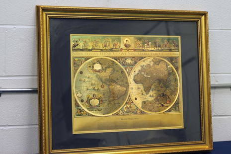
Sold2023Framed Gold Foil World MapNova Totivs Terrarum Orbis Geographica Tabula Gold Foiled World Map in a Gilt Frame. Approx. 25"H x 29"L. Photo has not been examined out of frame. Photos are considered part of the conditionSee Sold Price
Sold2021VINTAGE GOLD FOIL 1630 ANTIQUE WORLD MAPVINTAGE GOLD FOIL 1630 ANTIQUE WORLD MAP "Nova Totius Terrarum Orbis Geographica Ac Hydrographica TAbvla" Print, Framed. Size: 23 X 19 inches. Private Collection.See Sold Price
Sold2017de la Tour: Antique Map of World; Twin Hemispheres 1777Title/Content of Map: 'Mappemonde' World twin hemispheres Date Printed: 1777 Image Size: Approx 18.5 x 16.5cm, 7.25 x 6.25 inches (Medium); Please note that this is a folding map. Type: Antique copperSee Sold Price
Sold2019ORBIS TERRARUM TYPUS DE INTEGROIN PLURIMIS WORLD MAPHuge 40" x 30" Framed Gold Foil Map 1660 Nicolaus Visscher Orbis Terrarum Print. Actual map is 21" x 31"See Sold Price
Sold2017Bonne: Antique Map of the World in Hemispheres, 1780Title/Content of Map: 'L'Ancien Monde et le Nouveau en Deux Hemispheres' A map of the world in twin hemispheres Date Printed: 1780 Image Size: Approx 23.5 x 43.5cm, 9.25 x 17.25 inches (Large); PleaseSee Sold Price
Sold2018Johnston: Antique Map of World Precipitation, 1906TITLE/CONTENT OF MAP: 'The distribution of Rain and Snow. Over The Globe' WORLD PRECIPITATION. Rainfall. Limit of Snowfall. Snowline. DATE PRINTED: 1906 IMAGE SIZE: Approx 20.0 x 26.0cm, 8 x 10.25 incSee Sold Price
Sold2017de la Tour: Antique Map of the Ancient World, 1777Title/Content of Map: 'Le Monde connu des Anciens' Date Printed: 1777 Image Size: Approx 18.5 x 16.5cm, 7.25 x 6.25 inches (Medium); Please note that this is a folding map. Type: Antique copperplate mSee Sold Price
Sold2022World War 1. Eastern Front, 1914. Army Concentration Areas 1959 old mapTITLE/CONTENT OF MAP: 'Eastern Front, 1914 - Army Concentration Areas // General Map - Eastern Front' DATE PRINTED: 1959 IMAGE SIZE: Approx 25.0 x 33.0cm, 9.75 x 13 inches (Large) TYPE: Antique colourSee Sold Price
Sold2024World War 2. Opening Japanese Offensive 1941. Pearl Harbor Malaya 1959 old mapTITLE/CONTENT OF MAP: 'The War with Japan - Opening Operations of Japanese Offensive' DATE PRINTED: 1959 IMAGE SIZE: Approx 25.0 x 32.5cm, 10 x 12.75 inches (Large) TYPE: Antique colour military map CSee Sold Price
Sold2024World War 2. Planned expansion of Japanese Empire 1959 old vintage map chartCAPTION PRINTED BELOW PICTURE: 'The War with Japan - Contemplated Expansion of Japanese Empire' DATE PRINTED: 1959 IMAGE SIZE: Approx 25.0 x 32.0cm, 9.75 x 12.75 inches (Large) TYPE: Antique colour miSee Sold Price
Sold2023World's highest waterfalls & biggest lakes. HUGHES 1876 old antique map chartTITLE/CONTENT OF MAP: 'Waterfalls. Lakes' DATE PRINTED: 1876 IMAGE SIZE: Approx 25.0 x 30.5cm, 9.75 x 12 inches (Large) TYPE: Antique hand coloured engraved map CONDITION: Good; suitable for framing.See Sold Price
Sold2023General Chart on Mercators Projection. World. Cook's route. PAYNE 1798 old mapTITLE/CONTENT OF MAP: 'General Chart on Mercators Projection' DATE PRINTED: 1798 IMAGE SIZE: Approx 18.0 x 25.0cm, 7 x 9.75 inches (Medium) TYPE: Antique copperplate engraved map with original hand coSee Sold Price
Sold2017TWO ANTIQUE BENTWOOD EASELS & MAP PRINTSEasels measure approx. 21 1/8" w x 55 3/4" h. Maps are vintage reproductions of the World & Europe compliments of Sanka Coffee.See Sold Price
Sold2020Framed Blaeu Wall Map Gold FoilFramed Blaeu Wall Map Gold Foil Roughly 25.5" x 32"See Sold Price
Sold2018Hand Colored Map of the World, Willem BlaeuWillem Blaeu, (Dutch, 1571-1638) "Nova Totius Terrarum Orbis Geograhica ac Hydrographica" originally published 1606 Nice old color example of Blaeu's classic world map Approx. 19.5" x 25.5" (unframed)See Sold Price
Sold2017Large 3 Paneled Antique Gold Gilt MirrorLarge 3 Paneled Antique Gold Gilt Mirror measuring approx. 25"h x 63"wSee Sold Price
Sold2017Cape Verde Islands Bellin, 1758 MapCarte Des Isles Du Cap Verd'. Cape Verde Islands. Bellin, 1758 Antique Map. Size: Approx 23.5 x 30.0cm, 9.25 x 11.75 inches; Please note that this is a folding map. Antique 18th century copperplate maSee Sold Price
Sold2024Antique Gold Filled Heart LocketAntique gold filled heart locket with etched radiating pattern and monogram to reverse. Interior contains antique photograph. Measures approx. 1.25 x 1 inches. Some surface wear including scratching oSee Sold Price
Sold2018Arrowsmith: Antique Map of Ancient Germany, 1828TITLE/CONTENT OF MAP: 'Germania; Vel Regiones intra Rhenum f1. Oceanum, Sinum Codanum, Vistulam f1. Montes Sarmaticos et Danubium f1. Sitae' DATE PRINTED: 1828 IMAGE SIZE: Approx 25.5 x 28.5cm, 10 x 1See Sold Price
Sold2024WESTERN ASIA IN 1600 AD. under the Turks & Persians 1902 old antique map chartTITLE/CONTENT OF MAP: 'Western Asia under the Turks & Persians A.D. 1600; Inset map of Southern Arabia' DATE PRINTED: 1902 IMAGE SIZE: Approx 25.0 x 33.0cm, 9.75 x 13 inches (Large) TYPE: Antique coloSee Sold Price
Sold2021Antique World Map 1826Antique World Map. Size: 11 X 16 inches approx. Unframed. Printed Circa 1826. Centerfold as issued.See Sold Price
2018THE SHETLAND ISLANDS. Scotland. Edward WELLER. DispatchTITLE/CONTENT OF MAP: 'The Shetland Islands' DATE PRINTED: 1863 IMAGE SIZE: Approx 25.0 x 32.0cm, 9.75 x 12.5 inches (Large) TYPE: Antique map with original outline colour CONDITION: Good; suitable foSee Sold Price
Sold2015Antique 14K Gold and Turquoise Cameo BroochAn antique cameo set in 14K yellow gold, 5.4 dwt. approx. 1.25" x 1" Condition vg/gSee Sold Price
May 26Ararity AuctionsThomson's 1817 Hand Colored Map Comparative Heights of the World's Great Mountains$50
1 day LeftJasper52Empire Romain sous Constantin et sous Trajan. Roman Empire. MALTE-BRUN c1871 map$30
1 day LeftJasper52Countries round the Mediterranean. Soundings Telegraph cables. STANFORD 1894 map$75
1 day LeftJasper52Countries round the Mediterranean. Soundings Telegraph cables. STANFORD 1894 map$75