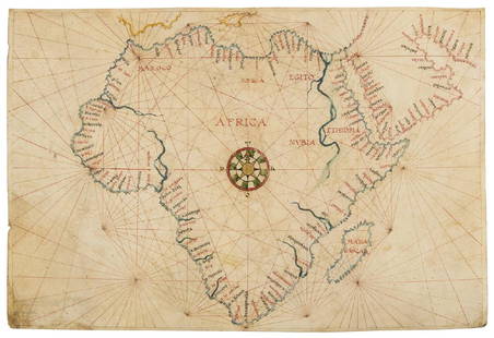
Sold2019Africa.- Agnese (Manner of Battista, c.1500-1564)Africa.- Agnese (Manner of Battista, c.1500-1564) Portolan chart of Africa and the Arabian Peninsula, large compass rose with port towns and cities annotated, pen and inks, watercolour wash, heighteneSee Sold Price
Sold2021MAP, Western Hemisphere, BlaeuBlaeu's Stunning Carte-a-Figures Map of the Americas in Full Contemporary Color. Western Hemisphere - America. Willem Blaeu, Americae Nova Tabula, 1642 (circa). Hand Color. This stunning carte-a-figurSee Sold Price
Sold2022Scarce Texas map (western part) from Asher & AdamsLarge double-page map of Western Portion of Texas with inset of extreme western tip of the state. Shows towns, proposed railroad lines and river, including the Colorado River and the Rio Grande. The fSee Sold Price
Sold2019MAP - Western Mexico. MercatorWestern Mexico. Mercator/Hondius, Hispania Nova, 1613 (published). Hand Color. Lovely small map of central and western Mexico. It locates many cities and features including Mexico City on the shore ofSee Sold Price
Sold2023Hayden Chromolithogaph Geological Map, Western Colorado and Part of UtahHAYDEN, Ferdinand Vandeveer (1829-1887). Western Colorado and Part of Utah. Chromolithograph. New York: Julius Bien, 1877. From "Geological and Geographical Atlas of Colorado and Portions of AdjacentSee Sold Price
Sold2023MAP, Western Hemisphere, Robert de VaugondyWestern Hemisphere - America. Didier Robert de Vaugondy, L'Amerique, from Nouvel Atlas Portatif, 1778 (circa). Hand Color. This handsome small map of the Americas is sparsely detailed, but interestingSee Sold Price
Sold2021Tallis, John (Pub) 1852 Map. Western HemisphereSteel Engraved Map with Original Outline Hand Color Published 1852-56 by John Tallis, London for "The Universal Pronouncing Dictionary" by Thomas Wright. Drawn & Engraved by John Rapkin. Centre fold aSee Sold Price
Sold2022Thomas Bowen,1778, Map, Western Atlantic Ocean"Thomas Bowen, London 1778, A New & Accurate Chart of the Western or Atlantic Ocean Drawn from Surveys and most approved Maps & Charts" by Thomas Bowen. Hand colored, modern framing. Dimensions:SightSee Sold Price
Sold20191872 Warner Beers Map Western Portion of SouthernReserve Reduced! Title/Content of Map: 1872 Warner Beers Map Western Portion of Southern States -- County Map of Tennessee, Kentucky, Alabama. Mississippi, Arkansas and Louisiana Date: 1872, Chicago CSee Sold Price
Sold2024Taylor, Ruth 1935 Vintage Cartoon Map. Western HemisphereVintage Lithograph Map Published 1935, Boston for "Our U. S. A. A Gay Geography" By Frank Taylor. Maps by Ruth Taylor. Paper Size: 12.5 x 9.5 inch (32 x 24cm) Tight margin as split from the larger sheSee Sold Price
Sold2022Barclay, James C1800 Hand Col Map. Western Hemisphere"The New World or Western Hemisphere" Hand Colored Copper Engraved Map Published C1800 Halifax & Newcastle, England for "Barclay's Universal English Dictionary…" by James Barclay. Maps Engraved by CSee Sold Price
Sold2018Map Western Indias and Central America 1860 AdolfTitle/Content of Map: Map Western Indias and Central America 1860 Adolf Stieler, Copper etching Date: 1860 Cartographer: Adolf Stieler (1775-1836) Material/Medium: Copper etching Size: Leaf Dimension:See Sold Price
Sold2021Pinnock & Archer 1833 Map. Western HemisphereWoodblock Published 1833, London for "The Guide to Knowledge" Edited by W. Pinnock. Maps by Joshua Archer. Reverse side blank. Paper Size: 10.5 x 7.5 inch (27 x 19cm) Good ConditionSee Sold Price
Sold2021Thomson, John (Pub) 1825 Map. Western HemisphereCopper Engraved Map Published 1825 by John Thomson, Edinburgh for "The Edinburgh School Atlas" by N. R. Hewitt. Maps Engraved by Hewitt. Engraved Vignette in corner. Original Outline Hand Colour. RareSee Sold Price
Sold2021Tallis, John (Pub) 1852 Map. Western AfricaSteel Engraved Map with Original Outline Hand Color Published 1852-56 by John Tallis, London for "The Universal Pronouncing Dictionary" by Thomas Wright. Drawn & Engraved by John Rapkin. Centre fold aSee Sold Price
Sold2023Thomson, John (Pub) 1825 Map. Western Hemisphere (Faults)Copper Engraved Map Published 1825 by John Thomson, Edinburgh for "The Edinburgh School Atlas" by N. R. Hewitt. Maps Engraved by Hewitt. Original Outline Hand Colour. Rare. Paper Size: 10.5 x 8 inch (See Sold Price
Sold2022Times Atlas 1895 Map. Western & Eastern HemisphereLithograph Maps Published 1895, London for "The Times Atlas" Centre fold as published. Paper Size: 21.5 x 16.5 inch (55 x 42cm) Good ConditionSee Sold Price
Sold2023Cary Antique Maps, Western European (4)Set of 4 maps including Europe, France, Netherlands, Portugal. John Cary, London, early 19th C. Hand-colored engravings. Center vertical folds, as issued.See Sold Price
Sold2021Boating maps, western New Providence, rose island,Maps from 1981 tropic Isle publishers, Inc By Harry Kline, Western New Providence, rose Island, eastern approaches to Nassau harbour. Size 11“ x 17“See Sold Price
Sold2017Hondius: Antique Map of the Western Hemisphere, 1630Title/Content of Map: Western Hemisphere by H Hondius with sea monsters Date Printed: c1630-1634 Cartographer: Henricus Hondius Material/Medium: Paper Size: Approx 17" x 21" Magnificent Map. PublishedSee Sold Price
Sold20201846 1ed Mississippi Exploration Monette Indian Wars1846 1ed Mississippi Exploration Monette Indian Wars Color MAP Western Americana John Monette’s ‘History of the discovery and settlement of the valley of the Mississippi’ is the history of the ASee Sold Price
Sold2017Thomson: Antique Map of the Western Hemisphere, 1817Title/Content of Map: 'Western hemisphere' North & South America. Polynesia. Date Printed: 1817 Image Size: Approx 55.0 x 52.5cm, 21.5 x 20.75 inches (Large); Please note that this is a folding map. TSee Sold Price
Sold2017Tallis/Rapkin: Map of West Australia, Swan River, 1851TITLE/CONTENT OF MAP: 'WESTERN AUSTRALIA,SWAN RIVER. Helpman Gregory Gray routes' Vignettes: Sheep shearing; Aboriginals; Perth, from Mount Eliza. Counties. This map is folding hence the centrefold liSee Sold Price
Sold2019WESTERN HEMISPHERE. Shows Russian America, GranTITLE/CONTENT OF MAP: 'Western Hemisphere' Alaska is indicated as "Russian America" as it was prior to its sale to the United States in 1867. The border between British North America (now Canada) andSee Sold Price
3 days LeftJasper52WORLD WAR 2. Siegfried & Maginot lines defences. Pre-invasion. Belgium 1940 map$25
3 days LeftJasper52WORLD WAR 2. Maginot & Siegfried lines defences. Pre-invasion. Belgium 1940 map$25
3 days LeftJasper52WORLD WAR 2. Maginot & Siegfried line defences. Pre-invasion of France 1940 map$25
3 days LeftJasper52WORLD WAR 2. Siegfried & Maginot line defences. Pre-invasion of France 1940 map$30
4 days LeftPotter & Potter AuctionsPOLAND, Edwin Christian (1903 – 1991). The Evergreen Playgr...$200
2 days LeftJasper521869 Mitchell Map of Much of Western Europe -- XXXII Prussia the German States Holland & Belgium$30
2 days LeftJasper521898 Rand McNally Map of Texas [verso] Indian Territory and Oklahoma -- Texas [verso] Oklahoma and$70
Featured3 days LeftJasper52Austro-Hungarian Monarchy (West) Vienna Austria. 50x60cm. JOHNSTON 1879 map$20
3 days LeftJasper52Spain, Portugal & Western France ports sea chart. Bordeaux Lisbon LARGE 1952 map$35
3 days LeftJasper52Spain, Portugal & Western France ports sea chart. Bay of Biscay. LARGE 1927 map$35
3 days LeftJasper52Spain, Portugal & Western France ports sea chart. Bordeaux Lisbon LARGE 1959 map$60
4 days LeftZikorn Arts & History ObjectsWest Indies, Western Cuba 1879 British Admiralty Nautical Map$100
3 days LeftJasper52Imperium Caroli Magni… Western Europe. Carolingian Empire. VAUGONDY 1752 map$100
4 days LeftPotter & Potter AuctionsSTORM, Mark. Official Texas Brags Map of North America. 194...$200(1 bid)


![1898 Rand McNally Map of Texas [verso] Indian Territory and Oklahoma -- Texas [verso] Oklahoma and (1 of 2)](https://p1.liveauctioneers.com/5584/328338/176911581_1_x.jpg?height=282&quality=70&version=1715113718)


