Sold2022AN AMERICAN CIVIL WAR ERA MAP, "United States of North America (Eastern & Central)," LONDON,AN AMERICAN CIVIL WAR ERA MAP, "United States of North America (Eastern & Central)," LONDON, 1861-1873, THEODORE ETTLING (b. 1823), hand colored lithograph on paper, by T. Ettling, published by CasselSee Sold Price
Sold2017Civil War Era Map of the United StatesUnited States. Taliaferro Preston Shaffner (1811 – 1881). Lithographed Map. London: Schaffner, 1862. 12 1/4 x 18 1/2 inchesSee Sold Price
Sold2017Civil War Era Map of the United StatesMap of the United States and Territories. Henry F. Walling (1825 - 1889) & Ormando W. Gray (fl. 1860 – 1880). Lithographed Map. Boston, 1871. 17 x 25 1/2 inches sheetSee Sold Price
Sold2021CIVIL WAR-ERA JOHNSON'S MILITARY MAP UNITED STATESFramed engraving with color on paper, "Johnson's New Military Map of the United States, Showing the Forts, Military Posts & c., with Enlarged Plans of Southern Harbors from Authentic Data Obtained atSee Sold Price
Sold20182 Colton Civil War Maps, Military Stations & Forts, 3Two (2) Colton Civil War maps, 3 items total. 1st item: J.H. Colton, Civil War era map of the United States showing Military Stations and Forts, prepared for The Rebellion Record, New York: G.P. PutnaSee Sold Price
Sold20221893 Government Map of Civil War Era United States -- Map of the United States of America ShowingTitle: 1893 Government Map of Civil War Era United States -- Map of the United States of America Showing the Boundaries of the Union and Confederate Geographical Divisions and Departments CartographerSee Sold Price
Sold20221893 Government Map of Civil War Era United States -- Map of the United States of America ShowingTitle: 1893 Government Map of Civil War Era United States -- Map of the United States of America Showing the Boundaries of the Union and Confederate Geographical Divisions and Departments; Plate CLXIVSee Sold Price
Sold20221893 Government Map of Civil War Era United States -- Map of the United States of America ShowingTitle: 1893 Government Map of Civil War Era United States -- Map of the United States of America Showing the Boundaries of the Union and Confederate Geographical Divisions and Departments; Plate CLXIISee Sold Price
Sold20221864 Civil War MAP United States Statistics Commerce1864 Civil War MAP United States Statistics Commerce American Trade Gold Silver The United States Department of Treasury published this Civil War-era report analyzing the commerce of the US GovernmentSee Sold Price
Sold2022Significant United States map, 1864 Johnson & WardVery interesting hand-colored map created at a pivotal time in the settlement of the American West. In this lovely Civil War era map many of the western states have still not settled their borders. ArSee Sold Price
Sold2019United States. Civil war era military map. ShowingTitle/Content of Map: United States. Civil war era military map. Showing southern ports Date: 1863 Cartographer: By Johnson & Ward. From, Johnson’s New Illustrated Family Atlas Size: 18x 26 1/4”.See Sold Price
Sold2023Civil War era map of North America from S. A. Mitchell Jr.Wonderful map of the North American continent with 1860 date but published in the 1863 Mitchell New General Atlas. Shows the United States at the height of the Civil War. Depicts the North American coSee Sold Price
Sold2017Ettling: Map of United States of North America, 1860United States of North America (Eastern & Central) T. J. Ettling, c1860 17 x 25. This great Civil War era map covers the country from the Rocky Mountains to the Atlantic seaboard. The map is engravedSee Sold Price
Sold20181864 Johnson Map of the United States -- Johnson'sTitle/Content of Map: 1864 Johnson Map of the United States -- Johnson's United States Date: 1864, New York Cartographer: A Johnson Size: 16.9 x 23.1 in. This is a large, highly detailed Civil War eraSee Sold Price
Sold20221864 Civil War era American Commerce Reports Trade Import HUGE MAP Railroads1864 Civil War era American Commerce Reports Trade Import HUGE MAP Railroads Statistics of the Foreign and Domestic Commerce of the United States is a mid-19th-century report on the values of goods anSee Sold Price
Sold20191866 MAPS Atlas Appleton Companion Travel Handbook1866 MAPS Atlas Appleton Companion Travel Handbook Geography United States Color A rare and finely illustrated atlas companion by Richards and Appleton. This Civil War-era work features four enormousSee Sold Price
Sold2022JOHN TALLIS (1817-1876) AN AMERICAN CIVIL WAR MAP, "United States," LONDON, CIRCA 1863,JOHN TALLIS (1817-1876) AN AMERICAN CIVIL WAR MAP, "United States," LONDON, CIRCA 1863, hand-colored lithograph on wove paper showing, "Federal, Non Slave Holding States (Red); Border, Slaveholding (BSee Sold Price
Sold20241835 United States Capped Bust Half DimeRare, pre Civil War era united states half dime or 5 cent silver coin. Shows wear but, a scarce coin, see photosSee Sold Price
Sold20191868 1ed SIGNED Lieutenant Flagler Union Army Civil War1868 1ed SIGNED Lieutenant Flagler Union Army Civil War New York Officers Register This Civil War-era United States register was a complete list of Union Army officers from the state of New York. EachSee Sold Price
Sold2019Colton's Civil War map of the United States 1862Heading: (Maps) Author: Colton, J.H. Title: Colton's United States Showing the Military Stations, Forts &c. Place Published: New York Publisher: Date Published: 1862 Description:See Sold Price
Sold2021Civil War Geographical Boundary mapDefinitive map of the geographical boundaries between the Union and Confederate armies. Opens a window into the state of the U. S. during the height of the Civil War. “Map of the United States oSee Sold Price
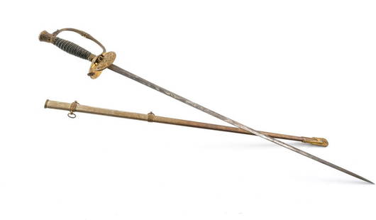
Sold2022M1860 U.S. Army Officer's Dress SwordU.S. Civil War era Model 1860 United States Army Officer's Dress Sword. Produced by Ridabock & Co. of New York. Includes metal scabbard. Patina / oxidation and wear as expected. Slightly loose in fittSee Sold Price
Sold2022Civil War Military map - scarce territorial bordersThe Johnson and Ward atlas company produced two memorable, double-page Civil War maps of the United States. This is the more desirable issue, showing the state and territory borders instead of the MilSee Sold Price
Sold2022Scarce Civil War Era 35-Star Halo Pattern United States FlagScarce Civil War Era 35-Star Halo Pattern United States Flagcirca 1863-1865, cotton print, commemorating the July 4, 1863 addition of West Virginia to the Union. The flag, 20 x 28 in., is presented inSee Sold Price
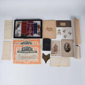
4 days LeftEarly American History Auctions1863 JOHN ARCHIBALD CAMPBELL ALS Re: a Friends Prisoner Exchange Confederate Asst. Secretary of War$450
2 days LeftWeatherham Estate TreasuresAbraham Lincoln Bronze Bust Sculpture On Marble Base - Signed Original - 10lbs$400
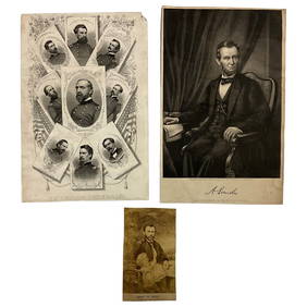
Jun 22Lakeshore Event CenterEphemera, Civil War Generals, Abraham Lincoln, Ulysses Grant, Lot of 3$30(1 bid)
Jun 23Schilb Antiquarian Rare Books1890 1ed Confederate Memoirs of Joseph Johnston & Jefferson Davis Civil War CSA$66(3 bids)
Jun 23Schilb Antiquarian Rare Books1860 Political Textbook 1ed SLAVERY Abe Lincoln Douglass Civil War Government$7(3 bids)
Jun 15Bazaar of PersiaUS Half dollar 1922 100th anniversary Birth of Ulysses S. Grant Silver coin$400
4 days LeftEarly American History AuctionsAbraham Lincoln 1864 Message from the President of the United States Ship Illegally Captured in 1862$150(1 bid)
4 days LeftEarly American History Auctions1865 Treasury Department Circular, Canal Boats Doing Business With Indian Tribes Are Exempt From Tax$220
Jun 23Schilb Antiquarian Rare Books1918 Robert E Lee Civil WAR Confederate General CSA Battles MAPS Illustrated$9(3 bids)
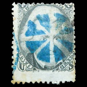
4 days LeftHolabird Western Americana CollectionsJefferson Davis Confederate Stamp Sheet, Scott 11 [179366]$750
4 days LeftEarly American History AuctionsAbraham Lincoln Gettysburg Address on Muslin Cotton Fabric measuring 21.5 x 15.5$100
4 days LeftEarly American History Auctions1905 Civil War General OLIVER OTIS HOWARD Typed Letter Signed as President of the Lincoln Memorial$300
4 days LeftSimpson Galleries, LLC.JULIUS BIEN (1826-1909) AN AMERICAN CIVIL WAR RECONNAISSANCE MAP, "Map of Texas and Part of New$100
4 days LeftEarly American History AuctionsLot of 47 Civil War Prints of the First U.S. Ironclad St. Louis or Baron de Kalb and 5 Iron Caltrops$750
4 days LeftEarly American History Auctions1862 Civil War Dated, Union General David Hunter Autograph Letter Signed Involving 3 Union Generals$600
Jun 20Weatherham Estate TreasuresLarge Abraham Lincoln Bust Sculpture - President of the United States - (18.9lbs)$1,400
2 days LeftActivity AuctionsUSA President ABRAHAM LINCOLN HAIR lock Signed COA letter memorabilia relic USA$500


![Jefferson Davis Confederate Stamp Sheet, Scott 11 [179366] (1 of 1)](https://p1.liveauctioneers.com/2699/331499/178846702_1_x.jpg?height=282&quality=70&version=1717095214)