Sold2017William Darton, (10) antique mapsWilliam Darton, (10) antique maps, William Darton (British, 19th c.), "The Western Hemisphere or New World", "South America", etc., 12.75"h x 10.5"w (sheet), unframed Provenance: Property from a majorSee Sold Price
Sold2018Weller: Antique Map of Western British India, 1863TITLE/CONTENT OF MAP: 'India the Western States (Scinde Gujerat &c.)' DATE PRINTED: 1863 IMAGE SIZE: Approx 43.5 x 32.5cm, 17.25 x 12.75 inches (Large) TYPE: Antique map with original outline colour CSee Sold Price
Sold2019BRITISH INDIA. 'The Punjab Cashmere &c.' Kasmir.TITLE/CONTENT OF MAP: 'India the Punjab Cashmere &c.)' DATE PRINTED: 1863 IMAGE SIZE: Approx 31.0 x 44.0cm, 12.25 x 17.5 inches (Large) TYPE: Antique map with original outline colour CONDITION: Good;See Sold Price
Sold2016Antique Map, A New Map of the County of CornwallC. Smith (British, 19th century), "A New Map of the County of Cornwall Divided into Hundreds," 1804, hand-colored copper engraved map, published in Smith's New English Atlas, with the Jones & Smith scSee Sold Price
Sold2021Antique Jain Pilgrimage Painting (Tirtha Pata), 96'' xA Jain pilgrimage painting (Tirtha Pata) map of the sacred site Shatrunjaya, Gujurat, India, late 19th C. Pigment on cloth. Size: 96'' x 67'' (244 x 170 cm).See Sold Price
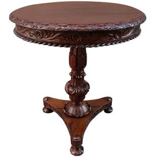
Sold202119th C British Colonial Rosewood Occasional TableA British Colonial Regency solid rosewood table made in India, circa 1830, featuring an elaborately carved apron and tripod pedestal base with bun feet.See Sold Price
Sold2023ANTIQUE EAST INDIA ISLANDS C 1840 MAPAntique East India Color Lithograph Map c. 1840 by a British Mapmaker. Purchased at Wattis Fine Art, Hong Kong. Professionally framed and matted. In frame measures 23.25"x22.25"x1.25" Weight 7 pds. PRSee Sold Price
Sold2023Tallis, John (Pub) 1854 Antique Map. British IndiaSteel Engraved Map Published 1853-4 by John Tallis, London for "The Life and Times of the Late Duke of Wellington" by Thomas Gaspey. Drawn and Engraved by J. Rapkin. Folds as issued. Paper Size: 13.75See Sold Price
Sold2021Rapkin, John 1858 Antique Map. British IndiaSteel Engraved Map Published 1858, London for "The History of the Indian Mutiny..." by Charles Ball. Centre fold as published. Drawn & Engraved by John Rapkin. Paper Size: 14 x 11 inch (36 x 28cm) GooSee Sold Price
Sold2024Rapkin, John 1860 Antique Map. British IndiaSteel Engraved Map Published 1860 by The London Printing & Published Company, London for "The Royal Dictionary-Cyclopedia for Universal Reference" by Thomas Wright. Drawn & Engraved by John Rapkin. FoSee Sold Price
Sold202219th C British Landscape Oil on Board Signed Roger19th C Antique British Oil on Board Signed Roger, Coastal Landscape. Board measures 7.25 inches H x 10.5 W.See Sold Price
Sold2017Tallis/Rapkin: Antique Map of British India, 1858Title/Content of Map: 'British India' Railways. Military bases. Mutiny events. Date Printed: 1858 Image Size: Approx 33.5 x 25.5cm, 13.25 x 10 inches (Large) Type: Antique steel engraved map with origSee Sold Price
Sold2017Thomson: Antique Map of British India, 1814Map: British India Southern Part/British India Northern Part Cartographer: Thomson Place & Date: Edinburgh / 1814/1817 Size: 24 1/8" x 22 5/8" Condition: overall age-toning and spotting; repaired spliSee Sold Price
Sold2017J Rapkin - Antique Map of British IndiaItem: J Rapkin - Antique Map of British India Description: Antique map of British India drawn and engraved by J Rapkin. Dimensions: 14.5x11 Please note that this lot has a confidential reserve. When ySee Sold Price
Sold2018Sidney Hall: Antique Map of British India & AfghanistanTITLE/CONTENT OF MAP: 'Hindustan, with part of Caubul' British India & Afghanistan. DATE PRINTED: 1856 IMAGE SIZE: Approx 41.0 x 28.5cm, 16 x 11.25 inches (Large) TYPE: Antique atlas map with originalSee Sold Price
Sold2018Weller: Antique Map of British India, 1863TITLE/CONTENT OF MAP: 'India the North West Provinces and Oude' Dehli. Nepal. DATE PRINTED: 1863 IMAGE SIZE: Approx 31.5 x 44.5cm, 12.5 x 17.5 inches (Large) TYPE: Antique map with original outline coSee Sold Price
Sold202319th Century British School, 'East India Company Ship, Bombay'. Oil on Canvas19th Century British School, 'East India Company Ship, Bombay'. Oil painting on canvas depicting a steam/sailing ship, in gilt moulding. Provenance: Christies, London, November 17,1961, Lot # 56. EastSee Sold Price
Sold2023Highly collectible 1860 RR map of Texas, S. A. Mitchell, Jr.One of the most attractive atlas maps of Texas to appear in the mid-19th century. This authentic antique map (160 years old) was published when the Civil War was at its height. It shows the region froSee Sold Price
Sold202419th C. Albumen Photographs, British Colonial India (116)19th Century Album of British Colonial India Albumen Prints. Collection of approximately 116 mounted albumen prints housed in a hardcover leather bound album, titled INDIA. Images of People, Hunting SSee Sold Price
Sold2017Colton: Antique Map of Hindostan or British India, 1861Map: Colton's Hindostan or British India Date Printed: 1861 Cartographer: J. H. Colton Material/Medium: Paper Size: 17 1/4" x 14" Condition: Excellent Hand colored, steel engraved. Printed in New YorkSee Sold Price
Sold2019Johnson & Ward, "Hindostan or British India," 19th c.,Johnson & Ward, "Hindostan or British India," 19th c., hand colored, H.- 12 1/2 in., W.- 16 1/2 in.See Sold Price
Sold2023Oil Painting Portrait Bay Hunter Horse In Stable By Albert Clark Snr 1821-1909Oil Painting Portrait Bay Hunter Horse In Stable By Albert Clark Snr 1821-1909 1 Fine Antique British 19th Century Wall Art Oil Painting Portrait Of A Bay Hunter Horse In Stable By Listed Albert ClarkSee Sold Price
Sold2020John Westall "River Valley Landscape" Antique OilJohn Westall (British, 19th C.) antique oil on canvas mounted to board depicting figures overlooking broad river valley landscape, signed lower right: "J. Westall." Image: 7.5" H x 15.25" W; frame: 12See Sold Price
Sold2023Antique 19th C. Map of East Los Angeles CountyAntique 19th Century panoramic map of East Los Angeles County, California, depicting a bird's-eye view from Los Angeles River looking towards the Sierra Madre Mountains. Printed by H.S. Crocker & Co.,See Sold Price
4 days LeftMynt AuctionsPair of 19 Century French Orientalism Bronze Statues by Marcel Debut$10(1 bid)
Featured2 days LeftJasper521830 SCENES in ASIA AMERICAN ED. antique illustrated ARMENIA CHINA JAPAN SIBERIA$120
3 days LeftJasper52Carte des Anciens Glaciers de la Suisse #3 W Switzerland & Haute-Savoie 1883 map$300
2 days LeftJasper521804 MAP of CENTRAL ASIA MANCHURIA TIBET RUSSIA UZBEKISTAN MONGOLIA AFGHANISTAN$70
2 days LeftJasper52BRITISH SPORTS and SPORTSMEN antique STORY of SHIPPING ILLUSTRATED MASSIVE FOLIO$120
2 days LeftJasper521839 NARRATIVE of JOURNEY TO THE SITE of BABYLON by C. RICH antique ILLUSTRATED$260
2 days LeftJasper521910 TRANS-HIMALAYA DISCOVERIES & ADVENTURES in TIBET antique ILLUSTRATED 3 vols$480
3 days LeftJasper52Hydrographical chart of the world… Wright/Mercator's Projection THOMSON 1817 map$260
3 days LeftJasper52New Holland & Asiatic islands Australia New Zealand Melanesia THOMSON 1817 map$320