Sold2017Jefferys: Antique Sea Chart Map of Coast of France 1774Map: 4th Chart of the Coast of France from Callais to Fecamp Date Printed: 1774 Cartographer: Jefferys, Thomas Size: 8 x 11 Condition: Very good Uniformly browned chain-laid paper. Strong impression.See Sold Price
Sold2022Scilly Isles.- Collins (Capt. Greenville) The IslandsScilly Isles.- Collins (Capt. Greenville) The Islands of Scilly, sea chart with decorative cartouche in the upper left corner, compass rose and numerous rhumb lines, with the separately printed letterSee Sold Price
Sold2017Ferrer: Antique Nautical Chart of Norman Island, 18091809 Nautical Chart of Norman Island BVI (Treasure Island). Original engraving from José Joaquín de Ferrer y Cafranga's sea atlas, the 'Portulano de los Estados Unidos', published in Madrid in 1818.See Sold Price
Sold2017Mount & Page: Antique Coast Profile of Ireland, 1749Title/Content of Map: '[A description of the sea coast of Ireland]' The following places are shown or referred to on the coastal profile chart: Galloway (Galway) Aran Islands Limerick Date Printed: 17See Sold Price
Sold2017Ferrer: Antique Nautical Chart of St. Mary's, 18091809 Nautical Chart of St. Mary's & Cumberland Island, Georgia. Original engraving from José Joaquín de Ferrer y Cafranga's sea atlas, the 'Portulano de los Estados Unidos', published in Madrid in 1See Sold Price
Sold2017Mount & Page: Antique Coast Profile Ionian Islands 1747How these lands appear at sea' Ionian islands coast profile. The following places are shown or referred to on the coastal profile chart: Corfu Fanu Pachsu (Paxos) Antipaschu (Antipaxos) Marco ZephelonSee Sold Price
Sold2017Ferrer: Antique Nautical Chart of Nassau River, 18091809 Nautical Chart of Nassau River and Part of Amelia Island and Talbot Island (Florida). Original engraving from José Joaquín de Ferrer y Cafranga's sea atlas, the 'Portulano de los Estados UnidosSee Sold Price
Sold2020Captain Collins Sea Chart of The River Thames andCaptain Greenville Collins (1643-1694), "The River of the THAMES from London to the Buoy of the Nore," London: British Coasting Pilot, 1693. This hand colored engraving sea chart map features the RiveSee Sold Price
Sold2018Lootsman / Jacobsz: Antique Sea Chart of Brazil, 1662Title/Content of Map: Pascaerte van Brasil van Rio de Maranhaon tot Rio de la Plata . . . Date Printed: 1662 Cartographer: Lootsman/Jacobsz Size: 21.5" x 16.5" Rare sea chart of Brazil, one of the earSee Sold Price
Sold2022Pieter Goos (1616-1675) - Antique Map of Celtic Sea - Antique Sea ChartPieter Goos (1616–1675). Accurate nautical chart of the Celtic Sea oriented north to the left. The title cartouche depicts Nereus and his children, the Nereids, with cross staffs and an astrolaSee Sold Price
2017van Keulen: Antique Sea Chart of South Hispaniola, 1682Map: Pas-kaart Van de Zuyd-Kust van Espanjola Cartographer: van Keulen Place & Date: Amsterdam / 1682 Size: 23" x 20" Condition: outline color (wash in cartouche); top margin trimmed close; light overSee Sold Price
Sold2020Antique Sea Chart of the Lesser AntillesAntique Sea Chart of the Lesser Antilles by Johannes Van Keule. Pas kaart Van de Caribes Tusschen I. Barbados en ts martin. Used condition. 31" x 28 1/2" tallSee Sold Price
Sold2018Antique Sea Chart Map of English Channel, 1914Title/Content of Map: 'The English Channel; Inset Newport; Dover; Calais; Tilbury; Brest; Cherbourg; Le Havre; Plymouth Sound; Southampton; Portsmouth; London Docks' sea chart. Ports lighthouses mailSee Sold Price
Sold20191794 Sea Chart of South Part Sumatra 18th Century Mapa very rare 18th century antique sea chart. This is an uncolored copper plate engraving. Image measures 24\" x 32.5\". This map has been matted and is ready for framing. A stunning chart of the southeSee Sold Price
Sold20181700 Pacific sea chart with Island of California andTitle: Mer de Sud ou Pacifique contenant l'Isle de Californe. Map maker: Pierre Mortier Place and Year: Amsterdam, 1700 Dimensions: 60 x 74.5 cm (23.6 x 29.3 in) Technique: Copperplate engraving ColorSee Sold Price
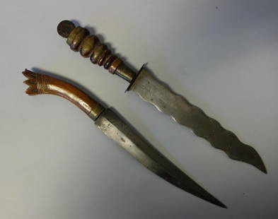
Sold20152 Ethnographic Daggers w/ Coin, South Sea IslandsTwo Antique South Sea Islands Ethnographic daggers. One dagger with carved wood handle, the top of the handle formed as a crown, 15" long. The second dagger having a wooden handle, with brass detailinSee Sold Price
Sold2021GOOS, PIETER - Caribbean Islands Sea Chart 1666GOOS, Pieter (1616-1675) . Pascaert Vande Caribes Eylanden. Amsterdam: 1666. Engraved sea chart, period hand-colouring in outline. Sheet size: 21 1/2 x 25 inches. Minor age toning. Fine seventeenth ceSee Sold Price
Sold2018Antique Chart of the Island of Tahiti, 1775Title/Content of Map: Chart of the Island of Otaheite Date Printed: 1775 ca. Cartographer: Capt. James Cook R.N. Size (inches): 12.3x16.1 Large scale map of the Island of Tahiti, with detailed typograSee Sold Price
Sold2021Nautical Map / Sea Chart, #362 Block Island Sound andDescription: Nautical Map / Sea Chart, United States East Coast, New York, Long Island, Block Island Sound and Gardiner's Bay, 6th edition, Feb 10/69; Shipping: $20; different rate to California, AlasSee Sold Price
Sold2024Puerto Rico Antique Maps (3)Group of 3 antique folding map sea charts. One of Puerto Rico. Another of San Juan Harbor. The third a composite including Mayaguez Bay. Washington, D.C.: 1899. All fold as issued.See Sold Price
Sold2019Virgin Islands Carribbean Sea ChartThe Virgin Islands from English and Danish Surveys by Thomas Jefferys. English map. Sight 18 1/2" x 24 1/2".See Sold Price
Sold2024Antique 1883 Eldridge's Chart Long Island SoundAntique 1883 Eldridge's Chart Long Island Sound From Newport to New York by Geo. Eldridge, Hydrographer and Published by S. Thaxter & Son. The map is framed in a metal map frame with no glass. The mapSee Sold Price
Sold2020Nautical Map / Sea Chart, #1212 Eastern Long IslandDescription: Nautical Map / Sea Chart, United States East Coast, Connecticut - New York, Long Island Sound, Eastern Part, 12th edition feb 10 / 69 ; all measurements are approximate; Folded; ShippingSee Sold Price
Sold2022Faroe Islands.- North Atlantic.- Keulen (Gerard van) Nieuwe afteekening van de Eylanden van Fero,Faroe Islands.- North Atlantic.- Keulen (Gerard van) Nieuwe afteekening van de Eylanden van Fero, scarce sea chart of the Faroe Islands with north oriented to the right, rhumb lines, compass roses, soSee Sold Price
4 days LeftJasper52Grand Bahama & Great Abaco Islands. Bahamas. ADMIRALTY sea chart 1886 (1968) map$140
4 days LeftJasper52Anguilla St. Martin/Maarten Barts. Caribbean. US Navy sea chart 1899 (1917) map$280
4 days LeftJasper52West India Islands & Caribbean Sea Sheet 2 ADMIRALTY sea chart 1913 (1949) map$120
4 days LeftJasper52Bahamas harbours Pelican Abaco Berry I Jumentos ADMIRALTY chart 1899 (1920) map$140
4 days LeftJasper52Barbuda Island. West Indies Caribbean. ADMIRALTY sea chart 1850 (1966) old map$120
Featured4 days LeftJasper52Dominica, British West Indies. Caribbean. US Navy sea chart 1892 (1917) map$140
4 days LeftJasper52Bahamas. San Salvador Crooked Rum Cay Mariguana ADMIRALTY chart 1892 (1919) map$140
4 days LeftJasper52Jamaica SE coast Morant-Portland Pt Kingston ADMIRALTY sea chart 1963 (1971) map$120
4 days LeftJasper52Jamaica & the Pedro Bank. South Cuba Haiti. ADMIRALTY sea chart 1866 (1968) map$120
4 days LeftJasper52Antigua Falmouth English Harbour West Indies ADMIRALTY sea chart 1954 (1968) map$280
4 days LeftJasper52Kingston approach Jamaica south coast Caribbean ADMIRALTY chart 1962 (1966) map$120
4 days LeftJasper52Venezuela Coast Trinidad Tobago Isla Margarita ADMIRALTY chart 1894 (1950) map$120
Featured4 days LeftJasper52Kingston Harbour Port Royal Jamaica Caribbean ADMIRALTY chart 1960 (1966) map$140
Featured4 days LeftJasper52The Bahamas, Cuba & Bermuda "or Summer Islands". THOMSON 1817 old antique map$190


![Mount & Page: Antique Coast Profile of Ireland, 1749: Title/Content of Map: '[A description of the sea coast of Ireland]' The following places are shown or referred to on the coastal profile chart: Galloway (Galway) Aran Islands Limerick Date Printed: 17](https://p1.liveauctioneers.com/5584/110608/56777156_1_x.jpg?height=310&quality=70&version=1507840413)