Sold2018Antique Chart of the Island of Tahiti, 1775Title/Content of Map: Chart of the Island of Otaheite Date Printed: 1775 ca. Cartographer: Capt. James Cook R.N. Size (inches): 12.3x16.1 Large scale map of the Island of Tahiti, with detailed typograSee Sold Price
Sold2024James Cook - Map / Chart Of The Island TahitiEngraved nautical map from the 1774 first French edition of the first map of New Zealand, illustrating Lieutenant James Cook's 1769 exploration of the passage between New Zealand's North and South islSee Sold Price
Sold2024Antique 1883 Eldridge's Chart Long Island SoundAntique 1883 Eldridge's Chart Long Island Sound From Newport to New York by Geo. Eldridge, Hydrographer and Published by S. Thaxter & Son. The map is framed in a metal map frame with no glass. The mapSee Sold Price
Sold2017Ferrer: Antique Nautical Chart of Norman Island, 18091809 Nautical Chart of Norman Island BVI (Treasure Island). Original engraving from José Joaquín de Ferrer y Cafranga's sea atlas, the 'Portulano de los Estados Unidos', published in Madrid in 1818.See Sold Price
Sold2023Antique Nautical Chart of Juan Fernandez Island: Northeast Side by English Pirate George Anson,1749Title: Antique Nautical Chart of Juan Fernandez Island: Northeast Side by English Pirate George Anson,1749 Date/Period: 1749 Materials: Copperplate engraved Size: 15 1/2 x 10” Explore the legendSee Sold Price
Sold2023Russell & Barclay C1825 Antique Map. Chart of the East India IslandsCopper Engraved Map Published C1825., by Fisher & Son, "A Complete Atlas of the World" by John Russell et al. The companion Atlas to "A Complete and Universal English Dictionary" by James Barclay. PapSee Sold Price
Sold2020Land Ho! Antique Fishers Island Sound, RI-CT-NY USCGDescription: Ahoy! Antique Coast Guard nautical chart of Fishers Island Sound, RI-CT-NY. Numbered C. & G. S. 358; published 1968. Material: paper. Measurement: approximate 36" x 45" (INCHES). ShippingSee Sold Price
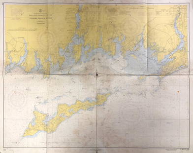
Sold2019Land Ho! Antique Block Island Sound, RI USCGDescription: Ahoy! Antique U.S. Coast Guard nautical chart of Block Island Sound and Approaches. Numbered C. & G. S. 1211; published 1968. Material: paper. Measurement: approximate 36" x 41" (INCHES).See Sold Price
Sold2017Pearson: Antique Chart of Matanzas Bay, Cuba, 1767Map: A New and Correct Draught of the Bay of Matanzas on ye North side of ye Island Cuba done from a Survey by Robt. Perason Cartographer: Pearson Place & Date: London / 1767 Size: 12" x 9" Condition:See Sold Price
Sold2018Antique Chart Of The Antilles Of The CaribbeanFrame: 24.25" x 21 1/8". Image sight: 22 5/8" x 19 5/8". Reproduction of a chart of the Antilles or Charibee or Caribs islands with the virgin isles by LS de la Rochette. London published by William FSee Sold Price
Sold2017Ferrer: Antique Nautical Chart of Nassau River, 18091809 Nautical Chart of Nassau River and Part of Amelia Island and Talbot Island (Florida). Original engraving from José Joaquín de Ferrer y Cafranga's sea atlas, the 'Portulano de los Estados UnidosSee Sold Price
Sold2017Ferrer: Antique Nautical Chart of St. Mary's, 18091809 Nautical Chart of St. Mary's & Cumberland Island, Georgia. Original engraving from José Joaquín de Ferrer y Cafranga's sea atlas, the 'Portulano de los Estados Unidos', published in Madrid in 1See Sold Price
Sold20221895 NAUTICAL CHART - CARIBBEANAntique nautical chart with heavy blue paper backing - Chart #210 Caribee Islands published in London by James Imray & Son 1895 (corrected 1896). 41 x 55 inches, scattered damage/tears as displayed.See Sold Price
Sold2024The Island of Cuba & the Cayman Islands. LOWRY 1860 old antique map plan chartCAPTION PRINTED BELOW PICTURE: 'The Island of Cuba' DATE PRINTED: 1860 IMAGE SIZE: Approx 36.5 x 17.5cm, 14.5 x 6.75 inches (Large); Please note that this is a folding map. TYPE: Antique engraved atlaSee Sold Price
Sold2024View of the island of Otaheite. Tahiti, Polynesia. BANKES 1789 old printCAPTION PRINTED BELOW PICTURE: 'View of the island of Otaheite' DATE PRINTED: 1789 IMAGE SIZE: Approx 14.0 x 19.0cm, 5.5 x 7.5 inches (Medium) TYPE: Antique copperplate print CONDITION: Good; suitableSee Sold Price
Sold2017Mount & Page: Antique Coast Profile of Ireland, 1749Title/Content of Map: '[A description of the sea coast of Ireland]' The following places are shown or referred to on the coastal profile chart: Galloway (Galway) Aran Islands Limerick Date Printed: 17See Sold Price
Sold2021Painted & Dye ChartGroup of 3 pieces. An original oil on board signed Janet Cavelero Navajo Dye Chart & Framed Mola from San Blas IslandSee Sold Price
Sold2017Kitchin: Antique Map of Cape de Verde Islands, 1747Title of the Map: 'A Map or Chart of the Cape de Verde Islands' Cape Verde islands - Cabo Verde - Santo Antão - São Vicente - Santa Luzia - São Nicolau - Sal - Boa Vista - Maio - Santiago - Fogo -See Sold Price
Sold2017Baldwin / Kitchin: Antique Maps Windward Islands, 1782Title/Content of Map: 1782 Baldwin / Kitchin Maps of the Windward Islands -- Island of St. Lucia [on sheet with] Island of St. Vincent [on sheet with] Island of Barbados [on sheet with] Chart of PartSee Sold Price
Sold2021American Coin Silver Spoon Jonathan Otis Rhode IslandThis is an estate found antique American coin silver spoon crafted by Jonathan Otis of Newport, RI (c. 1747-1775) and Middletown, CT (c. 1776-1791). It is monogrammed "NG". 7 3/4" Length. It weighs 1.See Sold Price
Sold2017de la Rochette/Faden: Antique Map Lesser Antilles, 1784Map: A Chart of the Antilles, or: Charibbee, or: Caribs Islands, with the Virgin Isles Cartographer: De la Rochette/Faden Place & Date: London / 1784 Size: 18" x 20 3/8" Condition: b&w (except for wasSee Sold Price
Sold20171775 Plan of the Town & Chart of the Harbour of BostonA Plan of the Town and Chart of the Harbour of Boston Exhibiting a View of the Islands, Castle Forts and Entrances into the Said Harbour, printed at London, 1775 for Gentleman's Magazine. Mild creasinSee Sold Price
Sold2017Bellin/Jefferys: Antique Map of Canada & Islands, 1746Map: A new chart of the coast of New England, Nova Scotia, New France or Canada, with the islands of Newfoundl’d. Cape Breton, St. John’s &c. Publication Date: 1746 Authors: Gentleman’s MagazineSee Sold Price
Sold2017Mount & Page: Antique Coast Profile Ionian Islands 1747How these lands appear at sea' Ionian islands coast profile. The following places are shown or referred to on the coastal profile chart: Corfu Fanu Pachsu (Paxos) Antipaschu (Antipaxos) Marco ZephelonSee Sold Price
1 day LeftJasper52Hawaiian–Emperor seamount chain Midway-Kauai ADMIRALTY chart 1950 (1955) map$140
1 day LeftJasper52Nouvelle Caledonie. Baies de Kuakue et de Uinne'. CHAMBEYRON sea chart 1891 map$100
1 day LeftJasper52Caroline Islands Palau Malakal Ngulu Angaur. ADMIRALTY sea chart 1928 (1956) map$120
1 day LeftJasper52South west Pacific Ocean Melanesia Polynesia ADMIRALTY sea chart 1875 (1968) map$120


![Mount & Page: Antique Coast Profile of Ireland, 1749: Title/Content of Map: '[A description of the sea coast of Ireland]' The following places are shown or referred to on the coastal profile chart: Galloway (Galway) Aran Islands Limerick Date Printed: 17](https://p1.liveauctioneers.com/5584/110608/56777156_1_x.jpg?height=310&quality=70&version=1507840413)


![Baldwin / Kitchin: Antique Maps Windward Islands, 1782: Title/Content of Map: 1782 Baldwin / Kitchin Maps of the Windward Islands -- Island of St. Lucia [on sheet with] Island of St. Vincent [on sheet with] Island of Barbados [on sheet with] Chart of Part](https://p1.liveauctioneers.com/5584/110608/56777137_1_x.jpg?height=310&quality=70&version=1507840413)


