Sold2023U.S. MILITARY WWII FIELD MAPS 1943-1944(5)170300 U.S. MILITARY WWII FIELD MAPS 1943-1944(5) U.S. military WWII field maps 1943-1944 to include one original Europe Road Map Series 1 first edition France with name of soldier Caldwell, two WWIISee Sold Price
Sold2023Japanese occupation of Hong Kong Island 20-25th December 1941 1957 old mapTitle: Japanese occupation of Hong Kong Island 20-25th December 1941 1957 old map Description: Hong Kong Island' by HMSO (1957). Vintage colour military history map, 23.5 x 28.0cm, 9.25 x 11 inches; PSee Sold Price
Sold2021Phelps & Watson's Historical and Military Map of thePublication Date: 1863-06-29 Title: Phelps & Watson's Historical and Military Map of the Border & Southern States. Cartographer: PHELPS/WATSON Publisher: PHELPS & WATSON Height: 25.5 Width: 35.5 Map sSee Sold Price
Sold2018Map of VirginiaTitle: Map of Virginia Medium: Ink on Paper Dimensions: 14" X 19.5' Pre-revolutionary map of Virginia dated 1774. Engraved by the cartographer of the French Navy, possibly for military reasons. Hand dSee Sold Price
Sold20235 Military Watches and Clock Bulova Wrist Watch, Hamilton US Navy Comparing Watch, Waltham a-8Bulova Wristwatch Currently Running Untested For Accuracy , Hamilton Pocket Watch Currently Running Untested For Accuracy , Pilots Clock Currently Running Untested For Accuracy , Waltham a-8 - CurrentSee Sold Price
Sold2020Grp: 5 Maps of Germany Europe and the MediterraneGroup of five 18th century maps. This group includes a hand colored map of Germany by Herman Moll (ca. 1654-1732); one map of the Turkish empire by Tobias Conrad Lotter (1717-1777); one map of the BriSee Sold Price
Sold20205 Military Vehicles, Pre-War and c. 19605 Military Vehicles, Pre-War and c. 1960 1) Siegfried Günthermann, searchlight truck with chains, lithographed tin, spring-driven (working, chain slips), with 2 figures and key, length 7 in., with boSee Sold Price
Sold2020Grp: 5 Maps of Sicily Italy 18th/19th c. JaillotGroup of five 18th and 19th century maps of Sicily. Includes Hubert Jaillot , "La Sicile divisee en ses trois Provinces ou Valees, scavoir Valle Demona, Valle Di Noto, et Valle Di Mazara;" and GuillauSee Sold Price
Sold2022(CIVIL WAR.) P.S. Duval & Son. Military Map of the United States & Territories(CIVIL WAR.) P.S. Duval & Son. Military Map of the United States & Territories Showing the Location of the Military Posts, Arsenals, Navy Yards, & Ports of Entry. Hand-colored lithographed pocket mapSee Sold Price
Sold2023Johnson's New Military Map of the United States. Forts Posts divisions 1861Title: Johnson's New Military Map of the United States. Forts Posts divisions 1861 Description: Johnson's New Military Map of the United States showing the Forts, Military Posts & all the Military DivSee Sold Price
Sold2018SCOTT, Robert Falcon, Captain (1868-1912). The VoyageSCOTT, Robert Falcon, Captain (1868-1912). The Voyage of the Discovery. London: Smith, Elder, 1905. 2 volumes, royal 8vo (237 x 160 mm). Photogravure frontispieces, 12 color-printed plates, 5 maps (2See Sold Price
Sold2020Group Collections of Photography,Letters and MapsGroup collections of Japanese occupied Nanking in World War II. 2 military maps. 2 photography album included 293 pieces photos . One Japanese Bowl.See Sold Price
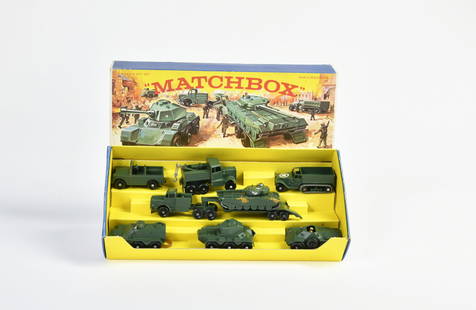
Sold2020Vintage Lesney Matchbox Grand Prix Racetrack Set,Lot includes matchbox series Gift Set G-5 military vehicles set. Contents include 6 Matchbox Series Nos 54,62, 63, 64, 67, 68 and Major Pack M3. military vehicles in very good condition , axels have aSee Sold Price
Sold2022(NEW YORK.) Cadwallader D. Colden. Memoir . . . of the Completion of the New York Canals,(NEW YORK.) Cadwallader D. Colden. Memoir . . . of the Completion of the New York Canals, bound with the 1826 appendix as issued. 5 maps, 39 (of 40) plates, 8 leaves of facsimiles. v, [3], 408, [2] paSee Sold Price
Sold20241905 VOYAGE of DISCOVERY VOLS antique ILLUSTRATED British Antarctic explorationSCOTT, Robert Falcon (1868-1912). The Voyage of the ‘Discovery’. London: John Murray, 1905 2 volumes Photogravure frontispieces, 12 color-printed plates, 5 maps (2 folding in rear pocket), numerouSee Sold Price
Sold2024Carte De La Californie Suivant (early Group of 5 California maps) 1772 [171215]A spectacular set of 5 maps showing California history from 1604 to 1767. Measures 15x12[x=#8221/]. 1) Earliest map (upper right) is based upon a manuscript map by Mathieu Neron Pecci drawn in FlorencSee Sold Price
Sold2024WWI - WWII U.S. ARMY, USMC, USCG Visor Cap Hat Lot of 5NICE LOT OF 5 MILITARY VISOR CAPS FROM WWI - WWII.See Sold Price
Sold2023Matchbox, G-5 Military Vehicles SetMatchbox, G-5 Military Vehicles Set, Great Britain, Druckguss, teilw. angelaufen, Z 2See Sold Price
Sold2018Map of SwitzerlandReserve Reduced! Title: Map of Switzerland Artist: Switzerland Medium: ink on paper Dimensions: 23.5" X 20.5" Map of Switzerland dated around 1750. Engraved by Iohannes Baptiste Hommano in Nuremberg,See Sold Price
Sold2018Map of the United StatesTitle/Content of Map: Map of the United States Date Printed: 1838 Cartographer: ANONYMOUS Material/Medium: Size: 11.6X14.5 Map showing topography, states, lg. MO territory, Northwestern territory (WI,See Sold Price
Sold20221863 Phelps and Watson US Map with Civil War Battles -- Phelps & Watson's Historical and MilitaryTitle: 1863 Phelps and Watson US Map with Civil War Battles -- Phelps & Watson's Historical and Military Map of the Border & Southern States Cartographer: Phelps and Watson Year/Place: 1863, New YorkSee Sold Price
Sold2023WWII U.S MILITARY WAR MAPS OF FRANCE/BELGIUM - (9)171281 WWII U.S MILITARY WAR MAPS OF FRANCE/BELGIUM - (9) WWII U.S. military war maps of France/Belgium to include one sheet 79 Defenses Vierville-Sur-Mer France (12500) war map, two sheet 31/18 S.E.See Sold Price
Sold2023WWII U.S. MILITARY FIELD MAPS 1939-1945 - (4)170301 WWII U.S. MILITARY FIELD MAPS 1939-1945 - (4) WWII U.S. military field maps 1939- 1945 to include one East and West Omaha beach scanned "Bigot" Field maps, one France (12500) Isigny field map,See Sold Price
Sold2022ORTELIUS, ABRAHAM; and PHILILLPE GALLE. Set of 5 miniature maps of the world and continents.ORTELIUS, ABRAHAM; and PHILILLPE GALLE. Set of 5 miniature maps of the world and continents. Engravings with original hand-color. 4x5½ inches each sheet size, Latin text on verso; light finger soSee Sold Price
2 days LeftJasper52North & West Africa. Dahomey. Gold Coast. Military Territory. THE TIMES 1922 map$20
2 days LeftJasper52Northwest Africa. Morocco Sahara Rio do Oro Ain Sefra Gardaia. STANFORD 1904 map$75
2 days LeftHolabird Western Americana CollectionsEarly West Surveys, Photography, 1962 & '75 [182053]$50
5 days LeftWorthington Galleries1705 Map LE COMBAT DE STEENKERKE [Battle of Steenkerque] by Nicolas de Fer$10
397 Lots AwayHermann Historica GmbHAn estate of the airship crew member Leopold Berliner of the Airship Battalion No. 5See Sold Price
15 hrs LeftJasper521660 HISTORY of the WORLD by WALTER RALEIGH antique ILLUSTRATED w/ MAPS English$700
2 days LeftJasper52World War 2 Europe Battle of the Atlantic 1939-43 Axis Expansion limits 1959 map$15


![(NEW YORK.) Cadwallader D. Colden. Memoir . . . of the Completion of the New York Canals,: (NEW YORK.) Cadwallader D. Colden. Memoir . . . of the Completion of the New York Canals, bound with the 1826 appendix as issued. 5 maps, 39 (of 40) plates, 8 leaves of facsimiles. v, [3], 408, [2] pa](https://p1.liveauctioneers.com/199/261738/136414939_1_x.jpg?height=310&quality=70&version=1663269541)

![Carte De La Californie Suivant (early Group of 5 California maps) 1772 [171215]: A spectacular set of 5 maps showing California history from 1604 to 1767. Measures 15x12[x=#8221/]. 1) Earliest map (upper right) is based upon a manuscript map by Mathieu Neron Pecci drawn in Florenc](https://p1.liveauctioneers.com/2699/324080/174413209_1_x.jpg?height=310&quality=70&version=1711485545)


![Maps of Asia & India, c1800's (2) [180164] (1 of 2)](https://p1.liveauctioneers.com/2699/331495/178785787_1_x.jpg?height=282&quality=70&version=1717094933)


![Early West Surveys, Photography, 1962 & '75 [182053] (1 of 9)](https://p1.liveauctioneers.com/2699/331494/178785471_1_x.jpg?height=282&quality=70&version=1717094654)


![1705 Map LE COMBAT DE STEENKERKE [Battle of Steenkerque] by Nicolas de Fer (1 of 1)](https://p1.liveauctioneers.com/6084/330420/178181962_1_x.jpg?height=282&quality=70&version=1716391551)


