Sold2022TWO 16TH TO 18TH CENTURY MAPSA lot of two sixteenth to eighteenth century maps. To include: "A Map of the Parish of St. Giles's" Sheet: 14" x 16.75" "Londinum Feracissimi", engravings on laid paper Sheet: 14.75" x 21"See Sold Price
Sold2017Late 16th Century Maps, Incl. Siege of La Rochelle &Two maps on one sheet. Hand-colored map of Ghent (approx. 8.5 x 11 in.), tipped onto reverse side of page with map of the Siege of La Rochelle (approx. 8.25 x 11 in. plate size). Both maps printed witSee Sold Price
Sold2023Two Ancient Koma Pottery FiguresTerracotta, Comprising a coiled snake and a keening man. 5 1/2" to 11 1/2". 12th-16th Century, Ghana, Africa. Koma figures were originally discovered in the 1980s in what is known as 'Koma Land'. TheSee Sold Price
Sold20241849 Mitchell School ATLAS 24 MAPS America Holy Land France Africa Egypt Asia1849 Mitchell School ATLAS 24 MAPS America Holy Land France Africa Egypt Asia The name Mitchell has long been synonymous with 19th-century maps; in fact, Mitchell maps are often considered the best ofSee Sold Price
Sold2018Late 16th c. hand colored map of IrelandGerhard Mercator (German-Flemish, 1512-1594), late 16th century hand-colored map of Ireland in two parts, titled 'Irlandiae Regnum Miliaria Irlandica Communia,' 17"h x 21"w sight of each sheet, overalSee Sold Price
Sold201916th century Natolie Sive Asie Minor Mercator Map16th Century fine early map of Turkey in Asia, published in Amsterdam by Gerard Mercator. Strapwork cartouche at lower right. Two more cartouches, one shows scales, the other has a Latin inscription.See Sold Price
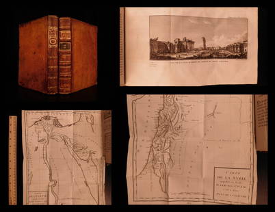
Sold20191799 Voyages in Syria & EGYPT Africa Illustrated MAPS1799 Voyages in Syria & EGYPT Africa Illustrated MAPS Sphinx Pyramids 2v Volney Constantin-François Volney, an 18th-century French philosopher known for his historical works on archaeology and travelSee Sold Price
Sold20201787 1st ed Voyages in Syria & EGYPT Africa Illustrated1787 1st ed Voyages in Syria & EGYPT Africa Illustrated MAPS Sphinx 2v Volney “The best expose of Ottoman Empire at the end of the 18th-century!” (Blackmer) Constantin-François Volney, an 18th-ceSee Sold Price
Sold2020Two Patinated Bronze Relief Plaques.Two Patinated Bronze Relief Plaques. One depicting a centaur and other of 'The Personification of Africa' after the 16th c. German medal (diameter: 7 1/4") Centaur: 6" x 7" x 1 1/4"See Sold Price
Sold20191854 Journey to Central Africa EGYPT Sudan Ethiopia MAP1854 Journey to Central Africa EGYPT Sudan Ethiopia MAP Nile Bayard Taylor Bayard Taylor was a 19th-century travel writer whose abundant notes and reports have been referenced for decades since the miSee Sold Price
Sold2023Box of 35+ Assorted 19th/20th C. Small MapsBox of mostly 19th and early 20th century small maps, approximately 35 pieces including maps of Paris, London, Spain, Caudine Forks, New England, Egypt, Russia, Italy, Europe, Africa, Asia, road maps,See Sold Price
Sold2024Coptic Textile Fragment3rd - 10th Century Coptic textiles, two fragment strips, red background, Egypt, North Africa. Approximate size 7" x 2", 7.5" x 2.5". Matted. PROVENANCE:From the estate of Professor Philip Gould, New YSee Sold Price
Sold20211874 Journey to Central Africa Lakes EGYPT Sudan1874 Journey to Central Africa Lakes EGYPT Sudan Ethiopia MAP Nile Bayard Taylor Bayard Taylor was a 19th-century travel writer whose abundant notes and reports have been referenced for decades sinceSee Sold Price
Sold2022(AFRICA.) Two hand-colored double-page engraved eighteenth-century maps of the continent.(AFRICA.) Two hand-colored double-page engraved eighteenth-century maps of the continent. Nuremberg, 1715-1730s - Homann Heirs. Africa Secundum Legitimas Projectionis Stereographicae. 20¾x24¼See Sold Price
Sold2021Himalaya Region Map Pair16th century AD. A group comprising two printed copper-engraved maps of the Himalayas region; based on work by Claudius Ptolemaeus; the uncoloured version with Latin text to verso, copied from GeograpSee Sold Price
Sold2016Koma (Ghana) Ancient Terracotta Janus FigureWest Africa, North Ghana, Koma, ca. 16th century CE. A wonderfully modeled Janus totemic figure showing two heads back to back with long chins and open mouths; the heads are connected just above the nSee Sold Price
Sold20171833 Nubia & Abyssinia EGYPT Ethiopia Africa Missions1833 Nubia & Abyssinia EGYPT Ethiopia Africa Missions Geography MAP Bishop Michael Russell was a 19th-century historian who was well-versed in a variety of subjects, including Biblical and Holy Land hSee Sold Price
Sold2018Two Disbound Book Leaves Showing the 1571 Siege ofcopperplate engravings, the first by Sebastian Munster with descriptive German text, late 16th century; the second by Alfonsus Lasor Averea with descriptive Latin text, 1713. Both maps presented in siSee Sold Price
Sold2023Two Maps, Africa by Eustache Herisson, 1809, World Hemispheres 1832 Reprint after A.H Brue, GermanDescription: An antique Africa map, in French and dated 1809 by Eustache Herisson, and a reprit of an early 19th century map of World Hemispheres by Adrien-Hubert Brue. Type: MapMaterials: PaperMarkinSee Sold Price
Sold2023Early German Dividing Caliper, 16th CenturyEarly German Dividing Caliper, 16th Century Compass with 2 points, wrought iron, length 11 in. - Used to mark out locations or on nautical chart to measure a distance between two points on a map. Fr&#See Sold Price
Sold2024Coptic Textile Fragment3rd - 10th Century Coptic textile, large fragment, with two inset panel forms comprising circular and octagonal motifs in beige, brown and white, Egypt, North Africa. Approximate size 11" x 8.5". MattSee Sold Price
Sold20231895 AFRICA Morocco EGYPT Sudan Sierra Leonne Sahara Illustrated MAPS 2v SET1895 AFRICA Morocco EGYPT Sudan Sierra Leonne Sahara Illustrated MAPS 2v SET Augustus Keane was a 19th-century historian and author whose studies in ethnology resonate with even modern day ethnologistSee Sold Price
Sold2021Two 16th C. Woodblocks - Copper Smelting FurnacesEuropean, likely Switzerland, ca. 16th to 17th century. A pair of woodcut engravings, possibly from "De re metallica" (Latin for "On the Nature of Metals/Minerals") by Georgius Agricola (published inSee Sold Price
Sold2018Two 16th C Handcolored Engravings Religious WorkTwo hand colored woodcuts from a late 16th century religious work. The woodcuts measure 5 x 3.75" each. Very Good, light traces of mounting tape at margin. Leaves overall measure 8 x 12.75" each. PleaSee Sold Price
1 day LeftTrillium Antique Prints & Rare BooksBraun & Hogenberg, pub. 1575 - View of Cairo, Egypt$100
5 days LeftJasper521816 VOYAGE TO ABYSSINIA by HENRY SALT w/ MAP antique 1st AMERICAN EDITION rare$400
May 14Plakas AuctionsTWO FATIMID TIRAZ (TEXTILE) FRAGMENTS INSCRIBED KUFIC SCRIPT, 10TH CENTURY, EGYPT£1,800