Sold2017Cities and Sea-Coasts and IslandsCities and Sea-Coasts and Islands. by Arthur Symons. W. Collins Sons & Co. LTD, 1918. signed inside front cover VG. Provenance: Estate of Russell Johanson, Ravenna Rare Books, Seattle, Washington. WeSee Sold Price
Sold20201801 General Account Rivers of Great Britain SIGNEDA General Account of All The Rivers of Note in Great Britain; with their Several Courses, Their Peculiar Characters, the Counties through which they Flow, and the Entire Sea Coast of Our Island.., bySee Sold Price
Sold2017Mount & Page: Antique Coast Profile Ionian Islands 1747How these lands appear at sea' Ionian islands coast profile. The following places are shown or referred to on the coastal profile chart: Corfu Fanu Pachsu (Paxos) Antipaschu (Antipaxos) Marco ZephelonSee Sold Price
Sold2024JUNE L. WEBB NEWPORT CITY BY THE SEA POSTERFramed Vintage 1979 June L. Webb City by the Sea Newport Rhode Island Poster. Signed in pencil by the artist. Framed. In frame 18.25"x24.5"x1". Weight 6 lbs.See Sold Price
Sold20214 etchings, by Mark Whitcombe, various subjects,4 etchings, by Mark Whitcombe, various subjects, includes "Music at Night" 5" by 6.5"; "Brice Kirk's Pile Driving Barge, City Islands N.E. coast" 4" by 7.75"; "Alley", 11.75" by 8 5/8" & "Thank you EdSee Sold Price
Sold2020Nautical Map / Sea Chart, #1211 MarthaDescription: Nautical Map / Sea Chart, United States East Coast, Rhode Island - Connecticut - New York, Block Island Sound and Approaces9th edition, dec 23/63 stamped CORRECTED ONLY FOR AIDS & HAZARDSSee Sold Price
Sold2017Mount & Page: Antique Coast Profile of Ireland, 1749Title/Content of Map: '[A description of the sea coast of Ireland]' The following places are shown or referred to on the coastal profile chart: Galloway (Galway) Aran Islands Limerick Date Printed: 17See Sold Price
Sold2017Pair of Seascape Paintings, artist signedTwo framed paintings of sea scenes. Signed by artist possibly Apryphe. Height: 18 7/8" Width: 14 1/2" Image: Height: 14" Width:11"(sea, boats, trompe l'oeil, bay, island, coast, Mediterranean)STERLINGSee Sold Price
Sold2021Nautical Map / Sea Chart, #362 Block Island Sound andDescription: Nautical Map / Sea Chart, United States East Coast, New York, Long Island, Block Island Sound and Gardiner's Bay, 6th edition, Feb 10/69; Shipping: $20; different rate to California, AlasSee Sold Price
Sold2019Jean Baptiste D’Anville (1699-1782), "Europe, DividedJean Baptiste D’Anville (1699-1782), "Europe, Divided into its Empires, Kingdoms, States, Republics"1795; and "Western and Eastern Parts of the Meditreanean Sea, with coasts of Spain, France, ISee Sold Price
Sold2019Hydrographic Office U. S. Navy, "France- North Coast-Hydrographic Office U. S. Navy, "France- North Coast- Channel Islands and Adjacent Coasts," 1936, H. -46 in., W. - 35 in.See Sold Price
Sold2020Nautical Map / Sea Chart, #1212 Eastern Long IslandDescription: Nautical Map / Sea Chart, United States East Coast, Connecticut - New York, Long Island Sound, Eastern Part, 12th edition feb 10 / 69 ; all measurements are approximate; Folded; ShippingSee Sold Price
Sold2019Three Maps from the Hydrographic Office U. S. Navy, theThree Maps from the Hydrographic Office U. S. Navy, the first "North Pacific Ocean, Caroline Islands, North Coast of Ponape Island, Ponape Harbor to Talak Passage," 1944, H. -30 in., W. -42 in.; withSee Sold Price
Sold2024A New and Exact Map of the Coast, Countries and Islands within the, limits of the South Sea CompanyA New and Exact Map of the Coast, Countries and Islands within the limits of the South Sea Company by Moll (London, 1711) "A New and Exact Map of the Coast, Countries and Islands within the limits ofSee Sold Price
Sold2023Print, Herman MollHerman Moll (British, 1654-1732), "A New and Exact Map of the Coast, Countries and Islands within ye Limits of ye South Sea Company, from ye River Aranoca to Tierra del Fuego, and from thence throughSee Sold Price
Sold2022Two rare books. The first titled "Narrative Of A Voyage In His Majesty's Late Ship Alceste, To TheTwo rare books. The first titled "Narrative Of A Voyage In His Majesty's Late Ship Alceste, To The Yellow Sea, Along The Coast of Corea and Through It's Numerous Hitherto Undiscovered Islands, To TheSee Sold Price
Sold2020John M'Leod bookM'Leod, Surgeon John- ''Narrative of a Voyage in His Majesty's late ship Alceste to the Yellow Sea, along the Coast of Corea and Through its Numerous Hitherto Undiscovered Islands, to the Island of LeSee Sold Price
Sold2019West-Indies – Bahama’s, Turks Island, British AdmiraltyDetailed, unused and early chart of the coast of Turks Island. The first surveys are from 1830 by Captain R. Owen. With tidal information. Authentic, very detailed sea chart, no modern copy. On thickSee Sold Price
Sold2024Rhodes Ar Tetradrachm 408 BC CoinRhodes, an island in the eastern Aegean Sea, was an important city-state in ancient Greece known for its maritime power and cultural achievements. The island issued its own coinage, including the AR TSee Sold Price
Sold2019United States – Nantucket Island British AdmiraltyTitle: United States – Nantucket Island British Admiralty Chart 2489, published 1896 Date: 1896 Cartographer: British Admiralty Size: 28x41 in Hardly used sea chart of the the treacherous coast ofSee Sold Price
Sold2024USC&GS Map, Martha's Vineyard to Block Island, MassachusettsA color map depicting the land and sea area of Martha's Vineyard to Block Island. Publishing stamp by "The U.S Coast and Geodetic Survey" located on bottom. Issued: 1941 Dimensions: 50"L x 36"W ManufaSee Sold Price
Sold202419th c. Sea Turtle Tortoise Shell Taxidermy19th Century Sea Turtle Tortoise Shell Taxidermy Approx: 4 1/4"H x 17 3/4"L x 13 1/2"W In Overall Good Condition Please Look at Photos Closely Out of a New York City EstateSee Sold Price
Sold2024Antique 19th c. Sea Turtle Tortoise Shell Taxidermy19th / 20th Century Sea Turtle Turtoise Shell Taxidermy Approx: 4 3/4"H x 18 1/4"L x 11 1/4"W In Overall Good Condition Please Look at Photos Closely Out of a New York City EstateSee Sold Price
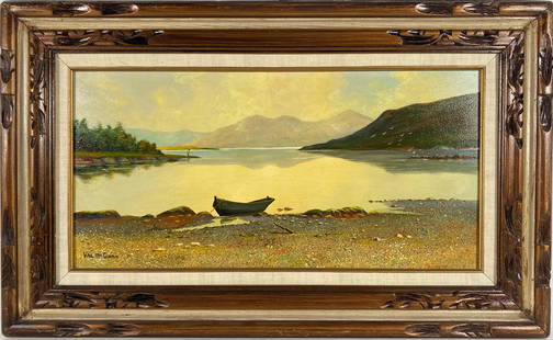
Sold2021Val McGann (1928-2016 Maine, Florida, Ireland)Oil on Board Kylemore Lough Connemara by Val McGann. Depicting rowboat by sea shore. Dimensions 19.5in H x 31.4in L. Painting is in overall great condition. Out of a new york city estate.See Sold Price
4 days LeftJasper52West India Islands & Caribbean Sea Sheet 2 ADMIRALTY sea chart 1913 (1949) map$120
4 days LeftJasper52Amér. Sep. Curacao #74. Aruba Bonaire Puerto Rico Beata. VANDERMAELEN 1827 map$140
4 days LeftJasper52Grand Bahama & Great Abaco Islands. Bahamas. ADMIRALTY sea chart 1886 (1968) map$140
5 days LeftCapsule AuctionsHiroshi Yoshida - Three Little Islands (from series The Inland Sea, second series)$100(1 bid)
4 days LeftJasper52Anguilla St. Martin/Maarten Barts. Caribbean. US Navy sea chart 1899 (1917) map$280
5 days LeftA.H. Wilkens Auctions & AppraisalsJEFFERYS. AN EXACT CHART OF THE RIVER ST. LAURENCECA$200(1 bid)
4 days LeftJasper52Bahamas harbours Pelican Abaco Berry I Jumentos ADMIRALTY chart 1899 (1920) map$140
3 days LeftMynt AuctionsAegean Weave Gold by Wallace Sterling Silver Flatware Set 6 Service 24 Pieces$10


![Mount & Page: Antique Coast Profile of Ireland, 1749: Title/Content of Map: '[A description of the sea coast of Ireland]' The following places are shown or referred to on the coastal profile chart: Galloway (Galway) Aran Islands Limerick Date Printed: 17](https://p1.liveauctioneers.com/5584/110608/56777156_1_x.jpg?height=310&quality=70&version=1507840413)