Sold2017EARLY NEW YORK STATE ACTUAL SURVEY MAPEARLY NEW YORK STATE ACTUAL SURVEY MAP FOR COUNTIES ALONG SUSQUAHANNAH RIVER, INCL. CLINTON, CHENANGO, GREEN, ETC. 18TH C. 15 1/2" X 21"See Sold Price
Sold2024Early 1860 school map of New York State, From New & Original surveys Under the direction of J.H.Early 1860 school map of New York State, From New & Original surveys Under the direction of J.H. French C.E.Syracuse 1860, loss on sides, foldmarks, paper on linen, map is 68.5" by 72"See Sold Price
Sold2018Map of the United States Solomon Schoyer 1826 EngravingWonderful Early 19th Century Antique Map of the United States - By Solomon Schoyer. Map of the United States Drawn from the Most Approved Surveys. New York: Solomon Schoyer, 1826. An Engraved foldingSee Sold Price
Sold2022Scarce early Cram RR map of New YorkExceedingly scarce New York state map from the last Cram atlas to feature hand colored maps. “New Railroad and County Map of New York” from the very scarce 1882 Cram’s Unrivaled FamSee Sold Price
Sold2018Map, "Delaware County, New York, Philadelphia, 1856Map, "Delaware County, New York, From Actual Survey by Jay Could, Published by Collins G. Keeney, Philadelphia, 1856, various county scenes on top margin, map is damages with some loss at top, size isSee Sold Price
Sold2023Two early maps in America and North America.Two early hand colored maps of New York State & North America including: The first, New Caldonia when it was still a colony of Scotland, dated 1699 - published by M. Moll - very good condition; and thSee Sold Price
Sold201713 1859 U.S. Coastal Survey MapsDESCRIPTION: Collection of thirteen 1859 United States coastal survey maps from a trigonometrical survey. Includes: St. Mary's River, Maryland; New York Bay and Hudson River; Port Royal Entrance of SoSee Sold Price
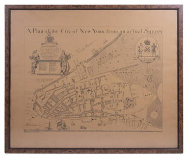
Sold2023REPLICA OF LAING'S MAP OF MANHATTAN"A Plan of the City of New York from an actual Survey" for His Excellency John Montgomerie, by William Bradford, printed on tan paper, in a faux tortoiseshell frame, under glass, 23" x 26", good condiSee Sold Price
Sold202019th C. Plan of the city of New York from an actual19th C. - A plan of the city of New York from an actual survey Known as the Bradford Plan. By James Lyne and Publisher:New-York : Pubed. by G. Hayward. Notes: Facsimile of an original map [New York :See Sold Price
Sold2016Official Maps of New YorkNumerous color maps of all areas of New York State. 128 pages. Publisher National Survey Company Dated: Circa 1925 Demensions: 8vo Provenance: Property of a New York City Gentleman ConditionSee Sold Price
Sold2023Civil War Era Itemsitems to include: Epaulette, Solider tin type, brass bleeder in case, pewter snuff box, powder horn with dog, early 1800's fork in leather case, Burr's map of New York State 1835 in poor condition, 18See Sold Price
Sold2018The State of New York, Compiled from the most AuthenticTitle/Content of Map: The State of New York, Compiled from the most Authentic Information. 1796. Cartographer: D. Martin Height (inches): 15.25 Width (inches): 18Year: 1796 Martin Sculpt.Curious earlySee Sold Price
Sold202118TH C. (1755) MAP OF N.Y. , PENSYLVANIA & NEW ENGLANDFRAMED 18TH C. (DATED 1755) 2 PART MAP "A MAP OF THE PROVINCE OF NEW YORK, WITH PART OF PENSILVANIA AND NEW ENGLAND / FROM AN ACTUAL SURVEY BY CAPTAIN MONTRESOR, ENGINEER 1755" - FRAME 59 1/4" X 39",See Sold Price
Sold2017Two New York MapsOne a map of The Highland and the Highlands of Hudson County, from actual survey's by James P Kirby PC. The second a property map. Together with a land survey of lands owned by The Deer Hill Company LSee Sold Price
Sold2022IMPORTANT REVOLUTIONARY WAR-ERA MAP OF NEW YORK AND NEW JERSEY 1776 29” x 23” sight.IMPORTANT REVOLUTIONARY WAR-ERA MAP OF NEW YORK AND NEW JERSEY1776“A Map of the Province of New-York, Reduc'd from the large Drawing of that Province, Compiled from Actual Surveys by Order of HiSee Sold Price
Sold2017LOT (3) EARLY POCKET BOOK MAPS C.1830'sLOT (3) EARLY POCKET BOOK MAPS INCL. H/C STATE OF NEW YORK BY HUMPHREY PHELPS,1833, 16" X 21", STATE OF NEW JERSEY BY J. LOW, C. 1830, 10 1/2" X 7 1/2", STATE OF PENNSYLVANIA BY A. FINLEY, C. 1830, 9"See Sold Price
Sold2017Map, Orange and Rockland Counties New York 1859From actual Surveys by F.F. French W.F Wood & S.N. Beers, Corey & Bachman Publishers. 6'1"w x 5'7"lSee Sold Price
Sold2021Antique New York State Map 1903 Color Roll Up RR Map1903 Scarborough's New Railroad, Post Office, Township and County Map of New York. Color map, compiled from the latest government and state surveys and original sources of the era. Insets: Map of NewSee Sold Price
Sold2020Early United States Roll-Up MapEarly United States roll-up map. Published by J. H. Colton / New York / 1853. 44 1/2" x 36".See Sold Price
Sold2022(NEW YORK.) John Homer French. The State of New York from New and Original Surveys.(NEW YORK.) John Homer French. The State of New York from New and Original Surveys. Large hand-colored engraved wall map of New York with many inset views and detail maps. 4 sheets joined, 68x73 incheSee Sold Price
2023MAP OF MARYLAND AND DELAWARE BY JOHN REID.Engraved map on laid paper, published by John Reid, New York. "The States of Maryland and Delaware, from the Latest Surveys, 1795" with Chesapeake Bay in the middle. Stains, minor creases, glued down.See Sold Price
Sold2023Maps of New York Topography MapsMaps of New York Topography Maps This lot has two vintage maps of New York that show surveys that were done in the late 1800s and early 1900s. These maps are in good condition with a few small tears oSee Sold Price
Sold2023Five Early Boxed Child GamesIncluding Dissected Map of the United States, McLoughlin Bros. Manuf. New York, 15 x 21" when assembled (missing several states and territories) double sides, box is wood with chromolithographed labelSee Sold Price
Sold2019State of New YorkTitle: State of New York Publication Date: 1809 Cartographer: LEWIS, SAMUEL Publisher: MATHEW CAREY Size: 16.1Height - 20.6Width compiled from the best authorities. 1809… Interesting early state mapSee Sold Price
Jun 02Schilb Antiquarian Rare Books1905 Democratic Party 1ed NEW YORK Government Federalists Whigs Jacksons 3v$1
Jun 08Early American History Auctions1834 ALEXANDER MACOMB + THOMAS SIDNEY JESUP Dual-Sided Autograph Letter and Presentation Poem Signed$1,100(1 bid)
Jun 08Early American History Auctions1776 Map, PARTIE ORIENTALE DU CANADA, AVEC LA NOUVELLE ANGLETERRE, L'ACADIE... by P. Santini, Framed$950
1 day LeftRapid Estate Liquidators and Auction GalleryEarly 20th Century Era Grand Central Zone to the Battery, New York Frame Photogravure$120
Jun 08Early American History Auctions1836 Hand-Colored Map, Country Twenty Five Miles Round The City Of New-York Published by D.S. Stone$260
Jun 06Freeman's | HindmanCLEMENS, Samuel Langhorne ("Mark Twain") (1835-1910). Adventures of Huckleberry Finn. New York:$2,000
Jun 01Ripley AuctionsCarol Hepper, New York, South Dakota (1953-2021), Portland Plumbing #1, 1994, copper and steel, 9"H$500
Jun 06Freeman's | HindmanTHOREAU, Henry David (1817-1862). [The Season Books]. Early Spring in Massachusetts. 1881. --$400
2 days LeftForum AuctionsIndia.- Laurie & Whittle (publishers) A New Map of the Jaghir Lands, on the Coast of Coromandel, The£75
2 days LeftWinbids AuctionsLa Triomphe Geometric Cocktail Ring In 18Kt Gold With Diamonds Coral Onyx$1,700
10 hrs LeftJasper52c1863 Civil War era Virginia with Washington D.C. and View of The Capital. By C. Magnus$220


![[STEREOS] EARLY NY STATE. LOT OF 7 SOLD TOGETHER (1 of 2)](https://p1.liveauctioneers.com/8124/329803/177770658_1_x.jpg?height=282&quality=70&version=1715634941)


![THOREAU, Henry David (1817-1862). [The Season Books]. Early Spring in Massachusetts. 1881. -- (1 of 1)](https://p1.liveauctioneers.com/197/329405/177652637_1_x.jpg?height=282&quality=70&version=1715364568)


