Sold2023Civil War era 1863 map of Mexico & Caribbean nationsLovely and vintage double-page map showing all of Mexico, Central America, Texas, Indian Territory and states of the Deep South during the middle of the American Civil War. Map has an 1860 copyright bSee Sold Price
Sold202319th century. A hand-colored American Civil War era map of Virginia, Delaware, Maryland, and West19th century. A hand-colored American Civil War era map of Virginia, Delaware, Maryland, and West Virginia. Published by A.J. Johnson New York USA. Marked as page 47. Overall good condition; some browSee Sold Price
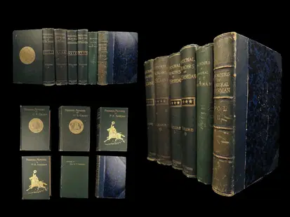
Sold20241885 CIVIL WAR 1ed Famous Memoirs US Grant Sheridan Sherman 6v RARE LOT Maps1885 CIVIL WAR 1ed Famous Memoirs US Grant Sheridan Sherman 6v RARE LOT Maps An impressive collection of the three most iconic memoirs of Union officers of American Civil War – Ulysses S Grant, PhilSee Sold Price
Sold2022Antique Prints including Gettysburg Battle Map. 28Antique Prints including Gettysburg Battle Map. 28 piece grouping of antique engravings and illustration prints. Featuring a unique circular recreation of the American Civil War Battle of Gettysburg,See Sold Price
Sold2021THE WEST POINT ATLAS OF AMERICAN WARS, V. ESPOSITO:THE WEST POINT ATLAS OF AMERICAN WARS, V. ESPOSITO: 1st Edition of 1959, Two Volumes by Frederick Praeger Publisher. Best Collection of Maps of American Wars from the French and Indian to Korean War.See Sold Price
Sold2021Map of the Southern States - American Civil WarTitle: Map of the Southern States, Including Rail Roads, County Towns, State Capitals, County Roads, the Southern Coast from Delaware to Texas, Showing the Harbors, Inlets, Forts and Position of BlocSee Sold Price
Sold2017Cram: Antique Map Plan of San Francisco, 1891Map: San Francisco Date: 1891 From Cram's "Unrivaled Family Atlas of the World Indexed" Size: 11 x 14.5 inches George F. Cram (1842-1928) served in the U.S. Army during the American Civil War. After tSee Sold Price
Sold2017Cram: Antique Map of Indian Territory, 1891Map: Indian Territory Date: 1891 From Cram's "Unrivaled Family Atlas of the World Indexed" Size: 14.5 x 11 inches George F. Cram (1842-1928) served in the U.S. Army during the American Civil War. AfteSee Sold Price
Sold2022ANTIQUE AMERICAN CIVIL WAR ENGRAVING COLLECTIONAn antique lithograph Surrender of General Lee, At Appomattox C.H.VA April 9th 1865 by Currier and Ives (American, 1834-1907). A cover page with an engraved illustration from the Frank Leslie's IllustSee Sold Price
Sold2017Cram: Antique Map of California, 1891Map: California Date: 1891 From Cram's "Unrivaled Family Atlas of the World Indexed" Size: 14 x 22 inches George F. Cram (1842-1928) served in the U.S. Army during the American Civil War. After the waSee Sold Price
Sold2022ANTIQUE AMERICAN CIVIL WAR ENGRAVING COLLECTIONAn antique engraved print titled The Old Clothes Market, A Scene in Richmond, VA. Issued 1870, Every Saturday: An Illustrated Journal of Choice Reading. It is an original pictorial sheet extracted froSee Sold Price
Sold2016George Cram: Nova Scotia Map Plate 2, 1891Map: Nova Scotia Plate 2 Maker: George Cram Date: 1891 Size: 21.75 x 13.5 inches For "The Home Knowledge Atlas" George F. Cram (1842-1928) served in the U.S. Army during the American Civil War. AfterSee Sold Price
Sold2016George Cram: Map of Eastern Part of Quebec, 1891Map: Eastern Part of Quebec Maker: George Cram Date: 1891 Size: 13.5 x 21.75 inches For "The Home Knowledge Atlas" George F. Cram (1842-1928) served in the U.S. Army during the American Civil War. AftSee Sold Price
Sold2016Geroge Cram: Map of Western Part of Quebec, 1891Map: Western Part of Quebec Maker: George Cram Date: 1891 Size: 13.5 x 21.75 inches For "The Home Knowledge Atlas" George F. Cram (1842-1928) served in the U.S. Army during the American Civil War. AftSee Sold Price
Sold2017Group of Harpers Weekly Civil War Era Pages and PrintsFeaturing Maps, People, and Other MiscellaneousSee Sold Price
Sold2022Civil War Military map - scarce territorial bordersThe Johnson and Ward atlas company produced two memorable, double-page Civil War maps of the United States. This is the more desirable issue, showing the state and territory borders instead of the MilSee Sold Price
Sold2018(2) CIVIL WAR ERA CDV ALBUMS with PHOTOGRAPHS(1) Twelve page album with African American subjects (tin type and cdv) and Civil War officer and artwork. (1) Thirty page album of tin types and cdvs including cdvs of prints.See Sold Price
Sold2023Civil War era map of North America from S. A. Mitchell Jr.Wonderful map of the North American continent with 1860 date but published in the 1863 Mitchell New General Atlas. Shows the United States at the height of the Civil War. Depicts the North American coSee Sold Price
Sold2022County Map of California, Mitchell 1860Lovely hand-colored map of California during the Civil War era. One of the earliest maps of California to appear in an American Atlas. Shows California divided into counties, showing all major towns aSee Sold Price
Sold2022Great specimen of antique map of N. and S. CarolinaExcellent map of these two Atlantic states in the years following the Civil War. From an 1874 edition of S. Augustus Mitchell’s New General Atlas, one of the better American atlas publishers ofSee Sold Price
Sold2022Title page of Schonberg’s 1864 atlas, 1864 scarce publication by SchonbergTitle: Title page of Schonberg’s 1864 atlas, 1864 scarce publication by Schonberg Date/Period: 1864 Materials: Hand colored steel engraved Size: 14 x 12'' 1864 uncommon civil war era map by SchoSee Sold Price
Sold2020Civil War MapAuthor: Steele Title: Civil War Map Medium: Ink on paper Dimensions: 18"X13" Map dated 1942 capturing the siege of Petersburg. Part of the Atlas that accompanied Steele's American Campaigns. This AtlaSee Sold Price
Sold2021Two 19th Century American MapsA map that describes the Atlanta Campaign from the Atlas of the official records of the Union and the Confederate Armies, published by Julius Bein and Co. And an Dutch map that depicts Dakota, Iowa, NSee Sold Price
Sold2021American Civil War CollectionConte #57101 Confederates Charging, Britains Snake Rail Fence #17149, and Frontline Confederate Firing over horse (unboxed). 6 pieces. Mint condition. Boxes excellent.See Sold Price
4 days LeftFleischer's AuctionsLincoln's Funeral Cortège Book by Custodian of Lincoln's Tomb$150(2 bids)
5 days LeftUniversity ArchivesAbraham Lincoln Photo After Mathew Brady, Meserve Printed & Collected$100
5 days LeftUniversity ArchivesLincoln Brady Photo Study for Carpenter's "First Reading of the Emancipation Proclamation," Meserve $100(1 bid)
Jun 02Schilb Antiquarian Rare Books1866 Women of the Civil War 1ed Americana Gettysburg Military Robert E Lee Moore$100(2 bids)
4 days LeftFleischer's Auctions[LINCOLN] 1864 California National Union Ticket "Rally Round the Boys!"$100(1 bid)


![[RE LEE] Signed Photograph & Letter To Namesake (1 of 3)](https://p1.liveauctioneers.com/7226/325455/175169169_1_x.jpg?height=282&quality=70&version=1712370394)


![[LINCOLN] 1876 Radical Republican Hayes Ballot (1 of 1)](https://p1.liveauctioneers.com/7226/322253/173251603_1_x.jpg?height=282&quality=70&version=1710004847)


![[LINCOLN] Family Friend's Mournful Assassination Reaction (1 of 1)](https://p1.liveauctioneers.com/7226/322253/173251617_1_x.jpg?height=282&quality=70&version=1710004847)


![[BUTTRE, J. C. (1821-1893), engraver]. Abraham Lincoln. [Ne... (1 of 1)](https://p1.liveauctioneers.com/928/328184/176813626_1_x.jpg?height=282&quality=70&version=1714496988)


![[LINCOLN] 1864 California National Union Ticket "Rally Round the Boys!" (1 of 1)](https://p1.liveauctioneers.com/7226/322253/173251604_1_x.jpg?height=282&quality=70&version=1710004847)