Sold2020Bartholomew, John 1922 Lot of 8 Maps of CanadaIncl Political, British Columbia, Alberta/Saskatchewan, Manitoba/North West Ontario, Ontario/Quebec, Maritime Provinces/Newfoundland, Western Canada, and North Eastern Canada. Large Lithograph Maps PuSee Sold Price
Sold2019JAMES BARNSLEY (1861-1929, Canada) ImpressionistSeascape. Harbor scene. Possibly France or Haiti, where the artists spent time. Oil on canvas laid on board. 20 x 14 in. Born in West Flamboro, Ontario in 1861. Died in Verdun, Quebec in 1929. BarnsleSee Sold Price
Sold2019Meyer: Upper Canada (Ontario) / Lower Canada (Quebec)Map Title: Ober (Upper) Canada 1849 / Unter (Lower) Canada 1849 Cartographer: Bibliographischen Instituts. Place/Date: Hildburghausen / 1849/1857 Size: 14 5/8" x 11 3/4" Condition: original outline coSee Sold Price
Sold20191855 Colton Map of Ontario -- Canada West or UpperTitle/Content of Map: 1855 Colton Map of Ontario -- Canada West or Upper Canada Date: 1855, New York Cartographer: J Colton Size: 11.8 X 14.7 in. This is a very nice map of today's Ontario. Plenty ofSee Sold Price
Sold2019Albert Henry Robinson(1881-1956)Canada ArtistAlbert Henry Robinson (1881 - 1956) Albert Henry Robinson was active/lived in Quebec, Ontario / Canada. Albert Robinson is known for bucolic landscape and figure painting. Signed Lower Right Oil on CaSee Sold Price
Sold2019Albert Robinson 1881-1956 Canadian Listed Artist OilAlbert Henry Robinson (1881 - 1956) Albert Henry Robinson was active/lived in Quebec, Ontario / Canada. Albert Robinson is known for bucolic landscape and figure painting. Oil on Board Painting Size:See Sold Price
Sold2024Graham Noble Norwell (1901 - 1967) WPA LandscapeGraham Noble Norwell (Ontario, Quebec / Canada, 1901 - 1967) WPA style regionalist landscape. Colored pencil on cardboard. Signed lower left. Size: 6 x 9 in. Unframed.See Sold Price
Sold2024Graham Noble Norwell (1901 - 1967) WPA LandscapeGraham Noble Norwell (Ontario, Quebec / Canada, 1901 - 1967) WPA style regionalist landscape. Colored pencil on cardboard. Signed lower right. Size: 10 x 12.5 in. Unframed.See Sold Price
Sold2019Benjamin Chee Chee (1944-1977) Dancing GooseFramed lithograph in colors by Benjamin Chee Chee (Ojibwa, Ontario / Quebec, Canada 1944-1977) Titled Dancing Goose. Artist signed and dated 75 (1975). Sheet site measurement 8.5" x 5.5". Framed and mSee Sold Price
Sold2020WEST CANADA'. Southern Ontario. Shows'Indian territory'TITLE/CONTENT OF MAP: 'West Canada' The map shows the eastern part of modern Ontario, divided into districts/counties. Part of the map is shown as "Indian territory", with "Indian traders" marked. VigSee Sold Price
Sold2019WEST CANADA. Southern Ontario. Shows 'Indian territory'TITLE/CONTENT OF MAP: 'West Canada' The map shows the eastern part of modern Ontario, divided into districts/counties. Part of the map is shown as "Indian territory", with "Indian traders" marked. VigSee Sold Price
Sold2019WEST CANADA'. Southern Ontario. Shows'Indian territory'TITLE/CONTENT OF MAP: 'West Canada' The map shows the eastern part of modern Ontario, divided into districts/counties. Part of the map is shown as "Indian territory", with "Indian traders" marked. VigSee Sold Price
Sold2019Stanford Map of North AmericaSTANFORD, Edward (1827-1904). North America (Sheet II) The dominion of Canada, parts of Quebec and New Brunswick... Lithograph with original hand color from the Society for the Diffusion of Useful KnoSee Sold Price
Sold2016Map of New Brunswick & Quebec, Dominion of Canada, 1868Original engraving from Johnson's Atlas of the World, 1868. Map details cities, towns and territories. Dimensions: 18" x 26". No Reserve This item ships from Ocean View, DE.See Sold Price
Sold2019Canada West or Upper Canada. Lower Ontario. AntiqueTITLE OF MAP (NOT PRINTED ON THE PAGE):'Canada West or Upper Canada' DATE PRINTED: 1863 IMAGE SIZE: Approx 34.5 x 42.0cm, 13.5 x 16.5 inches (Large) TYPE: Antique engraved hand coloured atlas map CONDSee Sold Price
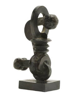
Sold2019Sorel Etrog (1933-2014 Canadian/Romanian)Corinth, 1969 Patinated bronze Edition 3/10, signed to base: Etrog 6" H x 2.25" H x 2" D Provenance: Dominion Gallery, Montreal, Quebec, Canada. Estate of Mrs. Donald M. Jones, Pasadena, CA. Notes: ASee Sold Price
Sold2020AN ANTIQUE MAP, "New Railroad Map of the United States,AN ANTIQUE MAP, "New Railroad Map of the United States, the Dominion of Canada, Mexico and the West Indies," CHICAGO, CIRCA 1875, hand-colored lithograph on paper, publishing, engraving, and printingSee Sold Price
Sold2023Morton & Co. Brantford, C.W., 4 Gallon Stoneware JugCanadian. Brantford, Ontario. Salt-glazed stoneware. A fine example of a Morton & Company 4-gallon stoneware jug from Brantford, Ontario; "C.W." denoting Canada West. Justus Morton founded Brantford pSee Sold Price
Sold2019Nicely Framed 19th Century Map Of Montreal, CanadaJohnson's. Quebec, The Dominion Of Canada Map 1867. Nicely framed under glass. 23 3/4 x 18 in. (sight), 30 x 24 in. (framed).See Sold Price
2020Arthur Lismer (1885 - 1969) Ontario/Canada Artist OilArthur Lismer (1885 - 1969) Arthur Lismer was active/lived in Ontario, Nova Scotia, Quebec / Canada, England. Arthur Lismer is known for modernist landscape painting, teaching. Medium: Oil on canvas bSee Sold Price
Sold2024[ONTARIO / QUEBEC] LOT OF 33 PIECES SOLD TOGETHERONTARIO / QUEBEC. A lot of approximately 33 pieces sold together. Mostly early 20th century. Condition and sizes vary. Including: souvenir viewbooks and albums (Niagara, St. Catherines, Twin Cities, LSee Sold Price
Sold20231-Gallon Picton Canada West Stoneware JugCanadian. Picton, Ontario. Salt-glazed stoneware. A one-gallon jug with a single loop handle and stylized swirl decoration in dark cobalt blue. Attributed to G.I. Lazier of the Picton pottery (1864-18See Sold Price
Sold2017John Tallis: Map of West Canada, 1865Map: West Canada Maker: John Tallis & Co. Date: 1865 Size: Quarto - 8.5 inches high x 11.6 inches wide Scarce third state. Details counties, topography, Lake Ontario, Lake Erie, Lake Huron, etc. VigneSee Sold Price
Sold2018Tallis/Rapkin: Antique Map of West Canada, 1849TITLE/CONTENT OF MAP: 'West Canada' The map shows the eastern part of modern Ontario, divided into districts/counties. Part of the map is shown as "Indian territory", with "Indian traders" marked. VigSee Sold Price
6 days LeftMynt Auctions1942 Hand Drawn Canada Cover Toronto Ontario to West Perth Australia Agriculture$280
2 days LeftFreeman's | HindmanAlfred Joseph Casson (Canadian, 1895-1984) Farm on Kilmer Road (Quebec)$17,000(2 bids)
2 days LeftRail & Road AuctionsSeven Canadian Pacific Railway Dining Car Menus - Banff Springs Hotel, The Dominion, Asbestos Mining$30
Jun 15Bazaar of PersiaCanada Revenue Collection - Ontario - Law - 1929/40 Stamps - van Dam OL84 - $1-5 - F/VF Used$30
Jun 02Schilb Antiquarian Rare Books1900 Views of Montreal CANADA Quebec Victoria Square Notre Dame Mt Royal Park 2v$1(1 bid)


![[ONTARIO / QUEBEC] LOT OF 33 PIECES SOLD TOGETHER: ONTARIO / QUEBEC. A lot of approximately 33 pieces sold together. Mostly early 20th century. Condition and sizes vary. Including: souvenir viewbooks and albums (Niagara, St. Catherines, Twin Cities, L](https://p1.liveauctioneers.com/8124/322212/173234984_1_x.jpg?height=310&quality=70&version=1709937662)


