Sold2016An Accurate Map of the Netherlands. Europa. 1773.Copper engraving, hand colored print titled, “A New and Accurate Map of the Netherlands from the Sieur Roberts Atlas with Improvements“. Drawn by G.Rollos. Engraved by J. Gibson.Published in FennSee Sold Price
Sold2024[ARCTIC]. BOWEN, Emanuel. A New & Accurate Map of the North...[ARCTIC]. BOWEN, Emanuel. A New & Accurate Map of the North Pole. London, [ca. 1746]. Copper-plate map, hand-colored, of the regions north of 50 degrees. The western side of North America is marked PaSee Sold Price
Sold2022MAP OF NORTH POLEBowen, Emanuel. A NEW & ACCURATE MAP OF THE NORTH POLE (ca. 1745). Copper engraving. Hand colored. Framed and mounted. Highly detailed map of North Pole to 50th parallel including surrounding lands anSee Sold Price
Sold2016MAP OF JAPAN'A New and Accurate Map of the Empire of Japan', by Emanuel Bowen, hand-colored engraving, London, c. 1747, Lutz OAG 92, framed, 18-1/2 x 21-1/2 in. (overall)See Sold Price
Sold2021"Terra FIrma and Caribbe Islands", Emanuel Bowen"A New and Accurate Map of the Terra Firma and the Caribbe Islands", an 18th century map by Emanuel Bowen (1693-1767). An engraved and hand colored map in two pages with central fold crease, framed. 1See Sold Price
Sold2022MAP OF WESTERN HEMISPHERE (AMERICAS)Bowen, Emanuel. A NEW AND ACCURATE MAP OF AMERICA (London, ca. 1745). Double page engraving. Hand colored. Framed and mounted. Highly detailed map of Western Hemisphere showing the Americas, Pacific iSee Sold Price
Sold2017Map: Hudson's Bay in North America, 1782, J. BewA framed map: New and Accurate Chart of Hudson's Bay in North America. Published, London Nov. 1782, By J. Bew, Pater Noster Row. Hand colored map, sight measurement 7.25" x 9.25". Framed and matted unSee Sold Price
Sold2024Aitchison, Alexander 1799 Hand Col Map. North America"An Accurate Map of North America with the New Discoveries 1796" Hand Colored Copper Engraved Map Published 1798-99, London for "The Modern Gazetteer; Being a compendious Geographical Dictionary?" bySee Sold Price
Sold2022Thomas Bowen,1778, Map, Western Atlantic Ocean"Thomas Bowen, London 1778, A New & Accurate Chart of the Western or Atlantic Ocean Drawn from Surveys and most approved Maps & Charts" by Thomas Bowen. Hand colored, modern framing. Dimensions:SightSee Sold Price
Sold2017Fantastic Dutch 17th C. map of Japan & adjacent islandsA nice Dutch map of Japan and adjacent islands by Joan Jansson, c. 1660. Title: New and Accurate Japan, Land of Ezo and Adjacent Islands, fully hand-colored with 2 Compass Roses, 4 Galleons and a SeaSee Sold Price
Sold2024Very Rare Mexico Nova Hispania 1579 Hand Colored MapORTELIUS, Abraham (1527-1598). Theatrum Orbis Terrarum. 1570. It is considered to be the first modern atlas. Map of New Spain (Mexico), 1579. Printed in Antwerp by Christophe Plantin (1588). Etching.See Sold Price
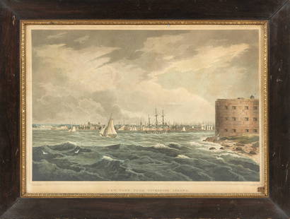
Sold2021HAND-COLORED ETCHING "NEW YORK, FROM GOVERNORS ISLAND"HAND-COLORED ETCHING "NEW YORK, FROM GOVERNORS ISLAND"After William Guy Wall (America, 1792- c. 1864). Engraved by John Hill (America, 1770-1850). Published by Henry I. Megarey, circa 1815.See Sold Price
Sold2019Pair Holstein & Macedonia Hand Colored Etching MapPair of antique hand colored maps. Features a map of Holstein measuring 13" x 9". Housed in frame measuring 16 3/4" x 12 3/4". Also comes with a lithograph map of Macedonia with hand colored embellishSee Sold Price
Sold20211721 Map of America With California as an IslandHistoric Maps 1721 Hand-Colored "A New Map of America from the Latest Observations" with "California" Shown as an Island 1721 Hand-Colored Engraved Western Hemisphere Map titled, "A New Map of AmericaSee Sold Price
Sold20223 PC. FRAMED WORLD MAPS3 PC. FRAMED WORLD MAPS: Comprising; 1- A reduced scale world map based on Mercator's map of 1569. 1- 18th-century hand-colored, A New Map of the Whole World with the Tradewinds According To The LatesSee Sold Price
Sold20211789 MAP OF SOUTH AMERICA BY THOMAS BOWEN1789 Hand colored An Accurate Map of South America from the Best Modern Maps and Charts by Thomas Bowen. Framed,23.5in x 18in. Good condition, some fold marks.See Sold Price
Sold202319thC hand colored etching of Northern New England, possibly VT - possibly a book plate or page from19thC hand colored etching of Northern New England, possibly VT - possibly a book plate or page from a family register - w gift provenance on label in back from 1991 - overall framed size 17"x14 3/4"See Sold Price
Sold2023Hand Colored Etching - "Vue de New York"Hand Colored Etching by Ambroise Louis Garneray (1783-1857). Entitled "Vue de New York". Measures 19.25" tall x 23" wide. All invoices must be paid within 24 hours of the sale. Shipping options are thSee Sold Price
Sold20163 Hand-Colored Engraved New England Maps3 hand-colored engraved New England maps including the states of Rhode Island, Vermont and New Hampshire. "Lon E. from Philada" on lower margin of all three. All most likely engraved by Joseph T. ScotSee Sold Price
Sold2022Herman Moll's New Map of the World - California as an Island!, Ca. 1725Herman Moll's New Map of the World - California as an Island!, Ca. 1725 1p, measuring 13.625" x 8.5", n.p., ca. 1725. A hand-colored map entitled "A New Map of the World according to the New ObservatiSee Sold Price
Sold2023Cary's New Map of London & its Vicinity, 1840Cary's New Map of London and its Vicinity, hand-colored engraving, inscribed "Cary's New Map of London and its Vicinity / Showing the limits of the two penny post-delivery / Published by the AuthoritySee Sold Price
Sold2023C. 1779, ANTARCTICA & CAPTAIN COOK'S TRAVELS MAPAntonio Zatta (Italian fl. 1775-1797), "Emisfero Terrestre Meridionale Tagliato su l'Equatore", circa 1779, hand colored etching on paper depicting map of Antarctica and Captain Cook's travels, unframSee Sold Price
Sold2022TWO HAND-COLORED MAPSTWO HAND-COLORED MAPS1) “A New Map of the West Indies”, J. Bayly. Published by Harrison & Co. for The Geographical Magazine, 1793. 9.5” x 16.75” sight. Framed 17.5” x 24.See Sold Price
Sold2024A framed 1850 Cowperthwait map of GeorgiaA framed, hand colored copy of A New Map of Georgia by Thomas, Cowperthwait & Co. of Philadelphia, published in 1850, and showing towns, roads, railroads, waterways and swamps. A list of steamboat rouSee Sold Price
5 days LeftDoyle New YorkA highly detailed map of New England after the Jansson-Visscher series$200(1 bid)
May 05Tremont AuctionsJohn Speed and Francis Lamb "Map of New England and New York", ca. 1676. Hand colored engraved map$900(3 bids)
5 days LeftDoyle New YorkVaugondy's map of Virginia and Maryland, a reduction of Fry and Jefferson's landmark map$600


![[ARCTIC]. BOWEN, Emanuel. A New & Accurate Map of the North...: [ARCTIC]. BOWEN, Emanuel. A New & Accurate Map of the North Pole. London, [ca. 1746]. Copper-plate map, hand-colored, of the regions north of 50 degrees. The western side of North America is marked Pa](https://p1.liveauctioneers.com/928/318880/171360917_1_x.jpg?height=310&quality=70&version=1707501302)


![[MAP - TOURS] (1 of 1)](https://p1.liveauctioneers.com/292/326828/175962850_1_x.jpg?height=282&quality=70&version=1713473479)


