Sold20163 Hand-Colored Engraved New England Maps3 hand-colored engraved New England maps including the states of Rhode Island, Vermont and New Hampshire. "Lon E. from Philada" on lower margin of all three. All most likely engraved by Joseph T. ScotSee Sold Price
Sold2018France, Spain & Portugal. Inserts of Corsica and rockFrance, Spain & Portugal. Inserts of Corsica and rock of Gibraltar 1868 A.J. Johnson 18" x 26 1/3" Hand colored engraved Map. Published in New York in Johnson's New Illustrated Family Atlas of the WorSee Sold Price
Sold2021Four Antique Hand Colored MapsA grouping of four small framed hand-colored engraved maps to include New England and New York by John Seller, A Mapp of the World by John Seller, Terra Firma, and Moscovia (Moscow) of Russia. All inSee Sold Price
Sold2017Mitchell: Antique Map of New York State & Cities, 1869Title/Content of Map: New York by Mitchell City views on sides Date Printed: 1869 Cartographer: Augustus S. Mitchell Material/Medium: Paper Size: 23 1/3" x 15 1/3" Hand colored steel engraved Map. PubSee Sold Price
Sold2022Homann, Johann Baptist (1661-1774). Nova Anglia Septentrionali Americae implantata AnglorumqueHomann, Johann Baptist (1661-1774). Nova Anglia Septentrionali Americae implantata Anglorumque coloniis florentissimaDouble-page engraved map of New England, hand-colored. Nuremberg, c.1725.See Sold Price
Sold2017Colton: Antique Map of Palestine (Israel), 1861Map: Colton's Palestine (Israel) Date Printed: 1861 Cartographer: J. H. Colton Material/Medium: Paper Size: 14" x 17 1/3" Condition: Excellent Hand colored, steel engraved. Printed in New York. From 'See Sold Price
Sold2017Johnson: Antique Map of China, 1868Map: Johnson's China Date Printed: 1868 Cartographer: A.J. Johnson Material/Medium: Paper Size: 18" x 13 1/3" Condition: Excellent Hand colored, copperplate engraved. Published in New York. From JohnsSee Sold Price
Sold2016Blaeu map of New England and New Yourk 1635Heading: Author: Blaeu, Willem Title: Nova Belgica et Anglia Nova Place Published: Amsterdam Publisher: Date Published: 1635 Description: Copper-engraved map, hand-coloredSee Sold Price
Sold2021Ptolemaeus, Claudius122. Ptolemaeus, Claudius.Asiae VII Tab[ula]. Fine hand-colored engraved map. 14 x 18 inches plus margins, matted, in glass-fronted frame, occasional hand-soiling. Italy, 16th-century [300/400]From PtSee Sold Price
Sold2021Seutter, Matthaüs127. Seutter, Matthaüs.Bohemia Regnum juxta XII. Fine hand-colored engraved map. 19 x 22 inches plus margins, neatly matted, in gilt glass-fronted frame; light wear. Augsburg, Circa 1730s [250/350]See Sold Price
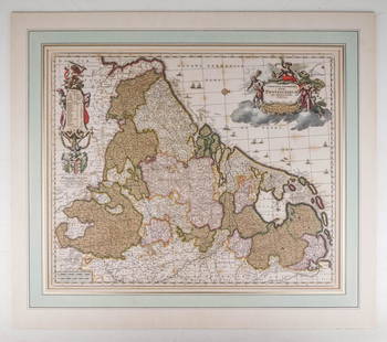
Sold2020Visscher, Claes .Germaniæ Inferioris XVIIVisscher, Claes .Germanie Inferioris XVII Provinciarum. Fine hand colored engraved double-page map. 18-1/2 x 22-1/2 inches plus margins, blank on verso, neatly matted; some browning, generally sound.See Sold Price
Sold2017AntarcticaTitle/Content of Map: Antarctica Date Printed: 1861 Cartographer: J.H. Colton Material/Medium: Paper Size: 14" x 17 1/3" Hand colored, steel engraved. From 'Colton's General Atlas.' Published in New YSee Sold Price
Sold2017Map of the West Indiescirca 1795; "A New Map of the West Indian Islands as they are Possessed by the European Powers," (sic) engraved hand- colored map, by Laurie & Whittle, 18 3/4 x 22 1/2 in.; Purchased from Charles EdwiSee Sold Price
Sold2018Germany's north central region. Insert of Hamburg &Germany's north central region. Insert of Hamburg & Bremen 1861 J.H. Colton 17 1/2" x 13 3/4" Hand colored steel engraved Map. From 'Colton's General Atlas.' Published in New York. Please note that thSee Sold Price
Sold2022PARTIE SEPTENTRIONALE DES POSSESSIONS ANGLOISEEN AMERIQUE. Paris, 1778. Hand colored map showing eastern Canada and New England. Dimensions of frame: H. 26" W. 33 3/4"See Sold Price
Sold202119th Century Print Portland Maine from Cape ElizabethPortland Maine from Cape Elizabeth. Jones and Newman, 128 Fulton St NY. Engraved by E. Whitfield. Hand colored lithograph. American, 19th century. Excellent condition. Framed size H 31-3/4" W 48". SigSee Sold Price
Sold2022Six Atlas of New York and Vicinity, hand colored engraved maps including Sommers, Patterson,Six Atlas of New York and Vicinity, hand colored engraved maps including Sommers, Patterson, Wakefield, Ossining, City Island, and North Salem, 16 3/4" x 13 3/4". Provenance: Originally from Credit SuSee Sold Price
Sold2020Morden, Robert 1701 Hand Col Map of Staffordshire, UKHand Colored Copper Engraved Map Published 1701-08, London for "The New Description and State of England, containing the Mapps of the Counties of England and Wales" by Robert Morden. Light folds as isSee Sold Price
Sold202218th & 19th C. MAPS OF ASIA (3 MAPS)Includes: 2 maps by John Tallis & Co. London / New York, ca. 1850, both matted and framed, including: (1) MAP OF ASIA. Hand colored engraved map. 5 hand colored vignettes. H. 10.25", W. 12.75"; (2) MASee Sold Price
Sold2021Anthony Finley (1784-1836) Map of New JerseyCirca 1920, hand colored, Published by Finley and engraved by Young and Delleker. In a period lemon gilt frame. Dimensions: Sight is 11 1/4" x 8 3/4", the frame 17 1/2" x 14 1/2".See Sold Price
Sold2022Barclay, James C1800 Hand Col Map. Western Hemisphere"The New World or Western Hemisphere" Hand Colored Copper Engraved Map Published C1800 Halifax & Newcastle, England for "Barclay's Universal English Dictionary…" by James Barclay. Maps Engraved by CSee Sold Price
Sold2023Audobon Print - Blue Yellow Backed WarblerHand colored engraving by J.J. Audubon. "Blue Yellow-Backed Warbler". Engraved, Printed, and colored by R. Havell. Plate XV, No. 3. Frame H 30-1/2" W 21-1/8". Print H 19-1/2" W 12-1/4". Condition: NotSee Sold Price
Sold20221831 POCKET MAP OF NEW YORK STATE BY HUMPHREY PHELPS"A Map of the State of New York, with the latest improvements.", pocket map in red leather with gilt title, 16 3/4" x 20 1/4" sheet, 4x9 fold, engraved with handcolored outlines. New York. Scale: 1"=See Sold Price
Sold2021Blaeu, Willem and Jan22. Blaeu, Willem and Jan.Huntingdonensis Comitatus; Huntington Shire. Double-page hand-coloured engraved map. 15-1/2 x 19-3/4 inches plus margins, in glass-fronted gilt and black wooden frame (worn aSee Sold Price
2 days LeftTremont AuctionsJohn Speed and Francis Lamb "Map of New England and New York", ca. 1676. Hand colored engraved map$900(3 bids)
6 days LeftNew England Auctions - Fred GiampietroJacques Barraband - Two Bird Prints from Histoire des Parroquets$50


![Ptolemaeus, Claudius: 122. Ptolemaeus, Claudius.Asiae VII Tab[ula]. Fine hand-colored engraved map. 14 x 18 inches plus margins, matted, in glass-fronted frame, occasional hand-soiling. Italy, 16th-century [300/400]From Pt](https://p1.liveauctioneers.com/1352/192004/96768821_1_x.jpg?height=310&quality=70&version=1611259574)
![Seutter, Matthaüs: 127. Seutter, Matthaüs.Bohemia Regnum juxta XII. Fine hand-colored engraved map. 19 x 22 inches plus margins, neatly matted, in gilt glass-fronted frame; light wear. Augsburg, Circa 1730s [250/350]](https://p1.liveauctioneers.com/1352/192004/96768826_1_x.jpg?height=310&quality=70&version=1611259574)