Sold2019LARGE MIXED EASTERN STATES POSTCARDS, MOST ALL RPPC,LARGE MIXED EASTERN STATES POSTCARDS, MOST ALL RPPC, INCLUDING CATSKILL, N.Y. REGIONS, VASSAR COLLEGE, MIAMI, SOME CUBA, VERMONT, MASS., NEW HAMPSHIRE, SOME CT., MT. WASHINGTON, NEW JERSY & PENNSYLVANSee Sold Price
Sold20241840 Virtue/Willis Map of Northeast US -- The North Eastern Part of the United StatesTitle: 1840 Virtue/Willis Map of Northeast US -- The North Eastern Part of the United States Cartographer: W Hughes Year / Place: 1840 in Old Maps as Virtue Map Dimension (in.): 7.7 x 10.8 in. This isSee Sold Price
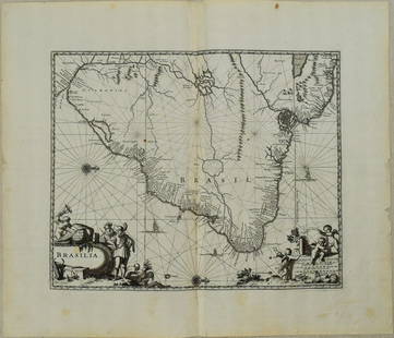
Sold20231671 Ogilby Map of Brazil -- BrasiliaTitle: 1671 Ogilby Map of Brazil -- Brasilia Cartographer: J Ogilby Year / Place: 1671, London Map Dimension (in.): 11.3 X 13.8 in. This is an excellent map of the eastern part of Brazil. There is anSee Sold Price
Sold20181798 Stockdale Map of Eastern United StatesTitle/Content of Map: 1798 Stockdale Map of Eastern United States -- Part of the United States of North America Date Printed: 1798 London Cartographer: J. Stockdale Size: 18.4 x 16.2 in. This antiqueSee Sold Price
Sold2016(17) Souvenir Pennants Many N.Y. & NE U.S.(17) Antique/ vintage souvenir pennants. Several from New York, most are from the north eastern part of the United States of America. Wonderful, unique assortment of pennants. Howe Caverns, Niagra FalSee Sold Price
Sold2022Hughes, W. C1840 Map of the North East USA"The North Eastern Part of the United States" Steel Engraved Map Published C1840 by Virtue, London for "American Scenery..." by N. P. Willis, Illustrated by William Henry Bartlett. Drawn & Engraved bySee Sold Price
Sold2018Map of Eastern States With Part of Canada, 1814Title/Content of Map: Eastern States With Part of Canada Date Printed: 1814 ca. Cartographer: ANONYMOUS Size (inches): 22.75x20.25 Simple map, with some topography. Modern color. Please note that thisSee Sold Price
Sold2022c. 1788 French Map of the Eastern United StatesHistoric Maps c. 1788 Map, "Les Etats Unis de L'Amerique Septentrionale, Partie Orientale" (Eastern Part of the Northern United States of America) by M. (Rigobert) Bonne c. 1788 Map titled, "Les EtatsSee Sold Price
Sold2021Poland. 1784/1785. By William GuthrieTitle: Poland. 1784/1785. By William Guthrie Date/Period: 1784/ 1786 Materials: Copperplate engraved Size: 8 1/2" x 7 3/4" Shows a large Poland in union with Lithuania. A large part of northern EasterSee Sold Price
Sold2022London.- Booth (Charles) Descriptive Map of London Poverty 1889, in four parts, 1889London.- Booth (Charles) Descriptive Map of London Poverty 1889, in four parts covering the North-Western, South-Western, North-Eastern, and South Eastern parts of London, based on Stanford's 'LibrarySee Sold Price
Sold2022[MAPS & ATLASES]. COLTON, J.H. (1800-1893). Colton's New Topographical Map of The States Of[MAPS & ATLASES]. COLTON, J.H. (1800-1893). Colton's New Topographical Map of The States Of Virginia, Maryland and Delaware, Showing Also Eastern Tennessee & Parts Of Other Adjoining States. New York:See Sold Price
Sold2023"Calcutta, India" PosterCalcutta, officially known as Kolkata, is a city located in the eastern part of India, in the state of West Bengal. It is the capital of the state and one of the largest cities in India, with a populaSee Sold Price
Sold2023Jean-Michel Basquiat (American, 1960-1988) Acrylic on CanvasThis lot consists of a large, unframed acrylic on canvas, executed in the street art style of graffiti artist Jean-Michel Basquiat (American, 1960-1988). "SAMO" appears at lower right along with stampSee Sold Price
Sold2022Jean-Michel Basquiat (American, 1960-1988) Acrylic on CanvasThis lot consists of a large, unframed acrylic on canvas, executed in the street art style of graffiti artist Jean-Michel Basquiat (American, 1960-1988). "SAMO" appears at lower right along with stampSee Sold Price
Sold2022Jackson Pollock (American, 1912-1956) -- Acrylic on CanvasThis lot consists of a large unframed acrylic painting on loose canvas, rendered in the abstract expressionist style of modern artist Jackson Pollock (American, 1912-1956). A small, hand-painted inscrSee Sold Price
Sold2022Pablo Picasso (Spanish,1881-1973) - Oil on CanvasThis lot consists of a large oil on canvas painting executed in the modern art style of cubist Pablo Picasso (Spanish,1881-1973). Hand inscription at bottom left reads "Picasso". Overall unframed piecSee Sold Price
Sold2023Jackson Pollock (American, 1912-1956) -- Acrylic on CanvasThis lot consists of a large unframed acrylic painting on loose canvas, rendered in the abstract expressionist style of modern artist Jackson Pollock (American, 1912-1956). A small, hand-painted inscrSee Sold Price
Sold2021Dolph & Stewart 30s Map Columbia County NY Large FolioMap of Columbia County with Eastern part of Greene County, New York, by Dolph & Stewart, circa 1930s. This is a oversized hardcover bound version of what would be tiles from a large wall-mounted mSee Sold Price
Sold2016Eastern States Color Photographs 1990sA large group of about 320 color photographs from a prominent New England collection. They seem to date from the 1990's. They are organized by Geography: Vermont =50, Conway Scenic = 40, New HampshireSee Sold Price
Sold2023Bartholomew, John 1922 Mixed Lot of 5 Large Maps. USA, North America & IndiaNorth America Political, United States - Central and North Eastern States, India North East and the Ganges Valley. Large Lithograph Maps Published 1922 by The Times, London for "The Times Survey AtlasSee Sold Price
Sold2023United States - East Coast / Connecticut - New York Long Island Sound - Eastern PartDescription: United States - East Coast / Connecticut - New York Long Island Sound - Eastern Part. Published at Washington D. C. US COAST AND GEODETIC SURVEY.Material: PaperMeasurement approximate: 30See Sold Price
Sold2023MAP: United States - East Coast. Connecticut - New York. Long Island Sound - Eastern PartDescription: United States - East Coast. . Connecticut - New York. Long Island Sound - Eastern Part. Published at Washington D.C. US Department of Commerce, Environmental Science services AdministratiSee Sold Price
Sold2019Imperii Romani Distracta pars Orientalis. Roman Empire,TITLE/CONTENT OF MAP: 'Imperii Romani Distracta, pars Orientalis [Roman Empire, eastern part]' DATE PRINTED: 1789 IMAGE SIZE: Approx 36.0 x 25.0cm, 14 x 9.75 inches (Large); Please note that this is aSee Sold Price
Sold2019Imperia Antiqua, pars Orientalis. Empire of AlexanderTITLE/CONTENT OF MAP: 'Imperia Antiqua, pars Orientalis [The Empire of Alexander the Great, eastern part]' DATE PRINTED: 1789 IMAGE SIZE: Approx 36.5 x 25.5cm, 14.25 x 10 inches (Large); Please note tSee Sold Price
Jun 01Galerie Moenius AGEXTREMELY RARE RELIQUARY ICON WITH SILVER OKLAD AND INSET SILVER CROSS SHOWING THE CRUCIFIXION OF€5,000
2 days LeftJasper521894 Johnson Map of New England States -- Johnson's Section Map and Index of the New England States$80
Featured3 days LeftJasper52West India Islands & Central American States. Caribbean. STANFORD 1904 old map$60
Jun 07TimeLine Auctions Ltd.Natural History - Large Polished Copal Amber with Termite Nest and Termites£5
May 18Alice Callahan Auction HouseLLADRO PORCELAIN FIGURINE "TRANQUILITY" #6677 14"T 9"W 5" D$200(6 bids)


![[MAPS & ATLASES]. COLTON, J.H. (1800-1893). Colton's New Topographical Map of The States Of: [MAPS & ATLASES]. COLTON, J.H. (1800-1893). Colton's New Topographical Map of The States Of Virginia, Maryland and Delaware, Showing Also Eastern Tennessee & Parts Of Other Adjoining States. New York:](https://p1.liveauctioneers.com/197/265299/138516337_1_x.jpg?height=310&quality=70&version=1666051328)


![Imperii Romani Distracta pars Orientalis. Roman Empire,: TITLE/CONTENT OF MAP: 'Imperii Romani Distracta, pars Orientalis [Roman Empire, eastern part]' DATE PRINTED: 1789 IMAGE SIZE: Approx 36.0 x 25.0cm, 14 x 9.75 inches (Large); Please note that this is a](https://p1.liveauctioneers.com/5584/139429/70692722_1_x.jpg?height=310&quality=70&version=1554845662)
![Imperia Antiqua, pars Orientalis. Empire of Alexander: TITLE/CONTENT OF MAP: 'Imperia Antiqua, pars Orientalis [The Empire of Alexander the Great, eastern part]' DATE PRINTED: 1789 IMAGE SIZE: Approx 36.5 x 25.5cm, 14.25 x 10 inches (Large); Please note t](https://p1.liveauctioneers.com/5584/156033/78749880_1_x.jpg?height=310&quality=70&version=1575421548)


![[WALL MIRROR]. American - Federal Gilt Girandole Circular W... (1 of 1)](https://p1.liveauctioneers.com/928/328184/176813708_1_x.jpg?height=282&quality=70&version=1714496988)
