Sold20191835 Burr Map of Evolving Cartography of the GreatReserve Reduced! Map Title/Content: 1835 Burr Map of Evolving Cartography of the Great Lakes -- A Map, Exhibiting the Relative Positions of Lake Erie & Michigan According to Recent Surveys [on sheet wSee Sold Price
20181835 ATLAS MAPS Cartography Navigation Voyages1835 ATLAS MAPS Cartography Navigation Voyages Illustrated Monin French Petit Charles V. Monin was a 19th-century French cartographer who was one of the first Europeans to print maps under the printinSee Sold Price
Sold20181835 ATLAS MAPS Cartography Navigation Voyages Illustra1835 ATLAS MAPS Cartography Navigation Voyages Illustrated Monin French Petit Charles V. Monin was a 19th-century French cartographer who was one of the first Europeans to print maps under the printinSee Sold Price
Sold20181835 EXQUISITE French ATLAS Cartography MAPS Navigation1835 EXQUISITE French ATLAS Cartography MAPS Navigation Voyages Illustrated Monin Charles V. Monin was a 19th-century French cartographer who was one of the first Europeans to print maps under the priSee Sold Price
Sold2023Civil War Era Itemsitems to include: Epaulette, Solider tin type, brass bleeder in case, pewter snuff box, powder horn with dog, early 1800's fork in leather case, Burr's map of New York State 1835 in poor condition, 18See Sold Price
Sold20211829 County Map of Rensselaer County NY by David H BurrMap of the County of Rensselaer from 1829, by David H Burr. Rensselaer County sits on the bank of the Hudson River and was founded in 1791. Wooden frame with gold border. Great local map. DimensionsSee Sold Price
Sold20241835 Visible Heavens in April, May and June, E. H. BurrittGreat hand-colored map of the visible constellations in the second quarter of the year by Elijah H. Burritt. These are from Burritt’s 1835 edition of his atlas which, due to the rarity of the 18See Sold Price
Sold20231835 Visible Heavens in April, May and June, E. H. BurrittGreat hand-colored map of the visible constellations in the second quarter of the year by Elijah H. Burritt. These are from Burritt’s 1835 edition of his atlas which, due to the rarity of the 1See Sold Price
Sold20241755 BELLIN MAP OF THE GREAT LAKESThis iconic Bellin's map of the Great Lakes region dominated the cartography of that region for many years with four non-existent islands in Lake Superior, measuring 17" x 21 1/4" at sight. ConditionSee Sold Price
Sold2023A 17th Century Map, Great Britain, Wenzel HollarA map surrounded by various panels showing historic events, center creased. Dimensions: Sight is 11 1/2" x 13 3/4", the frame 17 1/4" x 18 3/4" See Sold Price
Sold2022JOHN SPEED 17TH C. MAP, GREAT BRITAIN.John Speed map, ”The Kingdome of Great Britaine and Ireland,” engraved by J. Hondius, printed by Sudbury and Humble, London, 1610, with insets of London, Edinburgh, and the Orkney Islands,See Sold Price
Sold20221835 Great Britain 6 Pence Reeded Edge Proof, NGC PF66- TOP POP!1835 Great Britain 6 Pence Reeded Edge Proof, NGC PF66. Certification #: 2880326-003** TOP POP- NONE FINER **See Sold Price
Sold2023 [MAPS - GREAT LAKES REGION]. VAUGONDY, Gilles Robert de (16...[MAPS - GREAT LAKES REGION]. VAUGONDY, Gilles Robert de (1688-1766). Les Lacs du Canada et Nouvelle Angleterre… Paris, 1749. Engraved map (229 x 318 mm) with hand-colored outlining, appearing toSee Sold Price
Sold2016Burr Map of Queens, Kings & Richmond.Map of Queens, Kings & Richmond. David H. Burr (1803-1875). Engraving with original hand color. Ithaca, NY: Stone Clark, 1839. 17 1/4 x 22 1/4 inches sheet, 22 x 27 inches framed. This map from The AtSee Sold Price
Sold20211683 Sanson Map Great Lakes to Newfoundland -- LeTitle: 1683 Sanson Map Great Lakes to Newfoundland -- Le Canada, ou Nouvelle France, &c. Tiree de diverses Relations des Francois, Anglois, Hollandois, &c. Cartographer: N Sanson Year / Place: 1683 c.See Sold Price
Sold2017Jules Moigniez (French 1835 - 1894) Great Horned OwlJules Moigniez (French 1835 - 1894) Great Horned Owl Bronze with dark brown patination Signed J. Moigniez at base 29.5 in. h. x 44 in. w.See Sold Price
Sold2017d'Anville / Santini: Antique Map of Great Lakes, 1775Map: Partie Occidentale du Canada et Septentrionale de la Louisiane Cartographer: d'Anville / Santini Place & Date: Venice / 1775 Size: 22 1/4" x 19" Condition: outline color; light overall age toningSee Sold Price
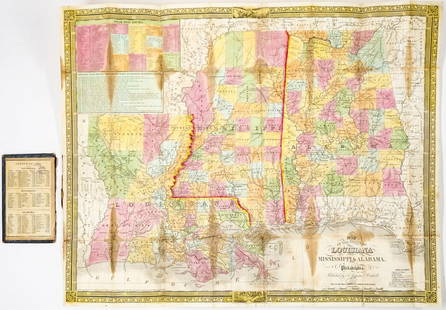
Sold20241835 Mitchell Map Louisiana, Mississippi, Alabama1835 Mitchell Map of Louisiana, Mississippi and Alabama -- Map of the States of Louisiana, Mississippi & Alabama. Cartographer: S Mitchell, 1835, Philadelphia. Map Dimension (in.): 18.25 x 22.625 inchSee Sold Price
Sold20201783 Cary Map of Great Britain and Ireland -- A Map ofTitle: 1783 Cary Map of Great Britain and Ireland -- A Map of Great Britain and Ireland with all the Adjacent Isles. Year/Place: 1783, London Cartographer: J Cary Size: 10.8 X 8.8 in. Additional InforSee Sold Price
Sold2020Map of Great Britain, Ireland, Russia PlusMap of Great Britain and Ireland PLUS Western Part of Russia and Denmark, Sweden and Norway on verso Two maps on one sheet. (back to back). Hand colored. [See photSee Sold Price
Sold2019Poirson & Tardieu l'Aine Map of Great Britain, 1803**Originally Listed At $150** Cartographer J.B. (Jean-Baptiste) Poirson (French, 1760-1831), Engraver: Jean Baptiste Pierre Tardieu l'Aine (French, 1746-1816). "Angleterre Ecosse et Irlande, on RoyaumSee Sold Price
Sold20191835 Malte-Brun map of Switzerland -- SwitzerlandTitle: 1835 Malte-Brun map of Switzerland -- Switzerland Date: 1834, Boston Cartographer: M. Malte-Brun / S. Walker Size: 9.3 x 7.5 in. Additional Information: An attractive and highly detailed map wiSee Sold Price
Sold2015WILLIAM STANLEY HASELTINE (MA/PA/Italy, 1835-1900) -WILLIAM STANLEY HASELTINE (MA/PA/Italy, 1835-1900) - "Great Head, Mt. Desert Island, Maine", oil on canvas, initialed lower left, titled verso, with F.W. Devoe & Co. stencil on canvas, in the originalSee Sold Price
Sold2015Jules Moigniez bronze sculptureJules Moigniez (French 1835-1894)- Great Horned Owl- bronze sculpture, signed J. Moigniez at base. 34''hSee Sold Price
2 days LeftJasper521641 MAP of ITALY antique authentic TERRITORIUM BONONIENSE IL BOLOGNESE original$160
3 days LeftJasper52Septentrionales Regiones. Northern Europe. Scandinavia Baltics. MÜNSTER 1572 map$1,000
Oct 27Schilb Antiquarian Rare Books1871 Chicago FIRE Great RARE MAP Conflagration 1871 Colbert Illustrated Chapin Gulick$1(1 bid)
Oct 12JM Hobby Supply and Railroad Artifact AuctionsWest Virginia Central and Pittsburg Railway Annual Report-1882$30(1 bid)
Oct 12JM Hobby Supply and Railroad Artifact AuctionsGreat Lakes Transit Corporation 1925 Great Lakes Cruise Brochure and Timetable$20(1 bid)
Oct 12JM Hobby Supply and Railroad Artifact AuctionsCanadian National RR Condensed and Suburban Service Timetables-1960s-1970s$10


![[MAPS - GREAT LAKES REGION]. VAUGONDY, Gilles Robert de (16...: [MAPS - GREAT LAKES REGION]. VAUGONDY, Gilles Robert de (1688-1766). Les Lacs du Canada et Nouvelle Angleterre… Paris, 1749. Engraved map (229 x 318 mm) with hand-colored outlining, appearing to](https://p1.liveauctioneers.com/928/301544/160920958_1_x.jpg?height=310&quality=70&version=1694462960)