Sold20231862 Civil War, Coltons New Topographical Map of The States of Virginia, Maryland and DelawareHistoric Maps 1862 Civil War "Colton's New Topographical Map of The States of Virginia, Maryland and Delaware" Hardcover Folio 1862-Dated Civil War Period, Hand-colored 45.25" x 31.5" Folding Map titlSee Sold Price
Sold2022[MAPS & ATLASES]. COLTON, J.H. (1800-1893). Colton's New Topographical Map of The States Of[MAPS & ATLASES]. COLTON, J.H. (1800-1893). Colton's New Topographical Map of The States Of Virginia, Maryland and Delaware, Showing Also Eastern Tennessee & Parts Of Other Adjoining States. New York:See Sold Price
Sold2022(TEXAS.) Joseph Hutchins Colton. New Map of the State of Texas Compiled from J. de Cordova's Large(TEXAS.) Joseph Hutchins Colton. New Map of the State of Texas Compiled from J. de Cordova's Large Map. Double-page lithographed map of Texas with attractive original hand-color by county. 18x27 incheSee Sold Price
Sold20181859 Clark & Tackabury Antique Connecticut Wall MapTitle/Content of Map: 1859 Clark & Tackabury Connecticut Wall Map -- Clark & Tackabury's New Topographical Map of the State of Connecticut Date Printed: 1859 Philadelphia Cartographer: Clark and TackaSee Sold Price
Sold2021Connecticut44. Connecticut.Clark & Tackabury's New Topographical Map of the State of Connecticut. Fine hand-colored map in 24 sections. 56-1/2 x 72 inches, linen-backed, gilt-lettered cloth portfolio with stringSee Sold Price
Sold2018Antique Clark & Tackabury Connecticut Map,1859Antique Clark & Tackabury's, 1859, "New Topographical Map of the State of Connecticut", attached to wooden rod with acorn finials. Note: Complete and very informative colored wall map of Connecticut,See Sold Price
Sold20151876 Colton's “New Township Map of the State of1876 Colton's “New Township Map of the State of Florida” folding pocket map on boards, (tears on original crease lines)See Sold Price
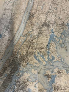
Sold2023Group lot of NEW YORK State Topographical MapsGroup lot of NEW YORK State Topographical Maps, maps measure 17 x 21 inches, wear consistent with age and use. not framed. Art, wall art, artwork, home decor, maps, topographic, topography, New York SSee Sold Price
Sold2022Group lot of NEW YORK State Topographical MapsGroup lot of NEW YORK State Topographical Maps, maps measure 17 x 21 inches, wear consistent with age and use. not framed. Art, wall art, artwork, home decor, maps, topographic, topography, New York SSee Sold Price
Sold2020Map of the Civil War, 1863Heading: (Civil War) Author: Perrine, Charles O. and Capt. John S. Bishop Title: Perrine's New Topographical War Map of the Southern States with a Chronology of the Great Rebellion [with] A Concise HiSee Sold Price
Sold20231893 Civil War Map of the South -- Section of G. Woolworth Colton's New Guide Map of the UnitedTitle: 1893 Civil War Map of the South -- Section of G. Woolworth Colton's New Guide Map of the United States and Canada with Railorads, Counties, etc. 1863. Used by General Grant in Marking the PropoSee Sold Price
Sold2022J.H. COLTON (1800-1893) A MAP, "New Map of the State ofJ.H. COLTON (1800-1893) A MAP, "New Map of the State of Texas," NEW YORK, CIRCA 1855, hand-colored lithograph on paper, "Compiled from J. de Cordova's large Map," and, "Published by J.H. Colton & Co.,See Sold Price
Sold20201862 Colton Map of the United States -- Colton's NewTitle/Content of Map: 1862 Colton Map of the United States -- Colton's New Railroad & County Map of the United States the Canadas &c. Cartographer: J Colton Year/Place: 1862, New York Size: 33.1 X 39See Sold Price
Sold20241865 United States Map by ColtonTitle: 1865 United States Map by Colton Date/Period: 1865 Materials: Hand colored steel engraved Size: 12 x 9" The United States, with Mexico and the Caribbean, 1865 By J. H. Colton. New York. Hand-coSee Sold Price
Sold2019Colton's Ohio Map [Midwestern States]Colton's Ohio Map. J. H. Colton Cartographer. Inset of 'Vicinity of Cleveland' lower right. Published by J. H. Colton, New York. Stamped 'Entered according to Act of Congress in the Year 1855 by J. H.See Sold Price
Sold2019Colton's Virginia Map [Southern States]Colton's Virginia Map; Delaware on the right, Maryland on the left. J. H. Colton Cartographer. Published by J. H. Colton, New York. Stamped 'Entered according to Act of Congress in the Year 1855 by J.See Sold Price
Sold2019Colton's Iowa Map [Midwestern States]Colton's Illinois Map. J. H. Colton Cartographer. Published by J. H. Colton, New York. Stamped 'Entered according to Act of Congress in the Year 1855 by J. H. Colton and Co. in in the Clerks Office ofSee Sold Price
Sold2019Colton's Delaware/Maryland Map [Southern States]Colton's Delaware and Maryland Map; Delaware on the right, Maryland on the left. J. H. Colton Cartographer. Published by J. H. Colton, New York. Insert of 'District of Columbia' lower left. Stamped 'ESee Sold Price
Sold2019Colton's Missouri Map [Midwestern States]Colton's Missouri Map. J. H. Colton Cartographer. Inset of 'Vicinity of St. Louis' upper right. Published by J. H. Colton, New York. Stamped 'Entered according to Act of Congress in the Year 1855 by JSee Sold Price
Sold2018J. H. Colton's Map of United StatesIncluding US, British Provinces, Mexico, and West Indies. Published by J.H. Colton, New York, 1853. 59" x 53".See Sold Price
Sold2019Colton's Maine Map [N. Atlantic States]Colton's Maine Map. J. H. Colton Cartographer. Published by J. H. Colton, New York. Stamped 'Entered according to Act of Congress in the Year 1855 by J. H. Colton and Co. in in the Clerks Office of thSee Sold Price
Sold20221890 Township Map of the State of Maine.Published by G.W. & C.B. Colton, New York, 37 x 30.5 inches, sight. Beautifully framed, 45 x 39 inches.See Sold Price
Sold2020Early United States Roll-Up MapEarly United States roll-up map. Published by J. H. Colton / New York / 1853. 44 1/2" x 36".See Sold Price
Sold2022(NEW YORK.) Colton family. Colton's Railroad & Township Map of the State of New York, with Parts of(NEW YORK.) Colton family. Colton's Railroad & Township Map of the State of New York, with Parts of the Adjoining States and Canada. Hand-colored engraved pocket map of New York within a decorative foSee Sold Price
5 days LeftJasper521890 c. Clemens Wooden Puzzle Map of the US -- Clemens' Silent Teacher Dissected Map of the United$240
5 days LeftJasper52New Map of That Portion of North America Exhibiting the United States and Territories...Mexico...$360
2 days LeftGreat Estates Auctioneers & Appraisers1850 ROBERT HORNER MAP OF NEW JERSEY & ADJOINING$125(2 bids)
May 16Potter & Potter Auctions[PICTORIAL MAPS – TRAVEL]. Three Pictorial Maps. 1940s/50s....$150
5 days LeftJasper521875 Warner & Beers United States Railroad Map -- Railroad Map of the United States$140
May 09Hunt and Peck Estate Services, Inc.1794 Laurie & Whittle after Thomas Jefferys Map Of The United States Of America$340(1 bid)
May 16Potter & Potter AuctionsBOURNE, Emma (1906 – 1986). America – A Nation of One Peopl...$125(1 bid)
1 day LeftTrillium Antique Prints & Rare BooksBonne - Map of the Eastern Coast of North America$85(3 bids)
1 day LeftRapid Estate Liquidators and Auction Gallery1856 Mississippi Map & Info Published By J.H. Colton & Co. No.172 William St. New York$45
5 days LeftJasper521865 Colton Map of US Southwest -- Colton's Map of California, Nevada, Utah, Colorado, Arizona & New$160


![[MAPS & ATLASES]. COLTON, J.H. (1800-1893). Colton's New Topographical Map of The States Of: [MAPS & ATLASES]. COLTON, J.H. (1800-1893). Colton's New Topographical Map of The States Of Virginia, Maryland and Delaware, Showing Also Eastern Tennessee & Parts Of Other Adjoining States. New York:](https://p1.liveauctioneers.com/197/265299/138516337_1_x.jpg?height=310&quality=70&version=1666051328)


![Map of the Civil War, 1863: Heading: (Civil War) Author: Perrine, Charles O. and Capt. John S. Bishop Title: Perrine's New Topographical War Map of the Southern States with a Chronology of the Great Rebellion [with] A Concise Hi](https://p1.liveauctioneers.com/642/164280/82938913_1_x.jpg?height=310&quality=70&version=1584491135)


![Colton's Ohio Map [Midwestern States]: Colton's Ohio Map. J. H. Colton Cartographer. Inset of 'Vicinity of Cleveland' lower right. Published by J. H. Colton, New York. Stamped 'Entered according to Act of Congress in the Year 1855 by J. H.](https://p1.liveauctioneers.com/5755/154409/77936939_1_x.jpg?height=310&quality=70&version=1573094011)
![Colton's Virginia Map [Southern States]: Colton's Virginia Map; Delaware on the right, Maryland on the left. J. H. Colton Cartographer. Published by J. H. Colton, New York. Stamped 'Entered according to Act of Congress in the Year 1855 by J.](https://p1.liveauctioneers.com/5755/154409/77936948_1_x.jpg?height=310&quality=70&version=1573094011)
![Colton's Iowa Map [Midwestern States]: Colton's Illinois Map. J. H. Colton Cartographer. Published by J. H. Colton, New York. Stamped 'Entered according to Act of Congress in the Year 1855 by J. H. Colton and Co. in in the Clerks Office of](https://p1.liveauctioneers.com/5755/154409/77936937_1_x.jpg?height=310&quality=70&version=1573094011)
![Colton's Delaware/Maryland Map [Southern States]: Colton's Delaware and Maryland Map; Delaware on the right, Maryland on the left. J. H. Colton Cartographer. Published by J. H. Colton, New York. Insert of 'District of Columbia' lower left. Stamped 'E](https://p1.liveauctioneers.com/5755/154409/77936946_1_x.jpg?height=310&quality=70&version=1573094011)
![Colton's Missouri Map [Midwestern States]: Colton's Missouri Map. J. H. Colton Cartographer. Inset of 'Vicinity of St. Louis' upper right. Published by J. H. Colton, New York. Stamped 'Entered according to Act of Congress in the Year 1855 by J](https://p1.liveauctioneers.com/5755/154409/77936941_1_x.jpg?height=310&quality=70&version=1573094011)

![Colton's Maine Map [N. Atlantic States]: Colton's Maine Map. J. H. Colton Cartographer. Published by J. H. Colton, New York. Stamped 'Entered according to Act of Congress in the Year 1855 by J. H. Colton and Co. in in the Clerks Office of th](https://p1.liveauctioneers.com/5755/154409/77936952_1_x.jpg?height=310&quality=70&version=1573094011)


![[PICTORIAL MAPS – TRAVEL]. Three Pictorial Maps. 1940s/50s.... (1 of 4)](https://p1.liveauctioneers.com/928/325952/175495561_1_x.jpg?height=282&quality=70&version=1712935174)


