Sold2019Rare map of Provence, France, with multiple city views.Title/Content of Map: Rare map of Provence, France, with multiple city views. Including Avignon, Nice, Marseille Date: 1717 Cartographer: Feuille Size: 7.6x10.6” Provenance: Amsterdam Original hanSee Sold Price
Sold20201765 Paris FRANCE City View Maps Architecture Art1765 Paris FRANCE City View Maps Architecture Art Piganiol ILLUSTRATED A rare geographical study of France by Piganiol! Piganiol de la Force was an 18th-century French author known almost exclusivelySee Sold Price
Sold20201765 Paris FRANCE City View Maps Architecture Art1765 Paris FRANCE City View Maps Architecture Art Piganiol ILLUSTRATED A rare geographical study of France by Piganiol! Piganiol de la Force was an 18th-century French author known almost exclusivelySee Sold Price
2018Rare map of the 17 Provence’s. Belgium, Netherlands andReserve Reduced! Title/Content of Map: Rare map of the 17 Provence’s. Belgium, Netherlands and Luxembourg Date: 1717 Size: 7.6x10.6” Views of 15 cities including Amsterdam, Brussels and LuxembourgSee Sold Price
Sold2019Rare map of Hungry with 20 city viewsTitle/Content of Map: Rare map of Hungry with 20 city views Date: 1717 Cartographer: Feuille Size: 7.6x10.6” Provenance: Amsterdam Additional Info: Original hand color. Reserve: $70.00 Shipping: DSee Sold Price
Sold2019Rare map of Catalonia with 13 city views includingTitle/Content of Map: Rare map of Catalonia with 13 city views including Barcelona Date: 1717Cartographer: by FeuilleSize: 7.6x10.6” Provenance: Amsterdam original hand color Reserve: $95.00 ShippinSee Sold Price
Sold20191750 Illustrated French Travel Guide FRANCE City Views1750 Illustrated French Travel Guide FRANCE City Views Mont St Michel Marseille Georges-Louis Le Rouge was an 18th-century French author and voyager who published a French travel guide filled with expSee Sold Price
Sold20191750 Illustrated French Travel Guide FRANCE City Views1750 Illustrated French Travel Guide FRANCE City Views Mont St Michel Marseille Georges-Louis Le Rouge was an 18th-century French author and voyager who published a French travel guide filled with expSee Sold Price
Sold2019Rare map of the Wallonia region of Belgium with cityTitle/Content of Map: Rare map of the Wallonia region of Belgium with city views of Brussels and other cities. Date: 1717Cartographer: by FeuilleSize: 7.6x10.6” Provenance: Amsterdam original hand cSee Sold Price
Sold2019Rare map of French region of Lunguedoc with 12 cityTitle/Content of Map: Rare map of French region of Lunguedoc with 12 city views including Montpelier. Date: 1717 Cartographer: Feuille Size: 7.6x10.6” Provenance: Amsterdam Additional Info: OriginalSee Sold Price
Sold20181850 History of New York O’Callaghan Illustrated City1850 History of New York O’Callaghan Illustrated City Views MAPS Quakers Slaves Emund Bailey O’Callaghan was a 19th-century Irish-born journalist who is most-remembered for his iconic work on theSee Sold Price
Sold2021c 1730 Seutter Map: Novi Belgii, in America ...Historic Maps c. 1730 Historic Rare Earlier State of Seutter's Important American Northeast Map & New York City Restitutio View c. 1730 Hand-Colored Copper-Engraved Map titled, "Recens Edita totius NoSee Sold Price
Sold2021Johannes Cloppenburg Nova Galliae TabulaDESCRIPTION: Johannes Cloppenburg Nova Galliae Tabula. Map of France with border depicting views of French cities and inhabitants. Geographical content based on Blaeu, 1607. With Cloppenburg's imprintSee Sold Price
Sold20181788 France Dulaure Atlas MAPS Provence Poitou Castles1788 France Dulaure Atlas MAPS Provence Poitou Castles French Revolution era Jacques-Antoine Dulaure was an 18th-century French historian known for his descriptive work on the important geographic plaSee Sold Price
Sold2021Bowles View of Philadelphia, Heap and ScullRare 1778 Engraved map of Colonial Philadelphia after George Heap (1714-1752) and Nicholas Scull (1687-1761), published by Carington Bowles, London, 1778: AN EAST PERSPECTIVE VIEW OF THE CITY OF PHILASee Sold Price
Sold2017Currier & Ives: San Francisco Birds Eye View Map, 1878Map: The City of San Francisco Birds Eye View Looking from the Bay South-West Cartographer: Currier & Ives Date: 1878 Size: 11.4 x 17.75 inches This is a rare view of San Francisco of the late 1800s lSee Sold Price
Sold2023MAP, France, AaLyon, France. Pieter van der Aa, Lyon, Capitale du Lyonnois, 1710 (circa). Black & White. This rare and beautifully engraved view of Lyon is surrounded by an ornate architectural border, which was priSee Sold Price
Sold20221698 1ed PARIS France MAP Palais Royal Hotel de Ville Tuileries Garden Brice1698 1ed PARIS France MAP Palais Royal Hotel de Ville Tuileries Garden Brice Germaine Brices Description of Paris was one of the earliest travel guides on the city of Paris. It features charming, foldSee Sold Price
Sold2018Vienne En Avstriche."Title/Content of Map: Vienne En Avstriche." Cartographer: Jollain, Francis, The Elder Height (inches): 12 Width (inches): 21.5Year: 1685 A rare and handsome city birdseye view showing the Austrian capSee Sold Price
Sold20221722 Paris FRANCE Architecture Illustrated Notre Dame1722 Paris FRANCE Architecture Illustrated Notre Dame MAPS City Plans Force 2v A rare geographical study of France by Piganiol! Piganiol de la Force was an 18th-century French author known almost exclSee Sold Price
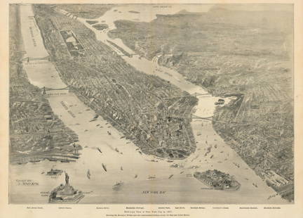
Sold2021New York Bay, 1897Bird’s-Eye View of New York City in 1897This small but intensely detailed map of the city of New York depicts a near snapshot of what could be seen from a rare objective-above. With Burroughs aSee Sold Price
Sold2022Orleans - Gertrude Smith Collection Postal ViewsRemembering Orleans From the Gertrude Smith Collection of Postal Views - Rare Dated: Circa 1920's Binding Stiff Paper Covers Subject: FranceSee Sold Price
Sold2021Lochhead (Pub) 1811 Rare Map. FranceCopper Engraved Map Published 1811 by William Lochhead, Berwick for "Modern Geography: And a Compendious General Gazetteer" Rare. Folds as issued. Paper Size: 11 x 10 inch (28 x 26cm) Good ConditionSee Sold Price
Sold2017Mallet: Antique Map, City View of Cuzco, Peru, 1683Title: 'Cusco' Decorative view of the city of Cuzco, Peru. Date Printed: 1683 Image Size: Approx Overall page size 13 x 21cm approximately (5 x 8 inches); image size 10.5 x 14.5cm approximately (4 x 5See Sold Price
15 hrs LeftTrillium Antique Prints & Rare BooksBraun & Hogenberg, pub. 1575 - View of Cairo, Egypt$100
15 hrs LeftTrillium Antique Prints & Rare BooksBraun & Hogenberg, pub. 1575 - View of Stockholm, Sweden$100
15 hrs LeftTrillium Antique Prints & Rare BooksBraun & Hogenberg, pub. 1575 - View of Canterbury, England$100
15 hrs LeftTrillium Antique Prints & Rare BooksBraun & Hogenberg, pub. 1575 - View of Brussels, Belgium$100
15 hrs LeftTrillium Antique Prints & Rare BooksBraun & Hogenberg, pub. 1575 - View of Zurich, Switzerland$100
15 hrs LeftTrillium Antique Prints & Rare BooksBraun & Hogenberg, pub. 1575 - View of Utrecht, Netherlands$100
May 04Trillium Antique Prints & Rare BooksBraun & Hogenberg, pub. 1575 - View of Jerusalem, Israel$100(1 bid)
May 04Trillium Antique Prints & Rare BooksBraun & Hogenberg, pub. 1575 - View of Rotterdam, Netherlands$100
May 04Trillium Antique Prints & Rare BooksBraun & Hogenberg, pub. 1575 - View of Cusco, Peru and Mexico$100
May 04Trillium Antique Prints & Rare BooksBraun & Hogenberg, pub. 1575 - View of Innsbruck, Germany$100
8 hrs LeftJeschke Jadi Auctions Berlin GmbHPlan von St. Petersburg 1854. Gestochene Karte mit 18 Stadtansichten. Aus: Meyer's grosser€200
May 04Trillium Antique Prints & Rare BooksVaillant - 4 Views of South America: Peru, Bolivia, Chili$75
15 hrs LeftTrillium Antique Prints & Rare BooksPtolemy & Magini, pub. 1620 - Map of France / Verso: Map of Germany$50
May 09Hunt and Peck Estate Services, Inc.Jacques Nicolas Bellin Map Of Western Part Of New France Or Canada$200(1 bid)


![[MAP - TOURS] (1 of 1)](https://p1.liveauctioneers.com/292/326828/175962850_1_x.jpg?height=282&quality=70&version=1713473479)


