Sold2024Ptolemy & Magini, pub. 1620 - Map of the British Isles (England, Scotland, Ireland) / Verso: Map ofThis early map engraving is from Claudius Ptolemaeus (Ptolemy) and Giovanni Antonio Magini's Geografia cio? Descrittione Universale della Terra Partita in due volumni, Nel Primo de' quali si contengonSee Sold Price
Sold2024Ptolemy & Magini, pub. 1620 - Map of India and Surrounding Islands (East Indies)This early map engraving is from Claudius Ptolemaeus (Ptolemy) and Giovanni Antonio Magini's Geografia cio? Descrittione Universale della Terra Partita in due volumni, Nel Primo de' quali si contengonSee Sold Price
Sold2024Ptolemy & Magini, pub. 1620 - Map of Sardinia & SicilyThis early map engraving is from Claudius Ptolemaeus (Ptolemy) and Giovanni Antonio Magini's Geografia cio? Descrittione Universale della Terra Partita in due volumni, Nel Primo de' quali si contengonSee Sold Price
Sold2024Ptolemy & Magini, pub. 1620 - Double Hemisphere Map of the WorldThis early map engraving is from Claudius Ptolemaeus (Ptolemy) and Giovanni Antonio Magini's Geografia cio? Descrittione Universale della Terra Partita in due volumni, Nel Primo de' quali si contengonSee Sold Price
Sold2019Gallia Color Map [France]Galliae Regni Potentiss Color Map with written description in Latin on verso. Map of France with boarders to Germany, Spain and Italy. Appears to be a page from an atlas. Undated. Measures 14 in. x 20See Sold Price
Sold2018Ptolemy/Magini: Antique Map of France, Germany, 1598Map: Tavola della Gallia, Terza dell'Europa Tavola della Gran Germania, Quarta dell'Europa Cartographer: Magini / Porro / Galignani Fratelli Place & Date: Venice / 1598 Size: 6 5/8" x 5 1/8" (maps); 7See Sold Price
Sold2024Brockhaus (Pub) 1880's Lot of 21 Antique MapsIncl Balkans, World, Switzerland, Italy, Great Britain, France, Germany, Ethnographic Maps, Europe, Africa, Australia/Polynesia, Asia, South America, Hungary, Scandinavia and others. Lithograph Maps PSee Sold Price
Sold2021Tallis, John (Pub) 1852 Lot of 12 European MapsIncl Northern Italy, Southern Italy, Brussels, Germany, Spain and Portugal, Prussia, Europe Continent, Greece, Denmark, Belgium, Holland and France. Steel Engraved Maps with Original Outline Hand ColoSee Sold Price
Sold2024Blackie (Pub) 1882 Lot of 20 Folio European MapsIncl England, Ireland, Scotland, France, Spain/Portugal, Turkey/Greece, Russia, Scandinavia, Germany etc. Lithograph Maps Published 1882 by Blackie & Son, London for "The Comprehensive Atlas & GeograpSee Sold Price
Sold2022Brockhaus (Pub) 1890's Lot of 20 Antique MapsIncl Mozambique, Italy, Portugal, Germany, Japan, France, Indian Ocean, Wind Chart, etc. Lithograph Maps Published 1892-98 by F. A. Brockhaus, Leipzig for "Brockhaus' Konversations-Lexikon" by VariousSee Sold Price
Sold2021Rare Original 1950s Air France 8-Panel Map Poster BouchBoucher, Lucien 1889 - 1971Air France - Le Plus Grande Reseau du Monde (Billboard)Lithograph 1959102.3 x 165.3 in. (260 x 420 cm)Printer: Perceval, ParisCondition Details: (A-) in 8 panels, small tearSee Sold Price
Sold2023WWII U.S MILITARY WAR MAPS OF FRANCE/BELGIUM - (9)171281 WWII U.S MILITARY WAR MAPS OF FRANCE/BELGIUM - (9) WWII U.S. military war maps of France/Belgium to include one sheet 79 Defenses Vierville-Sur-Mer France (12500) war map, two sheet 31/18 S.E.See Sold Price
Sold2023WWII U.S. MILITARY FIELD MAPS 1939-1945 - (4)170301 WWII U.S. MILITARY FIELD MAPS 1939-1945 - (4) WWII U.S. military field maps 1939- 1945 to include one East and West Omaha beach scanned "Bigot" Field maps, one France (12500) Isigny field map,See Sold Price
Sold2015Jansson (Jan) - [Atlas Novus: Germany],single vol. lacking title, 106 mostly regional maps of Germany and northern Europe, but also including a general map of Germany, and classical maps of both Germany and Scandinavia, and several city plSee Sold Price
Sold2022Ptolemy / Waldseemuller Map of Sri Lanka or Taprobana, 1513 or 1520PTOLEMY, Claudius (2nd Century) & WALDSEEMULLER, Martin (1470-1520). [Sri Lanka or Taprobana] Duodecima Asiae Tabula. Woodcut Map with original hand color. Strasbourg: Schott, 1513 or 1520. 17 1/2" xSee Sold Price
Sold2018"View of the University of Virginia" Panoramic MapVIEW OF THE UNIVERSITY OF VIRGINIA, CHARLOTTESVILLE AND MONTICELLO, TAKEN FROM LEWIS MOUNTAIN, drawn and lithographed by Edward Sachse (Maryland/Germany, 1804-1873) and Company and the Sun Iron BuildiSee Sold Price
Sold2024Map of the North Parts of America Claimed by France by Herman Moll (London, 1720)Map of the North Parts of America Claimed by France by Herman Moll (London, 1720) "A New Map of the North Parts of America claimed by France under ye Names of Louisiana, Mississippi, Canada, and New FSee Sold Price
Sold2016Ptolemy. Cosmographia, 1490Ptolemy (Claudius Ptolemaeus.) COSMOGRAPHIA. [Rome: Petrus de Turre, 1490.] Folio, 428 x 285mm, a2-c8 on shorter leaves measuring 411 x 275mm. Text portion only, lacking all maps. A2-C8, D6, E5, a2-10See Sold Price
Sold2020Roger Muhl 'Provence' Oil on Canvas PaintingRoger Muhl, Germany/France (1929-2008) Oil on canvas, signed lower left, gilt wood frame. Label on verso provenance David Findlay Gallery. Measures 29.75"H x 31.25"W framed; 23.25"H x 24.25"W unframedSee Sold Price
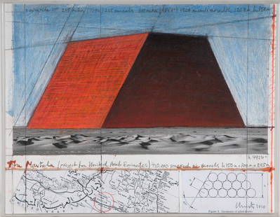
Sold2016CHRISTO & JEANNE-CLAUDE: "ABU DHABI MASTABA""ABU DHABI MASTABA (PROJECT FOR UNITED ARAB EMIRATES)"circa 2010 pencil, charcoal, oil stick, collaged aerial map and photograph on board signed and dated verso Provenance: The Estate of David Copley,See Sold Price
Sold2022ORTELIUS, ABRAHAM. Typus Orbis Terrarum.ORTELIUS, ABRAHAM. Typus Orbis Terrarum. Double-page engraved map of the world. 16¾x20½ inches sheet size, wide margins, Dutch text on verso; original hand-color; professionally conserved wiSee Sold Price
Sold2022ORTELIUS, ABRAHAM. Americae Sive Novi Orbis, Nova Descriptio.ORTELIUS, ABRAHAM. Americae Sive Novi Orbis, Nova Descriptio. Double-page engraved map of the Western Hemisphere. 17½x22¼ inches sheet size, wide margins, Spanish text on verso; uncolored; cSee Sold Price
Sold2017Mercator (Gerard) - Atlas sive Cosmographicae,Editio Quinta, engraved pictorial title, prelims, 49 double-page maps, including Asia, Russia, Turkey, Lithuania, Asia Minor and Persia, regions of Italy Spain, Germany and Eastern Europe, and 11 singSee Sold Price
Sold2018Jean Prouve, Standard chairs, pairJean Prouve Standard chairs, pair VitraFrance / Germany, 1950 / c. 2010enameled steel, teak plywood, aluminum, rubber16.25 w × 19.5 d × 32.5 h in (41 × 50 × 83 cm)See Sold Price
2 days LeftTrillium Antique Prints & Rare BooksPtolemy & Magini, pub. 1620 - Map of the Americas$50(1 bid)
2 days LeftTrillium Antique Prints & Rare BooksPtolemy & Magini, pub. 1620 - Map of the World$50(1 bid)
2 days LeftTrillium Antique Prints & Rare BooksPtolemy & Magini, pub. 1620 - Map of the Ancient World with Africa, Europe, Asia$50
2 days LeftTrillium Antique Prints & Rare BooksPtolemy & Magini, pub. 1620 - Map of Taprobana, Island in Sumatra$50
2 days LeftTrillium Antique Prints & Rare BooksBraun & Hogenberg, pub. 1575 - View of Innsbruck, Germany$100(1 bid)
2 days LeftTrillium Antique Prints & Rare BooksBraun & Hogenberg, pub. 1575 - View of Cusco, Peru and Mexico$375(4 bids)
2 days LeftTrillium Antique Prints & Rare BooksBraun & Hogenberg, pub. 1575 - View of Jerusalem, Israel$100(1 bid)
May 09Hunt and Peck Estate Services, Inc.Jacques Nicolas Bellin Map Of Western Part Of New France Or Canada$200(1 bid)
May 14Fleischer's Auctions1755 Map Partie de l'Amerique Septentrionale, qui comprend Le Cours de L'Ohio...$200(3 bids)
2 days LeftBucklinMagdanz, Andreas; Dienststelle Marienthal [2000 1ST EDITION & 1ST PRINTING LIMITED EDITION 1/1500 -$80


![Gallia Color Map [France]: Galliae Regni Potentiss Color Map with written description in Latin on verso. Map of France with boarders to Germany, Spain and Italy. Appears to be a page from an atlas. Undated. Measures 14 in. x 20](https://p1.liveauctioneers.com/5755/154409/77936853_1_x.jpg?height=310&quality=70&version=1573094011)


![Jansson (Jan) - [Atlas Novus: Germany],: single vol. lacking title, 106 mostly regional maps of Germany and northern Europe, but also including a general map of Germany, and classical maps of both Germany and Scandinavia, and several city pl](https://p1.liveauctioneers.com/410/80717/41962763_1_x.jpg?height=310&quality=70&version=1445353131)
![Ptolemy / Waldseemuller Map of Sri Lanka or Taprobana, 1513 or 1520: PTOLEMY, Claudius (2nd Century) & WALDSEEMULLER, Martin (1470-1520). [Sri Lanka or Taprobana] Duodecima Asiae Tabula. Woodcut Map with original hand color. Strasbourg: Schott, 1513 or 1520. 17 1/2" x](https://p1.liveauctioneers.com/1968/250616/130196500_1_x.jpg?height=310&quality=70&version=1654190895)


![Ptolemy. Cosmographia, 1490: Ptolemy (Claudius Ptolemaeus.) COSMOGRAPHIA. [Rome: Petrus de Turre, 1490.] Folio, 428 x 285mm, a2-c8 on shorter leaves measuring 411 x 275mm. Text portion only, lacking all maps. A2-C8, D6, E5, a2-10](https://p1.liveauctioneers.com/3532/95081/48483405_1_x.jpg?height=310&quality=70&version=1476656219)