Sold2018Mitchell: Antique Map of Utah and Nevada,1870Title/Content of Map: 1870 Mitchell Map of Utah and Nevada -- County Map of Utah and Nevada Date Printed: 1870 Philadelphia Cartographer: S Mitchell Size: 10.6 X 13.5 in. Handsome county map of Utah aSee Sold Price
Sold2017Mitchell: Antique County Map of Utah & Nevada, 1870[Utah, Nevada]. N. p: S. Augustus Mitchell, 1870s. The map was drawn and engraved by W. H. Gamble of Philadelphia. Coloured map. Approximately 11-3/4 x 14-/4 inches image area, one sheet, matted. FineSee Sold Price
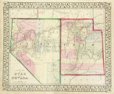
Sold2019Mitchell: County Map of Utah & NevadaMap Title: County Map of Utah and NevadaCartographer: S. A. Mitchell Place/Date: Philadelphia / 1870 Size: 14" x 11 5/8" Condition: full color; light overall age toning The beautifully detailed and coSee Sold Price
Sold2022Nevada & Utah 1880Title/Content of Map: Nevada & Utah 1880 Date Printed: 1880 Material/Medium: paper Size: folio, 23x 15 inches Additional Info: Hand colored county & township map of Utah & Nevada by Mitchell. Map measSee Sold Price
Sold20231877 Mitchell Map of Utah and Nevada [verso] Arizona and New Mexico -- County Map of of Utah andTitle: 1877 Mitchell Map of Utah and Nevada [verso] Arizona and New Mexico -- County Map of of Utah and Nevada [verso] County Map Arizona and New Mexico Cartographer: S Mitchell Year / Place: 1877 PhiSee Sold Price
Sold20191876 Mitchell Map of Utah and Nevada [verso] ArizonaTitle/Content of Map: 1876 Mitchell Map of Utah and Nevada [verso] Arizona and New Mexico -- County Map of of Utah and Nevada [verso] County Map Arizona and New Mexico Date: 1876 Philadelphia CartograSee Sold Price
Sold20181870 Mitchell Map of Minnesota -- County Map ofTitle/Content of Map: 1870 Mitchell Map of Minnesota -- County Map of Minnesota Date: 1870, Philadelphia Cartographer: S Mitchell Size: 13.8 x 11.5 in. This is nice county map of Minnesota. Great dealSee Sold Price
Sold20221870 Mitchell Map of Pennsylvania -- County Map of theTitle: 1870 Mitchell Map of Pennsylvania -- County Map of the State of Pennsylvania Cartographer: S Mitchell Year/Place: 1870, Philadelphia Dimensions: 11.5 X 14 in. Description: This is a handsome maSee Sold Price
Sold2018Mitchell: Antique Map of Pennsylvania, 1870Title/Content of Map: 1870 Mitchell Map of Pennsylvania -- County Map of the State of Pennsylvania Date Printed: 1870, Philadelphia Cartographer: S Mitchell Size: 14 X 21.5 in. A very nice large, pastSee Sold Price
Sold20211870 Mitchell Map of New York -- County Map of theTitle: 1870 Mitchell Map of New York -- County Map of the State of New York Cartographer: S Mitchell Year / Place: 1870, Philadelphia Map Dimension (in.): 13.7 X 21 in. This is an excellent map of theSee Sold Price
Sold20241870 Mitchell Map of Ohio and Indiana -- County Map of Ohio and IndianaTitle: 1870 Mitchell Map of Ohio and Indiana -- County Map of Ohio and Indiana Cartographer: S Mitchell Year / Place: 1870 Philadelphia Map Dimension (in.): 11.5 X 13.8 in. This is a very nice map ofSee Sold Price
Sold20181870 Mitchell Map of Virginia and West Virginia --Title/Content of Map: 1870 Mitchell Map of Virginia and West Virginia -- County Map of Virginia and West Virginia Date: 1870, Philadelphia Cartographer: S Mitchell Size: 11.9 x 14.6 in. This handsomeSee Sold Price
Sold2018Mitchell: County Map of Kentucky & Tennessee, 1870Title/Content of Map: County Map of Kentucky and Tennessee Cartographer: S. A. Mitchell Place & Date: Philadelphia / 1870 Size: 13 3/8" x 9 3/4" Condition: full color; light overall age toning; slightSee Sold Price
Sold2018Mitchell: Antique County Map Illinois/Springfield, 1870Map: County Map of the State of Illinois Cartographer: S. A. Mitchell Place & Date: Philadelphia / 1870 Size: 10 3/4" x 13 5/8" Condition: full color; light overall age toning The beautifully detailedSee Sold Price
Sold2017Mitchell: Antique County Map of Texas, 1870Map: County Map of Texas Cartographer: S. A. Mitchell Place & Date: Philadelphia / 1870 Size: 13 1/4" x 10 3/4" Condition: full color; light overall age toning The beautifully detailed and colored couSee Sold Price
Sold2018Mitchell: Antique County Map of Florida, 1870County Map of Florida The beautifully detailed and colored county map of Florida from the 1870 edition of Mitchell's popular New General Atlas of the world. Framed by the vine motif border typical ofSee Sold Price
Sold2018Mitchell: Antique County Map of Maine, 1870County Map of the State of Maine The beautifully detailed and colored county map of Maine from the 1870 edition of Mitchell's popular New General Atlas of the world. Framed by the vine motif border tySee Sold Price
Sold2018Mitchell: County Map of PennsylvaniaReserve Reduced! The beautifully detailed and colored county map of Pennsylvania from the 1870 edition of Mitchell's popular New General Atlas of the world. The map is framed by the vine motif borderSee Sold Price
Sold2017Mitchell: Antique Map of New Jersey Delaware MarylandTitle/Content of Map: 1870 Mitchell: New Jersey, Delaware and Maryland -- County Map of Maryland and Delaware [on Sheet with] County Map of New Jersey Date Printed: 1870, Philadelphia Cartographer: SSee Sold Price
Sold20231881 Map of Utah & Nevada by Mitchell1881 Map of Utah & Nevada by Mitchell. Overall size 22 1/2"h x 29 1/2"wSee Sold Price
Sold2019Mitchell: 1870s Map of Georgia and AlabamaReserve Reduced! The beautifully detailed and colored county map of the states of Georgia and Alabama from the 1870 edition of Mitchell's popular New General Atlas of the world. The map is framed by tSee Sold Price
Sold2018Mitchell: Antique Map of New York State w/ city insetsCounty Map of the State of New York The beautifully detailed and colored county map of New York State from the 1870 edition of Mitchell's popular New General Atlas of the world. Framed by the vine motSee Sold Price
Sold2018Mitchell: MinnesotaReserve Reduced! The beautifully detailed and colored county map of Minnesota from the 1870 edition of Mitchell's popular New General Atlas of the world. Framed by the decorative vine motif border typSee Sold Price
Sold2019Two Copies of Samuel Augustus Mitchell (1790-1868), "Two Copies of Samuel Augustus Mitchell (1790-1868), " County Map of Arkansas, Mississippi, and Louisiana," 1870, hand colored, H.-15 1/8 in., W.- 23 1/8 in. (2 Pcs.)See Sold Price
3 days LeftJasper521860 Mitchell Map of Kentucky and Tennessee -- County Map of Kentucky and Tennessee$40
Jun 07Freeman's | Hindman[HARDY, Thomas] -- HUTCHINS, John. The History and Antiquities of the County of Dorset by John$250
3 days LeftJasper521865 Johnson Map of Arkansas, Mississippi and Louisiana -- Johnson's Arkansas, Mississippi and$60
Featured3 days LeftJasper52Mitchell’s Map of Asia showing travel routes London, India, China & Japan, 1860$45
4 days LeftPotter & Potter AuctionsMcCARTY, Lea (1905 – 1960). Sonoma County / Its Highlights ...$100(1 bid)
3 days LeftJasper521869 Mitchell Map of South-Central Europe [verso] Asia -- XXXIV Austria, Switzerland, Italy, Turkey$30
3 days LeftJasper521861 Mitchell Map of Washington DC -- Plan of the City of Washington The Capitol of the United$70
3 days LeftJasper521869 Mitchell Map of Much of Western Europe -- XXXII Prussia the German States Holland & Belgium$30
3 days LeftJasper521858 Mitchell Map of Great Britain and Ireland [verso] Germany and Switzerland -- No. 22 Map of$25
3 days LeftJasper521858 Mitchell Map of Southern Europe and France [verso] Asia -- No. 24 Map of France, Spain,$30
May 22Thomaston Place Auction GalleriesEARLY 17TH C. ELIZABETHAN ENGRAVED MAP OF CORNWALL BY WILLIAM KIP AFTER WILLIAM SAXTON$150
5 days LeftAlbion AuctionsGentleman's Magazine 1778 Canal Map. Basingstoke, River Wey, Surrey$5(1 bid)
4 days LeftPotter & Potter AuctionsLINDGREN, Hjalmer “Jolly” (1895–1952). A Hysterical Map of ...$150(1 bid)


![Mitchell: Antique County Map of Utah & Nevada, 1870: [Utah, Nevada]. N. p: S. Augustus Mitchell, 1870s. The map was drawn and engraved by W. H. Gamble of Philadelphia. Coloured map. Approximately 11-3/4 x 14-/4 inches image area, one sheet, matted. Fine](https://p1.liveauctioneers.com/5584/107399/55057774_1_x.jpg?height=310&quality=70&version=1501794677)

![1877 Mitchell Map of Utah and Nevada [verso] Arizona and New Mexico -- County Map of of Utah and: Title: 1877 Mitchell Map of Utah and Nevada [verso] Arizona and New Mexico -- County Map of of Utah and Nevada [verso] County Map Arizona and New Mexico Cartographer: S Mitchell Year / Place: 1877 Phi](https://p1.liveauctioneers.com/5584/293457/155766077_1_x.jpg?height=310&quality=70&version=1687903812)
![1876 Mitchell Map of Utah and Nevada [verso] Arizona: Title/Content of Map: 1876 Mitchell Map of Utah and Nevada [verso] Arizona and New Mexico -- County Map of of Utah and Nevada [verso] County Map Arizona and New Mexico Date: 1876 Philadelphia Cartogra](https://p1.liveauctioneers.com/5584/137769/69881187_1_x.jpg?height=310&quality=70&version=1552435690)


![Mitchell: Antique Map of New Jersey Delaware Maryland: Title/Content of Map: 1870 Mitchell: New Jersey, Delaware and Maryland -- County Map of Maryland and Delaware [on Sheet with] County Map of New Jersey Date Printed: 1870, Philadelphia Cartographer: S](https://p1.liveauctioneers.com/5584/111364/57183768_1_x.jpg?height=310&quality=70&version=1509054701)


![[HARDY, Thomas] -- HUTCHINS, John. The History and Antiquities of the County of Dorset by John (1 of 2)](https://p1.liveauctioneers.com/197/329395/177650388_1_x.jpg?height=282&quality=70&version=1715364962)


![1869 Mitchell Map of South-Central Europe [verso] Asia -- XXXIV Austria, Switzerland, Italy, Turkey (1 of 2)](https://p1.liveauctioneers.com/5584/328338/176911683_1_x.jpg?height=282&quality=70&version=1715113718)


![1858 Mitchell Map of Great Britain and Ireland [verso] Germany and Switzerland -- No. 22 Map of (1 of 2)](https://p1.liveauctioneers.com/5584/328338/176911589_1_x.jpg?height=282&quality=70&version=1715113718)
![1858 Mitchell Map of Southern Europe and France [verso] Asia -- No. 24 Map of France, Spain, (1 of 2)](https://p1.liveauctioneers.com/5584/328338/176911601_1_x.jpg?height=282&quality=70&version=1715113718)


