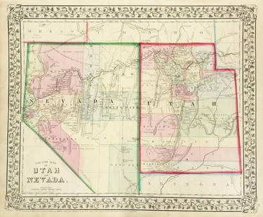
Sold2017Mitchell: Antique County Map of Utah & Nevada, 1870[Utah, Nevada]. N. p: S. Augustus Mitchell, 1870s. The map was drawn and engraved by W. H. Gamble of Philadelphia. Coloured map. Approximately 11-3/4 x 14-/4 inches image area, one sheet, matted. FineSee Sold Price
Sold2018Mitchell: Antique Map of Utah and Nevada,1870Title/Content of Map: 1870 Mitchell Map of Utah and Nevada -- County Map of Utah and Nevada Date Printed: 1870 Philadelphia Cartographer: S Mitchell Size: 10.6 X 13.5 in. Handsome county map of Utah aSee Sold Price
Sold2018Mitchell: Antique County Map Illinois/Springfield, 1870Map: County Map of the State of Illinois Cartographer: S. A. Mitchell Place & Date: Philadelphia / 1870 Size: 10 3/4" x 13 5/8" Condition: full color; light overall age toning The beautifully detailedSee Sold Price
Sold2019Mitchell: County Map of Utah & NevadaMap Title: County Map of Utah and NevadaCartographer: S. A. Mitchell Place/Date: Philadelphia / 1870 Size: 14" x 11 5/8" Condition: full color; light overall age toning The beautifully detailed and coSee Sold Price
Sold2017Mitchell: Antique County Map of Texas, 1870Map: County Map of Texas Cartographer: S. A. Mitchell Place & Date: Philadelphia / 1870 Size: 13 1/4" x 10 3/4" Condition: full color; light overall age toning The beautifully detailed and colored couSee Sold Price
Sold2018Mitchell: Antique County Map of Florida, 1870County Map of Florida The beautifully detailed and colored county map of Florida from the 1870 edition of Mitchell's popular New General Atlas of the world. Framed by the vine motif border typical ofSee Sold Price
Sold2018Mitchell: Antique County Map of Maine, 1870County Map of the State of Maine The beautifully detailed and colored county map of Maine from the 1870 edition of Mitchell's popular New General Atlas of the world. Framed by the vine motif border tySee Sold Price
Sold2022Nevada & Utah 1880Title/Content of Map: Nevada & Utah 1880 Date Printed: 1880 Material/Medium: paper Size: folio, 23x 15 inches Additional Info: Hand colored county & township map of Utah & Nevada by Mitchell. Map measSee Sold Price
Sold20231877 Mitchell Map of Utah and Nevada [verso] Arizona and New Mexico -- County Map of of Utah andTitle: 1877 Mitchell Map of Utah and Nevada [verso] Arizona and New Mexico -- County Map of of Utah and Nevada [verso] County Map Arizona and New Mexico Cartographer: S Mitchell Year / Place: 1877 PhiSee Sold Price
Sold20191876 Mitchell Map of Utah and Nevada [verso] ArizonaTitle/Content of Map: 1876 Mitchell Map of Utah and Nevada [verso] Arizona and New Mexico -- County Map of of Utah and Nevada [verso] County Map Arizona and New Mexico Date: 1876 Philadelphia CartograSee Sold Price
Sold2017Mitchell: Antique Map of New Jersey Delaware MarylandTitle/Content of Map: 1870 Mitchell: New Jersey, Delaware and Maryland -- County Map of Maryland and Delaware [on Sheet with] County Map of New Jersey Date Printed: 1870, Philadelphia Cartographer: SSee Sold Price
Sold2018Mitchell: Antique Map of Pennsylvania, 1870Title/Content of Map: 1870 Mitchell Map of Pennsylvania -- County Map of the State of Pennsylvania Date Printed: 1870, Philadelphia Cartographer: S Mitchell Size: 14 X 21.5 in. A very nice large, pastSee Sold Price
Sold2018Mitchell: Antique Map of New York State w/ city insetsCounty Map of the State of New York The beautifully detailed and colored county map of New York State from the 1870 edition of Mitchell's popular New General Atlas of the world. Framed by the vine motSee Sold Price
Sold2019California Southwest Antique MapEarly map: California, also Utah, Nevada, Colorado, New Mexico and Arizona. Map by A.J. Johnson, New York, c. 1870. 18" x 26 1/2".See Sold Price
Sold2018Mitchell: Antique Map of England and Wales, 1870Title/Content of Map: County Map of England, and Wales Cartographer: S. A. Mitchell Place & Date: Philadelphia / 1870 Size: 10 5/8" x 13 1/2" Condition: full color; light overall age toning The beautiSee Sold Price
Sold2018Mitchell: Antique Map of Michigan & Wisconsin, 1870Title/Content of Map: County Map of Michigan and Wisconsin Cartographer: S. A. Mitchell Place & Date: Philadelphia / 1870 Size: 13 3/4" x 11 78" Condition: full color; light overall age toning The beaSee Sold Price
Sold2017Mitchell: Antique County Map of Texas, 1873Excellent 1873 County Map of Texas by S. Augustus Mitchell. Impressive two-page County Map of the State of Texas. Map image much larger than earlier Mitchell maps. Designed and engraved by W. H. GamblSee Sold Price
Sold2017Mitchell: Antique Map of Cincinnati, 1870Map: 1870 Mitchell Map of Cincinnati -- Plan of Cincinnati and Vicinity Cartographer: S. A. Mitchell Year / Place: 1870, Philadelphia Map Dimensions: 10.5 x 11 in. Condition: Very good; Good colors. SSee Sold Price
Sold2018Mitchell: Antique Map of Philadelphia, 1870Title/Content of Map: 1870 Mitchell Map of Philadelphia -- Plan of Philadelphia Date Printed: 1870, Philadelphia Cartographer: S Mitchell Size: 11 X 12.8 in. A very nice map of the City of Brotherly LSee Sold Price
Sold2017Mitchell: Antique Map of Baltimore, 1870Map: 1870 Mitchell Map of Baltimore -- Plan of Baltimore Cartographer: S Mitchell Year / Place: 1870, Philadelphia Map Dimensions: 9 X 11.2 in. Condition: Very good; Pastel colors. Some age toning, moSee Sold Price
Sold2017Mitchell: Antique Political Map of Asia, 1870Map: Map of Asia Showing its Gt. Political Divisions, and also the various Routes of Travel between London & India, China & Japan &c Cartographer: S. A. Mitchell Place & Date: Philadelphia / 1870 SizeSee Sold Price
Sold2018Mitchell: County Map of Kentucky & Tennessee, 1870Title/Content of Map: County Map of Kentucky and Tennessee Cartographer: S. A. Mitchell Place & Date: Philadelphia / 1870 Size: 13 3/8" x 9 3/4" Condition: full color; light overall age toning; slightSee Sold Price
20181870 Mitchell Antique Map of Venezuela, ColumbiaTitle/Content of Map: 1870 Mitchell Map of Venezuela, Columbia, Granada, Peru, Equador and part of Argentina -- Map of New Granada, Venezuela, Guiana, Peru, Equador and Argentine Confederation Date PrSee Sold Price
Sold2017Mitchell: Antique Map of Oregon Washington Idaho, 1870Map: Map of Oregon, Washington, Idaho, and Part of Montana Cartographer: S. A. Mitchell Place & Date: Philadelphia / 1870 Size: 13 3/8" x 10 7/8" Condition: full color; light overall age toning; someSee Sold Price
Jun 23Treasure Quest AuctionsHamilton Child's Business Directory for Albany & Schenectady County 1870-71$50
Jun 23Treasure Quest AuctionsGreene County, NY Directory for 1896 by Fred Craigie, Catskill NY with Map$50
Jun 23Treasure Quest AuctionsPr. Child's Ulster County, NY 1871-72 Gazetteer & Business Directories$50
3 days LeftJasper52JAMAICA. Counties/parishes. Sugar Mill & Kingston views. RAPKIN/TALLIS 1851 map$85


![Mitchell: Antique County Map of Utah & Nevada, 1870: [Utah, Nevada]. N. p: S. Augustus Mitchell, 1870s. The map was drawn and engraved by W. H. Gamble of Philadelphia. Coloured map. Approximately 11-3/4 x 14-/4 inches image area, one sheet, matted. Fine](https://p1.liveauctioneers.com/5584/107399/55057774_1_x.jpg?height=310&quality=70&version=1501794677)


![1877 Mitchell Map of Utah and Nevada [verso] Arizona and New Mexico -- County Map of of Utah and: Title: 1877 Mitchell Map of Utah and Nevada [verso] Arizona and New Mexico -- County Map of of Utah and Nevada [verso] County Map Arizona and New Mexico Cartographer: S Mitchell Year / Place: 1877 Phi](https://p1.liveauctioneers.com/5584/293457/155766077_1_x.jpg?height=310&quality=70&version=1687903812)
![1876 Mitchell Map of Utah and Nevada [verso] Arizona: Title/Content of Map: 1876 Mitchell Map of Utah and Nevada [verso] Arizona and New Mexico -- County Map of of Utah and Nevada [verso] County Map Arizona and New Mexico Date: 1876 Philadelphia Cartogra](https://p1.liveauctioneers.com/5584/137769/69881187_1_x.jpg?height=310&quality=70&version=1552435690)
![Mitchell: Antique Map of New Jersey Delaware Maryland: Title/Content of Map: 1870 Mitchell: New Jersey, Delaware and Maryland -- County Map of Maryland and Delaware [on Sheet with] County Map of New Jersey Date Printed: 1870, Philadelphia Cartographer: S](https://p1.liveauctioneers.com/5584/111364/57183768_1_x.jpg?height=310&quality=70&version=1509054701)


