Sold2016Antique Map, A New Map of the County of CornwallC. Smith (British, 19th century), "A New Map of the County of Cornwall Divided into Hundreds," 1804, hand-colored copper engraved map, published in Smith's New English Atlas, with the Jones & Smith scSee Sold Price
Sold20201808 Smith Map of Cambridge UK -- A New Map of theTitle: 1808 Smith Map of Cambridge UK -- A New Map of the County of Cambridge Divided into Hundreds Date: 1808, London Cartographer: C Smith Size: 19.5 x 17.4 in. Additional Information: This is a verSee Sold Price
Sold2022Ireland.- Moll (Herman) A New Map of Ireland Divided into its Provinces, Counties and Baronies...,Ireland.- Moll (Herman) A New Map of Ireland Divided into its Provinces, Counties and Baronies..., large map of Ireland with inset plans of Dublin, Cork, Kinsale, Limerick, Waterford and Galway, and oSee Sold Price
Sold2022Oxford & Eastern counties.- Kitchin (Thomas) A newNO RESERVE Oxford & Eastern counties.- Kitchin (Thomas) A new Improved Map of Oxfordshire from the best surveys and intelligences, divided into hundreds, county map with decorative title cartouche inSee Sold Price
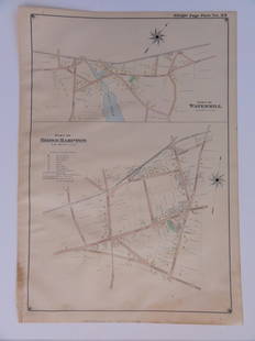
Sold2016Bridgehampton & Watermill, Long Island, 1902Original engraving published by E. Belcher Hyde from "Atlas of Suffolk County, Long Island, New York," Philadelphia, 1902. Map features family names, historic buildings and railroad routes. DimensionsSee Sold Price
Sold2016Town of Southampton Map (North Haven & Art Village),Original engraving of Southhampton town, including Peconic Bay, Hobson Island and many landmarks & family names. Published by E. Belcher Hyde from "Atlas of Suffolk County, Long Island, New York," 190See Sold Price
Sold2023E. Belcher Hyde Map Co. - Maps of Suffolk, Group of 4Lot 49 E. Belcher Hyde Map Co. American Manufacturer (fl. c. 1880 - 1920) Maps of Suffolk, Group of 4 (1916) lithograph with hand coloring from Suffolk County 1916 Vol 2 Long Island, New York, includeSee Sold Price
Sold2023E. Belcher Hyde Map Co. - Maps of Sag Harbor, Group of 2Lot 48 E. Belcher Hyde Map Co. American Manufacturer (fl. c. 1880 - 1920) Maps of Sag Harbor, Group of 2 (1916) lithograph with hand coloring from Suffolk County 1916 Vol 2 Long Island, New York 17 xSee Sold Price
Sold2022SUFFOLK COUNTY NEW YORK POLICE BADGE NO. 1058SUFFOLK COUNTY NEW YORK POLICE BADGE NO. 1058 Obsolete Suffolk County, New York Police badge. Numbered 1058. Unmarked. Measurements: 2.75 x 2.25"See Sold Price
Sold2022SUFFOLK COUNTY NEW YORK POLICE DETECTIVE BADGE NO. 110SUFFOLK COUNTY NEW YORK POLICE DETECTIVE BADGE NO. 110 Obsolete Suffolk County, New York Police Department Detective badge. Number 110. Unmarked. Measurements: 2 x 2.25"See Sold Price
Sold2024Map of the US, Colton, 1874 [179353]The New County map of the United States of America,[x=#8221/] drawn, engraved and printed by G. W. and C. B. Colton & Co., New York 1874. Very large multicolor map, linen back in original Colton bindiSee Sold Price
Sold20171855 Barnes's Map of Pennsylvania. A new county m1855 Barnes's Map of Pennsylvania. A new county map of Pennsylvania and adjoining states. Showing Central and other railroads.-- Dimensions: H: 26 inches: W: 37.5 inches ---See Sold Price
Sold20211794 Anville Map of the Arabian Peninsula and Red SeaTitle: 1794 Anville Map of the Arabian Peninsula and Red Sea -- A New Map of Arabia Divided into its Several Regions and Districts from Mons. D'Anville… Cartographer: J d'Anville / Larie and WhittleSee Sold Price
Sold2022London.- Bacon (George W.) Bacon's New Map of LondonLondon.- Bacon (George W.) Bacon's New Map of London divided into half mile squares and circles, lithograph with some hand-colouring, sheet 680 x 990 mm (26 3/4 x 39 in), mounted on linen, folding intSee Sold Price
Sold2016Holy Roman Empire 1805Map Title: The Holy Roman Empire in its Final Year Germany/ Poland/ Czech Republic/ Austria/ Netherlands (A New Map Of Germany Divided Into Its Circles). Published: Laurie & Whittle, London Date: 1805See Sold Price
Sold2023Early 19th Century Map Engravings of Europe by William Darton (1755-1819)New Map of Europe & A New Map of France Divided into its Departments 2 engravings on paper William Darton (1755-1819) 11.75 x 9.5 (plate) 15.5 x 12.25 inches (paper) (unframed) William Darton (175See Sold Price
Sold2022SUFFOLK CO NY POLICE DETECTIVE SERGEANT BADGE NO. 576SUFFOLK CO NY POLICE DETECTIVE SERGEANT BADGE NO. 576 Obsolete Suffolk County, New York Police Department Detective Sergeant badge. Numbered 576. Unmarked. Measurements: 1.5 x 1.5"See Sold Price
Sold20211902 Tennessee MapTitle: 1902 Tennessee Map Author: Century Medium: Ink on Paper Dimensions: 11.5"X16" Description: Map of Tennessee dated 1902. Printed and published by The Century Co. in New York. Dual map divided inSee Sold Price
Sold2018UK - Staffordshire 1808 Hand Col Map by Charles Smith"A New Map of the County of Stafford" Copper Engraved Map Published 1808, London. Printed for C. Smith. Dissected and linen backed. Original hand colour. Paper Size: 20.5 x 19 inch (52 x 48cm) Good coSee Sold Price
Sold2020Railroad and County Map of New Mexico.Title/Content of Map: Railroad and County Map of New Mexico. Date: 1888 Cartographer: CRAM, GEORGE F. Publisher: GEO. F. CRAM Size: 22.25Height - 16.25Width Detailed state map with railroads named butSee Sold Price
Sold2023An 1860 Map, Counties of New York, New Hampshire, Etc...Hand colored lithograph, by Samuel Augustus Mitchell (1790-1868). :County Map of the States of New York, New Hampshire, Vermont, Massachusetts, Rhode Island and Connecticut". Dimensions:15 1/2" x 23 1See Sold Price
Sold20231877 Mitchell Map of Utah and Nevada [verso] Arizona and New Mexico -- County Map of of Utah andTitle: 1877 Mitchell Map of Utah and Nevada [verso] Arizona and New Mexico -- County Map of of Utah and Nevada [verso] County Map Arizona and New Mexico Cartographer: S Mitchell Year / Place: 1877 PhiSee Sold Price
Sold20231890s Map of Vermont and New Hampshire -- County Map of Vermont and New HampshireTitle: 1890s Map of Vermont and New Hampshire -- County Map of Vermont and New Hampshire Cartographer: Anonymous Year / Place: 1890 ca. Map Dimension (in.): 21.6 X 14.8 in. This is an outstanding doubSee Sold Price
4 days LeftJasper52New Map of That Portion of North America Exhibiting the United States and Territories...Mexico...$360
May 09Hunt and Peck Estate Services, Inc.1794 Laurie & Whittle after Thomas Jefferys Map Of The United States Of America$340(1 bid)
13 hrs LeftMatthew Bullock AuctioneersWilliam Tecumseh Sherman, Union Commanding General of the Army, XV Corps$700
2024Rapid Estate Liquidators and Auction GalleryThe Newsday Magazine 1982 Marilyn Monroe AnniversarySee Sold Price
2 days LeftClaydon Auctioneers LtdMap: An 18thC map of Gloucestershire with hand colouring, titled An Accurate Map of the Counties of£40
May 12Schilb Antiquarian Rare Books1881 Westchester County New York Yonkers Illustrated MAPS 2v SET Bolton History$16(2 bids)


![Map of the US, Colton, 1874 [179353]: The New County map of the United States of America,[x=#8221/] drawn, engraved and printed by G. W. and C. B. Colton & Co., New York 1874. Very large multicolor map, linen back in original Colton bindi](https://p1.liveauctioneers.com/2699/324080/174413237_1_x.jpg?height=310&quality=70&version=1711759488)


![1877 Mitchell Map of Utah and Nevada [verso] Arizona and New Mexico -- County Map of of Utah and: Title: 1877 Mitchell Map of Utah and Nevada [verso] Arizona and New Mexico -- County Map of of Utah and Nevada [verso] County Map Arizona and New Mexico Cartographer: S Mitchell Year / Place: 1877 Phi](https://p1.liveauctioneers.com/5584/293457/155766077_1_x.jpg?height=310&quality=70&version=1687903812)


