Sold20191919 Rhine River Birds Eye View for Occupying US ForcesTitle/Content of Map: 1919 Rhine River Birds Eye View for Occupying US Forces -- Rhine Panorama for the Men of the American Army of OccupationÂ… Date: 1919 Cartographer: YMCA sponsored Size: 62.6 XSee Sold Price
Sold2018A NEW MAP OF THE RIVER MISSISSIPI FROM THE SEA"A NEW MAP OF THE RIVER MISSISSIPI FROM THE SEA". Height: 12 & 7 in. by Width: 14 & 9 in.See Sold Price
Sold2019Guillaume De L’isle (1675-1726), "The Seat of War onGuillaume De L’isle (1675-1726), "The Seat of War on the Rhine a new Map of the Course of the River from Basil to Bonn," 1710, H. - 53 in., W. - 25 in.See Sold Price
Sold2017Antique Map of Louisiana and Mississipi River, 1761Title/Content of Map: A New Map of Louisiana and the River Mississipi from the Sea to Bayagoulas Date Printed: 1761 Cartographer: London Magazine Size (inches): 9 x 7 Detailed antique map of the MissiSee Sold Price
Sold2022Clean 1874 Plan of New Orleans by S. Augustus MitchellVery attractive and authentic antique map of New Orleans, published in 1874 by S. Augustus Mitchell. Shows railroad lines, streets, buildings, rivers, towns and more. A beautiful city plan from one ofSee Sold Price
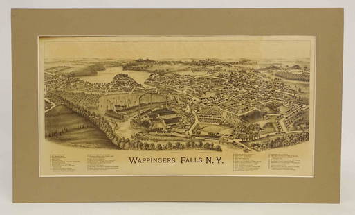
Sold2022Wappingers Falls New York Large ViewWappingers Falls, N.Y. Large Panorama Bird's-eye Map. L.R. Burleigh, Troy, New York, c. 1889. Antique print. 15" x 29".See Sold Price
Sold2023Antique Lot 9 Guides and Scenic View Souvenir Books of Saratoga Springs, New YorkThis is an antique lot of nine guidebooks and souvenir books from Saratoga Springs, New York. One of the guidebooks contains a long fold out map of the length of the Hudson River and another offers aSee Sold Price
Sold2023MAPS CARTOGRAPHY ITEMS WITH 2 HAND DRAWINGSThe lot includes a framed mid century American map Penobscot Bay And Approaches, United States - East Coast - Maine, Scale 1:80 000; Raritan River From Raritan Bay to New Brunswick New Jersey, Scale 2See Sold Price
Sold2022MAPS CARTOGRAPHY ITEMS WITH 2 HAND DRAWN PIECESThe lot includes a framed mid century American map Penobscot Bay And Approaches, United States - East Coast - Maine, Scale 1:80 000; Raritan River From Raritan Bay to New Brunswick New Jersey, Scale 2See Sold Price
Sold2018Weller: Antique Map of Empire of Japan, 1863TITLE/CONTENT OF MAP: 'The Empire of Japan with part of the Continent of Asia showing The River Amoor and the New Boundary between The Russian & Chinese Territories' The map shows the Island of SakhalSee Sold Price
Sold2022Kelly, Christopher 1836 Antique Print. Bridge of the River Nisa, SpainCopper Plate Published 1836, London for "A New and Complete System of Universal Geography" by Christopher Kelly. Maps Engraved by Findlay, Wallis and others. Paper Size: 10.5 x 8 inch (27 x 20cm) GoodSee Sold Price
Sold20211640 Jansson Map of Rhine River Area in Netherlands andTitle: 1640 Jansson Map of Rhine River Area in Netherlands and Germany in Part -- Descriptio Fluminum Rheni, Vahalis et Mosae Cartographer: J Jansson Year / Place: c 1640, Amsterdam Map Dimension (in.See Sold Price
Sold2017Rand McNally: Antique World Map, Rivers & MountainsMap: Rand McNally World Map and Comperative Chart of Rivers and Mountains -- The World on Mercator's Projection [verso] Western Hemisphere Cartographer: Rand McNally Year / Place: 1898, Chicago Map DiSee Sold Price
Sold2017Antique Map: New York & Area - EngravingPensylvania Nova Jersey et Nova York cum Regionibus Ad Fluvium Delaware In America Sitis, Nova Delinatione ob oculos posita...Tobias Conrad Lotter (1717 - 1777). Engraved map with hand-color in part.See Sold Price
Sold2017Antique German Panorama: Elbe RiverAntique German lithographic panorama; titled "A Panorama of the Right Bank of the Elbe from Hamburg to Blankenese"; comprised of 18 continuous panels, folded in concertina form; the illustratiSee Sold Price
Sold2020AN ANTIQUE MAP, "New Railroad Map of the United States,AN ANTIQUE MAP, "New Railroad Map of the United States, the Dominion of Canada, Mexico and the West Indies," CHICAGO, CIRCA 1875, hand-colored lithograph on paper, publishing, engraving, and printingSee Sold Price
Sold2022Antique NEW YORK CITY MAP - FramedAntique New York City Map. 28” x 16” New York City map, circa 1860, hand-colored, double matted and framed to 38 ½” x 26”.See Sold Price
Sold2016Antique Map, A New Map of the County of CornwallC. Smith (British, 19th century), "A New Map of the County of Cornwall Divided into Hundreds," 1804, hand-colored copper engraved map, published in Smith's New English Atlas, with the Jones & Smith scSee Sold Price
Sold2017Bellin: Antique Map of Pearl River Delta Islands, 1764Map: Carte des Isles qui sont a l'Entree de la Riviere de Canton Cartographer: Bellin Place & Date: Paris / 1764 Size: 6 3/4" x 8 5/8" Condition: full color; light overall age toning Bellin's wonderfuSee Sold Price
Sold2018Johnson: Antique New York State Map, 1865Title/Content of Map: 1865 Johnson's New York State Map -- Johnson's New York City, Brooklyn, Jersey City, Hoboken, Etc Date Printed: 1865 New York Cartographer: A Johnson & Co. Size: 16.8 x 25 This iSee Sold Price
Sold2016Antique Map : New York, New Jersey - 1870Antique Map : New York, New Jersey, Pennsylvania, Ohio, Delaware, Maryland , Virginia & West Virginia - 1870 Size : 15.5" x 18.5"See Sold Price
Sold2021Antique New York State Map 1903 Color Roll Up RR Map1903 Scarborough's New Railroad, Post Office, Township and County Map of New York. Color map, compiled from the latest government and state surveys and original sources of the era. Insets: Map of NewSee Sold Price
Sold2018Mallet: Antique Map of Alsace / Rhine Valley, 1683Title of the Map: 'Cercle d'Alsace ou du Haut-Rhin' ALSACE/RHINE VALLEY Strasbourg Basel Frankfurt Date Printed: 1683 Image Size: Approx Overall page size 13 x 21cm approximately (5 x 8 inches); imageSee Sold Price
Sold2021Lot Antique Maps New York New JerseyLot of Antique Maps Of New York, New Jersey & Massachusetts. Includes 11 maps from 19th century. Largest map measures 20 inches in height by 23 inches in width. This sale is online only - no public prSee Sold Price
4 days LeftTrillium Antique Prints & Rare BooksAudubon - Severn River and Rocky Mountain Flying Squirrel. 143$25
Featured1 day LeftJasper52General Map of the West Indies'. West sheet only. Bryan EDWARDS. Caribbean 1794$700
1 day LeftJasper52Amér. Mér. Guyane Anglaise #4 bis. Guyana Suriname. VANDERMAELEN 1827 old map$35
4 days LeftTrillium Antique Prints & Rare BooksOxley - Map of the New South Wales, Australia (New Holland)$100
2 days LeftSwann Auction Galleries(CIVIL WAR--VIRGINIA.) Robert B. Hathaway. Letter with detailed map of the possible river crossings$600
6 hrs LeftJasper521874 Holmes Plan of New York's Upper East Side -- Map of the Common Lands from 76th to 93rd Street$750


![Rand McNally: Antique World Map, Rivers & Mountains: Map: Rand McNally World Map and Comperative Chart of Rivers and Mountains -- The World on Mercator's Projection [verso] Western Hemisphere Cartographer: Rand McNally Year / Place: 1898, Chicago Map Di](https://p1.liveauctioneers.com/5584/108569/55677982_1_x.jpg?height=310&quality=70&version=1504123318)


