Sold2019Atlanta / Map of the City of Milwaukee and Bay View,Title: Atlanta / Map of the City of Milwaukee and Bay View, Wis. Publication Date: 1892 Publisher: Rand, McNally & Co. Dimensions: 11.8 X 9.75 Additional Information: Back to back city plans from lateSee Sold Price
Sold2017Currier & Ives: San Francisco Birds Eye View Map, 1878Map: The City of San Francisco Birds Eye View Looking from the Bay South-West Cartographer: Currier & Ives Date: 1878 Size: 11.4 x 17.75 inches This is a rare view of San Francisco of the late 1800s lSee Sold Price
Sold2021POMPEII Antique city town map panorama Domus Pansae BayTITLE/CONTENT OF MAP: 'POMPEII.; inset Domus Pansae; plan of the coast in the vicinity of Vesuvius' The top image on the right hand side shows the entire map. To view a close up of the map showing theSee Sold Price
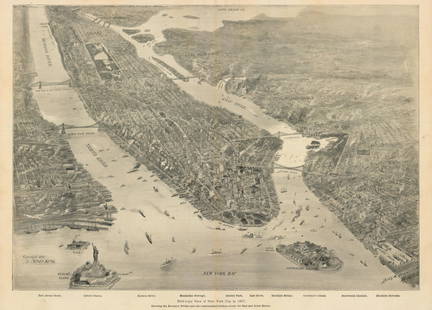
Sold2021New York Bay, 1897Bird’s-Eye View of New York City in 1897This small but intensely detailed map of the city of New York depicts a near snapshot of what could be seen from a rare objective-above. With Burroughs aSee Sold Price
Sold2020Plan de la Baie et de la Ville de PortobeloTITLE/CONTENT OF MAP: 'Plan de la Baie et de la Ville de Portobelo [Plan of the bay and the city of Portobelo]' The top image on the right hand side shows the entire map. To view a close up of the mapSee Sold Price
Sold2023US WALL MAPS AND AERIAL VIEW OF NEW YORK CITYA lot of three antique and vintage wall maps of New York. The lot includes a 1914 map of New York bay and harbor, a D. Lambert Railing Co. color map of New York State, and an aerial view of Hudson RivSee Sold Price
Sold2017Mallet: Antique Map, City View of Cuzco, Peru, 1683Title: 'Cusco' Decorative view of the city of Cuzco, Peru. Date Printed: 1683 Image Size: Approx Overall page size 13 x 21cm approximately (5 x 8 inches); image size 10.5 x 14.5cm approximately (4 x 5See Sold Price
Sold2017Mallet: Antique Map, City View of Jerusalem, 1683Title: 'Ierusalem Moderne' Shows Muslims praying and many mosques. View of the city. Date Printed: 1683 Image Size: Approx Overall page size 13 x 21cm approximately (5 x 8 inches); image size 10.5 x 1See Sold Price
Sold2017Mallet: Antique Map, City View of Amsterdam, 1683Title: 'Amsterdam' Decorative view of the city. Many ships. Netherlands. Date Printed: 1683 Image Size: Approx Overall page size 13 x 21cm approximately (5 x 8 inches); image size 10.5 x 14.5cm approxSee Sold Price
Sold2017George Braun and Frans Hogenberg etchingGeorge Braun (German 1541-1622) and Frans Hogenberg (Flemish 1535-1590)- Map City View - Rome- etching in color, paper loss in upper left and lower left corners, fold down center, minor creases. 15 xSee Sold Price
Sold20212 Paris Map/City Views - Color Prints2 Paris Map/City Views, color printsDimensions: Frames 16 1/4" x 24 1/4" and 19 1/2" x 25 1/4" (VIRO010/2)(WT)See Sold Price
Sold2022TURKISH EMPIRE AND ASIA MINOR SPEED (JOHN) The Turkish Empire, 1676; and 7 other maps of Turkish...TURKISH EMPIRE AND ASIA MINOR SPEED (JOHN) The Turkish Empire, double-page engraved map, 8 city views (including Constantinople, Damascus, Jerusalem and Alexandria) in upper border, 10 costumed figurSee Sold Price
Sold2023Collection of Large Vintage World MapsLarge format MAPS and city views. Approximately 50 pieces. As is, as shown. Provenance: Phyllis Lucas Gallery, NYC.See Sold Price
Sold20201765 Paris FRANCE City View Maps Architecture Art1765 Paris FRANCE City View Maps Architecture Art Piganiol ILLUSTRATED A rare geographical study of France by Piganiol! Piganiol de la Force was an 18th-century French author known almost exclusivelySee Sold Price
Sold20201765 Paris FRANCE City View Maps Architecture Art1765 Paris FRANCE City View Maps Architecture Art Piganiol ILLUSTRATED A rare geographical study of France by Piganiol! Piganiol de la Force was an 18th-century French author known almost exclusivelySee Sold Price
Sold2018Mallet: Antique View of Prague, 1683TITLE OF THE MAP: 'Prague' Decorative city view. Figures. Czech Republic. DATE PRINTED: 1683 IMAGE SIZE: Approx Overall page size 13 x 21cm approximately (5 x 8 inches); image size 10.5 x 14.5cm approSee Sold Price
Sold2016Prints, (2) Augsburg & Munich, 18th CThese two prints depict city-view maps that highlight and label important landmarks. Each important location has been assigned a number or letter that explains what it is and where it is in relation tSee Sold Price
Sold20181850 History of New York O’Callaghan Illustrated City1850 History of New York O’Callaghan Illustrated City Views MAPS Quakers Slaves Emund Bailey O’Callaghan was a 19th-century Irish-born journalist who is most-remembered for his iconic work on theSee Sold Price
Sold2021c 1730 Seutter Map: Novi Belgii, in America ...Historic Maps c. 1730 Historic Rare Earlier State of Seutter's Important American Northeast Map & New York City Restitutio View c. 1730 Hand-Colored Copper-Engraved Map titled, "Recens Edita totius NoSee Sold Price
Sold2022PORTFOLIO OF ETCHINGS AND ENGRAVINGSincluding city views and maps; Condition: each with tears, nicks, heavy tears, mold, foxing, water damage; and residue; various sizes; the portfolio cover: 21 x 33 inchesSee Sold Price
Sold2019Rare map of Hungry with 20 city viewsTitle/Content of Map: Rare map of Hungry with 20 city views Date: 1717 Cartographer: Feuille Size: 7.6x10.6” Provenance: Amsterdam Additional Info: Original hand color. Reserve: $70.00 Shipping: DSee Sold Price
Sold2019Rare map of Catalonia with 13 city views includingTitle/Content of Map: Rare map of Catalonia with 13 city views including Barcelona Date: 1717Cartographer: by FeuilleSize: 7.6x10.6” Provenance: Amsterdam original hand color Reserve: $95.00 ShippinSee Sold Price
Sold2019Map of East Bay Cities and other districts. Oakland, ElTitle: Map of East Bay Cities and other districts. Oakland, El Cerrito, Piedmont, Berkeley, Alameda, San Leandro Publication Date: ©1926 Cartographer: Thomas Brothers Publisher: Thomas Brothers Size:See Sold Price
Sold2023Edo Period Japanese City Map19th c Japanese city map with birdseye view. Unframed, folds to 9.5 x 6" opens to 9.5 x 106" bright colors, only minor tears. Creases as issued.See Sold Price
May 16Potter & Potter Auctions[NEW YORK CITY – PICTORIAL MAPS]. Group of 3 pictorial maps...$200(1 bid)
May 16Potter & Potter AuctionsTUNIS, Edward (1897 – 1973). From Chesapeake Bay / Land of ...$250
4 days LeftJasper52Ville and castle of Nograd (Novigrad). Hungary. Antique engraving print from XVII century.$180
9 hrs LeftJeschke Jadi Auctions Berlin GmbHPlan von St. Petersburg 1854. Gestochene Karte mit 18 Stadtansichten. Aus: Meyer's grosser€200
16 hrs LeftTrillium Antique Prints & Rare BooksBraun & Hogenberg, pub. 1575 - View of Cairo, Egypt$100
16 hrs LeftTrillium Antique Prints & Rare BooksBraun & Hogenberg, pub. 1575 - View of Stockholm, Sweden$100
16 hrs LeftTrillium Antique Prints & Rare BooksBraun & Hogenberg, pub. 1575 - View of Canterbury, England$100
16 hrs LeftTrillium Antique Prints & Rare BooksBraun & Hogenberg, pub. 1575 - View of Brussels, Belgium$100
16 hrs LeftTrillium Antique Prints & Rare BooksBraun & Hogenberg, pub. 1575 - View of Zurich, Switzerland$100
16 hrs LeftTrillium Antique Prints & Rare BooksBraun & Hogenberg, pub. 1575 - View of Utrecht, Netherlands$100
May 04Trillium Antique Prints & Rare BooksBraun & Hogenberg, pub. 1575 - View of Jerusalem, Israel$100(1 bid)
May 04Trillium Antique Prints & Rare BooksBraun & Hogenberg, pub. 1575 - View of Rotterdam, Netherlands$100
May 04Trillium Antique Prints & Rare BooksBraun & Hogenberg, pub. 1575 - View of Cusco, Peru and Mexico$100


![Plan de la Baie et de la Ville de Portobelo: TITLE/CONTENT OF MAP: 'Plan de la Baie et de la Ville de Portobelo [Plan of the bay and the city of Portobelo]' The top image on the right hand side shows the entire map. To view a close up of the map](https://p1.liveauctioneers.com/5584/182355/91727023_1_x.jpg?height=310&quality=70&version=1603285541)


![[NEW YORK CITY – PICTORIAL MAPS]. Group of 3 pictorial maps... (1 of 3)](https://p1.liveauctioneers.com/928/325952/175495562_1_x.jpg?height=282&quality=70&version=1712935174)
![[MAP - TOURS] (1 of 1)](https://p1.liveauctioneers.com/292/326828/175962850_1_x.jpg?height=282&quality=70&version=1713473479)


