Sold20181944 Western Pacific Railroad Pictorial Map of WesternTitle/Content of Map: 1944 Western Pacific Railroad Pictorial Map of Western US with Illustrations -- From San Francisco along the line of Western Pacific Railroad to Salt Lake City Date: 1944, DenverSee Sold Price
Sold2023Pictorial map of western OregonHeading: (Oregon) Author: Title: Oregon Playground Map. Published by Oregon Recreational Service Eugene, Oregon Place Published: Eugene Publisher:Oregon Recreational Service Date Published:See Sold Price
Sold2017Tardieu Map of Western AmericanCarte du Mexique ou de la Nouvelle Espagne. Ambroise Tardieu. From Robertson's Atlas. Engraved map with map with handcolor. Paris, 1821. 12 x 15 1/2 inches sheet. This very attractive French map of thSee Sold Price
Sold2023Pictorial map of western WashingtonHeading: (Washington) Author: Title: Good Natured Map - Shrine Playground - Seattle Washington Place Published: Seattle Publisher:Farwest Lithograph & Printing Co. Date Published: 1936See Sold Price
Sold2018Pictorial Map of the American Continent, 1940Title/Content of Map: Pictorial Map of the American Continent Date Printed: c1940 Cartographer: GENERAL DRAFTING CO. Size: 23.6X17.25 Interesting map showing principal products of each country in theSee Sold Price
Sold20181961 Panagra / PanAm Pictorial Map of South AmericanTitle/Content of Map: 1961 Panagra / PanAm Pictorial Map of South American Air Routes -- The Only Jet Service 'Round South America Date: 1961 Cartographer: PanAm Size: 10.5 x 8 in. A nice air Route MaSee Sold Price
Sold20231899 ENORMOUS 1ed Spanish American WAR Pictorial History Battle Roosevelt Maps1899 ENORMOUS 1ed Spanish American WAR Pictorial History Battle Roosevelt Maps Harpers illustrated magazines from the 19th-century have long been some of the most popular and desirable works of theirSee Sold Price
Sold2023Rosalind H. Sturges, Philadelphia pictorial mapRosalind H. Sturges, Philadelphia pictorial map, Rosalind Howe Sturges (American, 1907-1999), "Philadelphia", drawing on paper, signed and dated "Rosalind H. Sturges, fecit 1966, 70" at lower left, 24See Sold Price
Sold20211855 N. Amer. w/large w. territories in western U. S.A fascinating version of the United States is frozen in time here when western American territorial boundaries were changing yearly. This map was produced in several editions with the imprint of 1850,See Sold Price
Sold2021Color pictorial bird's-eye airline route maps 1929Heading: (Aviation - pictorial route maps) Author: Title: Western Air Express: Travel by Air, Speed - Comfort - Dependability Place Published: [California?] Publisher:Western Air Express Date PuSee Sold Price
Sold2023Lake Pend Oreille Pictorial Map 1956 by M. McLeanFeatured in this lot is an in depth pictorial map of Lake Pend Oreille in Bonner and Kootenai Co., Idaho, USA. Drawn and compiled by Marie McLean in 1956 and published by the McLean Studio, Glengary BSee Sold Price
Sold2022Large Check Collection-Oklahoma Territory/Oklahoma [151551]Lot of 67. One of the better pieces is the Carson Drug Company of Tecumseh with a Native American pictorial. Other banks include the Bank of Waukomis, Tonkawa State Bank, State Bank of Terlton, DeweySee Sold Price
Sold2023A Decorative Pictorial Map of The New York Worlds Fair by William L. Longyear (American, 1899-1980)A Decorative Pictorial Map of The New York Worlds Fair by William L. Longyear (American, 1899-1980). Framed. Designed and copyrighted by William Longyear. Lithographed in U.S.A by Polygraphic CompanySee Sold Price
Sold20211946 Gropper Map of American Folklore -- WilliamTitle: 1946 Gropper Map of American Folklore -- William Gropper's America Its Folklore Cartographer: W Gropper Year / Place: 1946 Map Dimension (in.): 22.1 x 32.4 in. This is a lovely pictorial map ofSee Sold Price
Sold2021Pictorial Map United States IndiansIndians of the U.S.A. Louise E. Jefferson. Friendship Press, New York: 1944. Novelty map showing native American tribes. Vintage color print. 22 1/2" x 34 1/2", overall 26" x 40".See Sold Price
Sold2022A RARE GRIBBROEK 1935 NATIVE AMERICAN POSTERRobert Gribbroek (1906-1971) historical pictorial map of New York State focused on its Native American tribes by Arthur Caswell Parker (1881-1955). Filled with portraits of prominent persons and sceneSee Sold Price
Sold2022Dole Pictorial Map of the Hawaiian Islands. 1937. Scarce pi...Dole Pictorial Map of the Hawaiian Islands. 1937. Scarce pictorial map of the islands, illustrated with natural and man-made landmarks, native and Western/colonial vessels and boats, attractions, withSee Sold Price
Sold20231950 JD McGee American Folklore & Legends Map -- American Folklore & LegendsTitle: 1950 JD McGee American Folklore & Legends Map -- American Folklore & Legends Cartographer: JD McGee Year / Place: 1950 Map Dimension (in.): 20.1 X 31 in. This is an excellent pictorial map of tSee Sold Price
Sold2021Charles W. Smith, Pictorial Map of Virginia"A Historical Map of Virginia" by artist Charles William Smith, (1893-1987, American,) copyrighted 1930 by Charles W. Smith, Offset lithography by Garrett & Massie, Inc., Richmond, Virginia. CopiouslySee Sold Price
Sold20231881 Western Wilds Native American INDIANS Custer Mormonism Brigham Young MAP1881 Western Wilds Native American INDIANS Custer Mormonism Brigham Young MAP John Beadles “Western Wilds” is a rare 19th-century account of voyages in the American west, primarily throughSee Sold Price
Sold2019Ireland Antique Pictorial MapIreland. Map. Vignette Portraits. Irish American historical information. Ensign & Thayer, New York, 1847. 30 1/2" x 22 1/4".See Sold Price
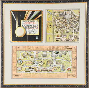
Sold2022Framed Tony Sarg 1939 World's Fair Pictorial MapTony Sarg (American, 1880-1942), "The New York 1939 Official World's Fair Pictorial Map Created by Tony Sarg 25¢" cover and Transportation Zone maps, three pieces matted and under glass in paintedSee Sold Price
Sold2021Pictorial Map Mohawk IndiansMap of the Land of The Mohawks of Sir William Johnson, of the Palatines and the Mohawk Dutch. Edwin G. Conde, 1932. Native Americans historical map, Counties in New York State. 18 3/4" x 34 1/4".See Sold Price
Sold20161936 Illustrated Map of Peiping (Beijing) in EnglishColonel Frank Dorn (American, 1901-1981), Illustrated map of Beijing or Peking, China, published in Tientsin-Peiping, China by Peiyang Press, 1936. Representing the golden age of pictorial maps, an icSee Sold Price
Featured2 days LeftJasper521795 Lewis Map of Maryland -- The State of Maryland, from the best Authorities$360
7 days LeftBrandywine Valley AuctionsVintage American School New York Artist Roger Selchow Abstract Mid Century Modern Watercolor Signed$50
Freeman's | Hindman[WESTERN AMERICANA - MINING]. Cabinet card of a California gold miner with his equipment. $100
Freeman's | Hindman[MAPS]. A group of 8, incl. 5 maps of North America, one of the western hemisphere, & 2 engravings.$150(1 bid)
Freeman's | Hindman[MAPS-THE AMERICAS]. 11 maps, incl. [Herrera y Tordesillas]. Descripcion de las Yndias Ocidentales. $250
BonhamsPEARY'S COPY OF AN EARLY NORTH AMERICAN MAP. PEARY, ROBERT E. 1856-1920.] DOBBS, ARTHUR. 1689-17...$220(3 bids)
16 hrs LeftDonny Malone AuctionsSigned A Levine, Oil on Canvas Painting Western American Desert Landscape$10(1 bid)
12 hrs LeftOAB AuctionsWill Bullas Original Watercolor Painting Western Native American Signed Art$250
1 day LeftOAB AuctionsBill Nebeker The Medicine Shield Bronze Sculpture Signed Western Native American$750
4 days LeftSwann Auction Galleries(AMERICAN REVOLUTION--1776.) Map titled "Boston and the Adjacent Country, with the Stations of the$750


![Color pictorial bird's-eye airline route maps 1929: Heading: (Aviation - pictorial route maps) Author: Title: Western Air Express: Travel by Air, Speed - Comfort - Dependability Place Published: [California?] Publisher:Western Air Express Date Pu](https://p1.liveauctioneers.com/642/204898/103985846_1_x.jpg?height=310&quality=70&version=1621652446)

![Large Check Collection-Oklahoma Territory/Oklahoma [151551]: Lot of 67. One of the better pieces is the Carson Drug Company of Tecumseh with a Native American pictorial. Other banks include the Bank of Waukomis, Tonkawa State Bank, State Bank of Terlton, Dewey](https://p1.liveauctioneers.com/2699/254720/132472025_1_x.jpg?height=310&quality=70&version=1657566291)


![[WESTERN AMERICANA - MINING]. Cabinet card of a California gold miner with his equipment. (1 of 0)](https://p1.liveauctioneers.com/dist/images/placeholder.jpg?height=282&quality=70)


![PEARY'S COPY OF AN EARLY NORTH AMERICAN MAP. PEARY, ROBERT E. 1856-1920.] DOBBS, ARTHUR. 1689-17... (1 of 3)](https://p1.liveauctioneers.com/1043/333441/180036747_1_x.jpg?height=282&quality=70&version=1719180533)


