Sold20221600 c. Mercator/Hondius Map of England and Wales --Title: 1600 c. Mercator/Hondius Map of England and Wales -- Anglia Regnum Cartographer: Mercator/Hondius Year / Place: 1595-1602, Amsterdam Map Dimension (in.): 13.8 X 18.2 in. This attractive map ofSee Sold Price
Sold2017Hondius: Antique Map of Chile, 1635Title: Chili. Rare English edition of the Mercator-Hondius map of Chile Map maker: Henricus Hondius Place and Year: Amsterdam, c. 1635 Dimensions: 48. 3 x 36.8 cm (19 x 14.5 in) Technique: CopperplateSee Sold Price
2017Hondius / Mercator: Map of Japan & Korea, 1630Map: 1630 Hondius / Mercator Map of Japan and Korea - Iaponia Cartographer: J. Hondius / G. Mercator Year / Place: 1630 c. Amstredam Map Dimensions: 13.4 x 17.4 in. Condition: Excellent - very good coSee Sold Price
Sold2017Hondius/Mercator: Antique Map of Japan & Korea, 1630Map: 1630 Hondius / Mercator Map of Japan and Korea - Iaponia Cartographer: J. Hondius / G. Mercator Year / Place: 1630 c. Amstredam Dimensions: 13.4 x 17.4 in. Condition: Sharp strike with the issuedSee Sold Price
Sold2022(5) ANTIQUE MAPS, MERCATOR & DE WITT, 17TH C.(lot of 5) Antique maps, early 17th c., published by Gerardus Mercator (Belgian, 1512-1594), likely from the "Mercator Hondius Atlas," published after his death c.1619, and Fredeick De Witt (Dutch, 16See Sold Price
Sold201818th C. Map of Australia w/Strait of Magellan18th c. framed map of Australia w/the Strait of Magellan. Copper engraved map, hand colored, w/ large colored pictorial cartouche, by Bernaidus Joannis Manasterienfis. Visible paper measures approximaSee Sold Price
Sold2023Jodocus Hondius and Gerardus Mercator: India OrientalisJodocus Hondius and Gerardus Mercator: India Orientalis Engraved map with hand-coloring, c. 1606, with label from I.D.L. Antiques, Hong Kong. 13 3/4 x 18 3/4 in. (sight), 23 x 28 in. (frame). PropertySee Sold Price
Sold2020Hondius Map of MoroccoHONDIUS, Jodocus (1563-1612) / MERCATOR, Gerard (1512-1594). [Morocco] Fessae et Marocchi Regna. Engraving with original hand color. Amsterdam, c. 1606 or later. 17 3/4" x 21" sheet. Comparable: Old WSee Sold Price
Sold2023Détroit de Magellan. Strait of Magellan. Chile. BONNE 1790 old antique map[Voyage des Capitaines Byron, Vallis et Carteret] Détroit de Magellan avec les Plans des principaux Ports, Bayes &c. de ce Détroit // Havre Swalow ou de l'Hirondelle // Baye du Cap Upright // BaSee Sold Price
Sold2016Strait of Magellan, Jodocus Hondius 1606-33Title: Freti Magellanici ac novi Freti vulgo Le Maire Subject: Strait of Magellan Maker: Jodocus Hondius Date: 1606-33, Amsterdam Size: 15.1 x 19.25 inches This is one of the best known early maps ofSee Sold Price
Sold2016Early Hand Colored Map of the Ottoman EmpireEarly hand colored map of the Ottoman Empire after Gerardus Mercator (Belgian, 1512-1594) and Jodicus Hondius II (Belgian, 1563-1612), printed c. 1613-1616. Framed, not examined out of frame. Sight siSee Sold Price
Sold20191613 Mercator/Hondius Map of Caribbean Islands -- CubaTitle/Content of Map: 1613 Mercator/Hondius Map of Caribbean Islands -- Cuba Insula [on sheet with] Hispaniola Insula [and] Insula Iamaica [and] Ins. S. Ioannis [and] Is. Margareta cum Confiniis Date:See Sold Price
Sold20231623 Mercator/Hondius Map of Russia and Scandinavia -- Russia cum ConfinijsTitle: 1623 Mercator/Hondius Map of Russia and Scandinavia -- Russia cum Confinijs Cartographer: Mercator/Hondius Year / Place: 1623, Amsterdam Map Dimension (in.): 13.9 X 18.7 in. This ia a beautifulSee Sold Price
Sold2021Mercator & Hondius 1613 Map of Northern IrelandDESCRIPTION: Map depicting Down & Antrim Counties by cartographers Mercator and Hondius. Ornate with title cartouche incorporating distance scale. Conservation framed. MEASUREMENTS: Map 14" high x 15"See Sold Price
Sold2018Mercator / Hondius: Antique Map Cuba / Hispaniola, 1607Title/Content of Map: Cuba Insul/Hispaniola Cartographer: Mercator / Hondius Place & Date: Amsterdam / 1607/1620s Size: 7 1/8" x 5 5/8" Condition: full color; overall age-toning and some staining; resSee Sold Price
Sold2020Mercator-Hondius Mexico Map ca. 1638Hendrik Hondius (1588-1651), Jan Jansson (1588-1664), and Gerardus Mercator (1512–1594), "Nova Hispania et Nova Galicia," Amsterdam: Hondius & Jansson, ca. 1638. Hand colored map of Mexico fromSee Sold Price
Sold2017Mercator/Hondius: Antique Map of Cuba & Hispaniola 1630Map: Cuba Insula/Hispaniola Insula etc. Cartographer: Mercator / Hondius / Cloppenburgh Place & Date: Amsterdam / 1630 Size: 10" x 7 3/8" Condition: light overall age-toning; some nicks and tears alonSee Sold Price
Sold2020Mercator & Hondius C1610 Map of Alsace, France (Fault)"Alsatia Inferior" Copper Engraved Map Published 1607-10, Amsterdam & Dordrecht for "Atlas Minor" by Jodocus Hondius & Gerard Mercator. Paper Size: 8.5 x 7 inch (22 x 18cm) Large chip at bottom, slighSee Sold Price
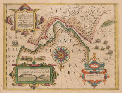
Sold2017Mercator: Strait of Magellan, Terra del Fuego, 1613Exquisita & magno aliquot mensium periculo Lustrata et iam retecta Freti Magellanici Facies . . . By: Gerard Mercator. Date: 1613 / Amsterdam. Dimensions: 14 x 18 inches (35.5 x 45.7 cm) This is an auSee Sold Price
Sold2023J. DE HONDT, COLOR MAP OF STRAITS OF MAGELLANJoost de Hondt (Belgian 1563-1612), "Freti Magel Lanici Ac Novi Freti Vulgo, Le Maitre Exactissima Delineatio", hand colored map of the Straits of Magellan, Le Maire Strait, Fire Lands and the southerSee Sold Price
Sold20241635 MERCATOR HONDIUS CAMBRIA WALLIA MAP WALESMercator Hondius 1635 Cameria Sive Wallia Map of Wales / England, Detailed and Hand Colored. 7" x 9". 11" x 12.25" Matted. Very nice condition.See Sold Price
Sold20231630 c. Hondius Map of Northern Africa -- BarbariaTitle: 1630 c. Hondius Map of Northern Africa -- Barbaria Cartographer: J Hondius Year / Place: 1630 c., Amsterdam Map Dimension (in.): 13.7 X 18.4 in. This is an attractive map of North Africa, focusSee Sold Price
Sold202417TH C. MERCATOR'S MAP - SMALLER ISLANDS ANGLESEA CHANNELL ISLANDS17TH CENTURY (1636) HAND COLORED MERCATOR'S MAP OF THE SMALLER ISLANDS, ANGLESEY CHANNELL ISLANDS, ISLE OF WIGHT, JARSAY, GARNESAY - FRAME MEASURES APPROX. 21" X 17"See Sold Price
Sold2017Hondius Map of Asia, 1606Map: 1606 c. Hondius Map of Asia -- Asiae Nova Descriptio Cartographer: J Hondius Year / Place: 1606 c., Amsterdam Map Dimension: 14.8 X 19.7 in. This is an excellent map of Asia. It is believed to beSee Sold Price
6 days LeftJasper521630 EGYPT MAP copper engraving ANTIQUE from ENGLISH ED. Mercator-Hondius Atlas$35
4 hrs LeftJasper52Extremité Meridionale de l'Amérique Tierra del Fuego Magellan Str BONNE 1788 map$35
Jun 08Early American History Auctionsc 1730 Hand-Colored Colonial Era Map of the Americas, California shown as an Island, Matted + Framed$500(1 bid)
6 days LeftMark Louis Weseloh Estate LiquidationsSix - 17th c. Maps of Europe, Asia, England, Germany x2, Crete, Greece.8 1/4" x 6 5/8".$300
Jun 08Simpson Galleries, LLC.JODOCUS HONDIUS (1563-1612) A JACOBEAN MAP, "Northamptonshire," AMSTERDAM, 1610$150
4 days LeftGold Coast Auctioneers17th-19th c. French Wall Art Collection Map City Sea Scapes Scenes etc.$50


![Hondius Map of Morocco: HONDIUS, Jodocus (1563-1612) / MERCATOR, Gerard (1512-1594). [Morocco] Fessae et Marocchi Regna. Engraving with original hand color. Amsterdam, c. 1606 or later. 17 3/4" x 21" sheet. Comparable: Old W](https://p1.liveauctioneers.com/1968/169571/85465312_1_x.jpg?height=310&quality=70&version=1590242353)
![Détroit de Magellan. Strait of Magellan. Chile. BONNE 1790 old antique map: [Voyage des Capitaines Byron, Vallis et Carteret] Détroit de Magellan avec les Plans des principaux Ports, Bayes &c. de ce Détroit // Havre Swalow ou de l'Hirondelle // Baye du Cap Upright // Ba](https://p1.liveauctioneers.com/5584/294908/156576972_1_x.jpg?height=310&quality=70&version=1688565030)


![1613 Mercator/Hondius Map of Caribbean Islands -- Cuba: Title/Content of Map: 1613 Mercator/Hondius Map of Caribbean Islands -- Cuba Insula [on sheet with] Hispaniola Insula [and] Insula Iamaica [and] Ins. S. Ioannis [and] Is. Margareta cum Confiniis Date:](https://p1.liveauctioneers.com/5584/144953/73284144_1_x.jpg?height=310&quality=70&version=1562102885)