Sold20201814 Arabia, Egypt, Abyssinia, Red Sea &c.This is a striking map of Arabia, Abyssinia, the Red Sea and surrounding regions with original color including shaded borders of regions, and mountain ranges marked with hachures. The sandy deserts ofSee Sold Price
Sold2017Thomson: Map of Arabia, Egypt, Abyssinia, Red Sea, 1814Map: Arabia, Egypt, Abyssinia, Red Sea Cartographer: Thomson Place & Date: Edinburgh / 1814/1817 Size: 23 1/4" x 19 7/8" Condition: some spotting and age toning The beautifully detailed map of ArabiaSee Sold Price
Sold2024ASSORTED MAPS US, ARABIA, EGYPT, & ETCLarge assembled 19th hand colored maps. Various countries. 1) Early 19th century folding map titled ARABIA, EGYPT, ABYSSINIA, RED SEA & Co. Published in 1817. Large map of Arabia andadjacent countriesSee Sold Price
Sold20231843 SDUK Map of Arabian Peninsula, Red Sea, Egypt -- Arabia with Egypt, Nubia and AbyssiniaTitle: 1843 SDUK Map of Arabian Peninsula, Red Sea, Egypt -- Arabia with Egypt, Nubia and Abyssinia Cartographer: SDUK Year / Place: 1843, London Map Dimension (in.): 13.1 X 15.9 in. This a highly detSee Sold Price
Sold20191787 Eyles Irwin Voyages Red Sea Arabia & Egypt Middle1787 Eyles Irwin Voyages Red Sea Arabia & Egypt Middle East Illustrated MAPS 2v A rare, impressive edition of Eyles Irwin’s “Series of Adventures” – a work on his voyages and excursions in theSee Sold Price
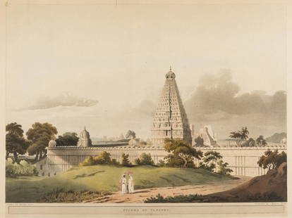
Sold2017India and the Middle East.- Salt (Henry) Pagoda atIndia and the Middle East.- Salt (Henry) Pagoda at Tanjore; The Pass of Atbara in Abyssinia, both from: 'Twenty-Four Views in St Helena, The Cape, India, Ceylon, The Red Sea, Abyssinia and Egypt', aquSee Sold Price
Sold2018Carte de L'Arabie, du Golfe Persique et de la Mer RougeTITLE/CONTENT OF MAP: 'Carte de L'Arabie, du Golfe Persique et de la Mer Rouge, avec l'Egypte, la Nubie et l'Abissinie' A map of Arabia, the Nile valley & Abyssinia, with the Red Sea and Persian GulfSee Sold Price
Sold20241780 Eyles Irwin "A Series Of Adventures In The Course Of A Voyage Up The Red Sea"On the coast of Arabia and Egypt; and of A Route Through The Defarts Of Thebais, hither to unknown to the European traveller, in the year 1777, Illustrated with maps and cutsSee Sold Price
Sold2019Egypt & Arabia 19th Cent. Lot of 5 MapsLot of 4 19th Cent Lithographed and Engraved Maps. Examples by SDUK, Weller/Weekly Dispatch, William Collins, and Johnston. Together with a large 20th Cent. Admiralty Chart of the Red Sea, published 1See Sold Price
Sold2017Bellin: Map of the Coast of Arabia, 1740Carte de la Coste d'Arabie, Mer Rouge et Golfe de Perse. Bellin's highly detailed map of the "coast of Arabia, the Red Sea and the Persian Gulf," including eastern Egypt, the Arabian Peninsula, greateSee Sold Price
Sold2017Bellin: Antique Map of Arabia & Red Sea, 1728Map: 1728 Bellin Map of Arabia and Red Sea -- Carte de la Coste d'Arabie, Mer Rouge, et Golfe de Perse Cartographer: J Bellin Year / Place: 1740, Paris Dimensions: 8.6 x 9.8 in. Condition: Very good.See Sold Price
Sold2020(EGYPT.) Schenk, Peter; and Valk, Gerard. Aegypti(EGYPT.) Schenk, Peter; and Valk, Gerard. Aegypti Recentior Descriptio: Aegyptis & Turcis Elchibith; Arabibus Mesre & Misri, Hebraeis Mitsraim. Double-page engraved map of Egypt, the Red Sea and partSee Sold Price
Sold2024North East Africa. Egypt Abyssinia Arabia Abu Dhabi Sharja. COLTON 1869 mapTITLE OF MAP (NOT PRINTED ON THE PAGE):'Africa - north eastern sheet' DATE PRINTED: 1869 IMAGE SIZE: Approx 42.0 x 33.5cm, 16.5 x 13.25 inches (Large) TYPE: Antique engraved hand coloured atlas map COSee Sold Price
Sold2020Henry Salt,(British 1780-1827)Henry Salt,(British 1780-1827) View of Grand Cairo and The Pyramids of Cairo (two prints) from Twenty-four Views in St. Helena, the Cape, India, Ceylon, the Red Sea, Abyssinia and Egypt Drawn by HenrySee Sold Price
Sold2022Joseph Moxon Holy Land Color Engraving, 17th C.Joseph Moxon (English, 1627-1691) Holy Land engraving with hand-coloring, Israel's Peregrination, or the Forty Years Travels of the Children of Israel out of Egypt through the Red Sea, and the WildernSee Sold Price
Sold20191700 c. Sanson Map of the Arabian Peninsula and the RedTitle/Content of Map: 1700 c. Sanson Map of the Arabian Peninsula and the Red Sea -- Arabia Petrea, Deserta et Felix Per N. Sanson Date: c. 1700 Cartographer: Based on N. Sanson Size: 7.5 X 9.5 in. ThSee Sold Price
Sold2019Arabia With Egypt, Nubia and AbyssiniaTitle: Arabia With Egypt, Nubia and Abyssinia Publication Date: 1843-09-15 Cartographer: WALKER, J. & C. Publisher: SOCIETY FOR THE DIFFUSION OF USEFUL KNOWLEDGE/S.D.U.K. Size: 12.5Height - 15.5WidthSee Sold Price
2018ARABIA. Haj routes. Deba/Dubai Abothubi/Abu Dhabi.Reserve Reduced! TITLE/CONTENT OF MAP: 'ARABIA WITH EGYPT, NUBIA, AND ABYSSINIA.' The map shows Hajj routes to Mecca. The UAE Coast is marked as "Pirate Coast", and Abothubi (Abu Dhabi), Deba (Dubai)See Sold Price
Sold2018ARABIA. Haj routes. Deba/Dubai Abothubi/Abu Dhabi.Reserve Reduced! TITLE/CONTENT OF MAP: 'ARABIA WITH EGYPT, NUBIA, AND ABYSSINIA.' The map shows Hajj routes to Mecca. The UAE Coast is marked as "Pirate Coast", and Abothubi (Abu Dhabi), Deba (Dubai)See Sold Price
Sold20221777 Rocher History of EGYPT Pharaoh Khufu Bible MOSES1777 Rocher History of EGYPT Pharaoh Khufu Bible MOSES Crossing Red Sea MAP 2v Pierre GueÌrin du Rocher was an 18th-century French Jesuit controversialist who is primarily remembered for his work TheSee Sold Price
Sold20211794 Anville Map of the Arabian Peninsula and Red SeaTitle: 1794 Anville Map of the Arabian Peninsula and Red Sea -- A New Map of Arabia Divided into its Several Regions and Districts from Mons. D'Anville… Cartographer: J d'Anville / Larie and WhittleSee Sold Price
Sold2022ONNIG OF CAIRO EGYPT DEMI PARURE MUSEUM REPRODUCTIONOriginal box; "made of red sea coral and mummy beads", labeld "United Arab Republic" which existed from 1958-1971; consists of (1) bracelet: gold tone multi-strand with filigree clasp; (1) choker stylSee Sold Price
Sold20211882 Map of Arabia and the Persian GulfTitle: 1882 Map of Arabia and the Persian Gulf Author: Blackie Medium: Ink on Paper Dimensions: 22"X15" Description: Map of Arabia and the Persian Gulf dated 1882. It captures the Red Sea. Part of theSee Sold Price
Sold2022Marc Chagall - The people of Israel go out of the land of Egypt. (EXODUS 13 : 18-22). The IsraelitesMarc Chagall - Biblical Heliograviures The people of Israel go out of the land of Egypt. (EXODUS 13 : 18-22). The Israelites pass through the Red Sea while the first chariots of the Egyptian army areSee Sold Price
5 days LeftSanta Cruz Auction CompanyMinor Kilbourne Kellogg (1814-1889) Early Orientalist Egyptian Painting$6,500
Jun 09Eastern Art Auction HouseA Qing Dynasty Qianlong Blue And White Glazed Red Sea Dragon Pattern Moon Embracing Vase$100
2 days LeftLuxe Auctioneers, IncROLEX DOUBLE RED SEA-DWELLER TROPICAL COLOR CHANGE DIAL REF. 1665 WRISTWATCH CIRCA 1968$25,000
Jun 03Heritage Auctions54173: Rolex, "Double Red" Sea-Dweller Submariner, Stai$15,000
4 days LeftTrillium Antique Prints & Rare BooksDavid Roberts - Front Elevation of the Great Temple of Aboosimble, Nubia$200
4 days LeftTrillium Antique Prints & Rare BooksDavid Roberts - The Great Sphinx, Pyramids of Gizeh$200
May 29BidhausVintage Red Classic Floral 10X14 Extra Large Area Rug Oriental Home Decor Carpet$10(1 bid)
Swann Auction GalleriesMcManus, Blanche (1869-1935) Poster Advertising Kipling's Captains Courageous.$175
Jun 02Global Auctions CompanyPre Columbian Peru NAZCA Polychrome pottery bowl, with stylized sea lion$800
Jun 02Schilb Antiquarian Rare Booksc1700s RARE Arabic Handwritten Manuscript Middle East Persia Journal ARABIA$130(5 bids)
24 hrs LeftThousand Planet Auction HouseAn Ancient Egyptian Carnelian Amulet of Pataikos, Late Period, c. 700-30 BCE$5(1 bid)