Sold20201784 Large Map of GermanyA Correct Map of the North West part of Germany…. published by Harrison and Co., London, 1784. Fine, folding, measures 21 x 16.5". Reserve: $30.00 Shipping: Domestic: Flat-rate of $7.00 to anywhereSee Sold Price
Sold2019Gross, Alexander 1920 Lot of 6 Large Maps. GermanyLarge Lithograph Maps Published 1920, London for "The Daily Telegraph Victory Atlas of the World" by Alexander Gross. Centre fold as published. Paper Size: 25 x 19.5 inch (64 x 49cm) Good ConditionSee Sold Price
Sold202118th C Large Handcolored Mercator Map GermanyLarge beautifully handcolored map of Braunswyck and Meydburg after Gerard Mercator circa 1640, this being an 18th century restike.. Printed at Amsterdam. Measures 23 x 19". Fine, reinforced central veSee Sold Price
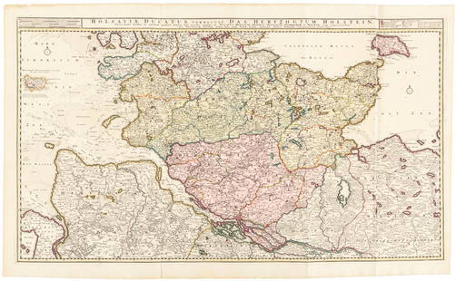
Sold2016Large map of Holstein, Germany 1720Heading: Author: Visscher, Nicolas Title: Holsatiae Ducatus Vernadule das Hertzogtum Holetein... Place Published: Amsterdam Publisher:Pieter Schenk, Jr. Date Published: c.1720 DescriptSee Sold Price
Sold2018Thomson: Antique Map of Southern Germany, 1817Title/Content of Map: 'Germany, south of the Mayne'. This large, decorative map shows Southern Germany, including the Kingdom of Bavaria, Hesse-Darmstadt, the Grand Duchy of Baden, the Kingdom of WurtSee Sold Price
Sold2023Exquisite vertical format vintage map of Germany – 1865Beautiful and large two-page map of Germany in an unusual vertical format. Covers the region from the Baltic Sea to the Adriatic Sea. This historical document shows the two great regions of Germany, PSee Sold Price
Sold2019Bartholomew, John 1922 Lot of 8 Large Maps of EuropeIncl Belgium/Holland, Spain/Portugal - East & West, Northern Italy/Austria, Southern Italy, Central European States, Germany - South & West. Large Lithograph Maps Published 1922 by The Times, London fSee Sold Price
Sold2019Philip, George 1856 LG Hand Col Map. Germany North PartLarge Folio Lithograph Map Published Published 1856 by George Philip, Liverpool for "Philips' Commercial Atlas of the World" Paper Size: 26 x 21 inch (66 x 53cm) Light horizontal bend in centre. NeatlSee Sold Price
Sold2019Philip, George 1856 LG Hand Col Map. Germany South PartLarge Folio Lithograph Map Published Published 1856 by George Philip, Liverpool for "Philips' Commercial Atlas of the World" Paper Size: 26 x 21 inch (66 x 53cm) Light horizontal bend in centre. NeatlSee Sold Price
Sold2023Gross, Alexander 1920 Lot of 26 Large Maps. EuropeIncl Germany, Austria, Russia, Netherlands, Belgium/Luxembourg, Norway/Sweden, Denmark/Iceland, Switzerland, Italy, France/Switzerland, Spain/Portugal, Europe Continent. Large Lithograph Maps PublisheSee Sold Price
Sold2019Bartholomew, John 1922 Mixed Lot of 9 Large MapsIncl Mapping of the World, World Climate, Germany East, Southern Russia, Asia Minor/Syria/Mesopotamia, Palestine, Indian Ocean, North America - Political, North Atlantic Ocean. Large Lithograph Maps PSee Sold Price
Sold2022Universal Atlas 1893 Lot of 9 Large Maps of EuropeIncl Austrian Alps, Switzerland, Spain/Portugal, Austria/Hungary, Germany, France, England/Wales Lithograph Maps Published 1893 by Cassell & Co., London for "The Universal Atlas" Centre fold as issuedSee Sold Price
Sold2019"Germany, north of the Mayne" (Main). Prussia HanoverTITLE/CONTENT OF MAP: 'Germany, north of the Mayne' DATE PRINTED: 1817 IMAGE SIZE: Approx 53.5 x 65.0cm, 21 x 25.75 inches (Large); Please note that this is a folding map. TYPE: Antique early 19th cenSee Sold Price
Sold2018SDUK: Antique General Map of Germany, 1845Title/Content of Map: 'GERMANY, General map' Austria-Hungary & Switzerland. Population table. Date Printed: 1845 Image Size: Approx 34.0 x 41.0cm, 13.25 x 16 inches (Large) Type: Antique steel engraveSee Sold Price
Sold2020c1737 Homann Map Saxony GermanyLarge handcolored map by Johann Baptist Homann, printed at Nuremburg circa 1737 entitled "Circulus Saxoniae Inferioris…...", Laid down to paper, Fine condition, measures 23 x 19.5". Reserve: $100.00See Sold Price
Sold2022Lizars, Daniel 1831 LG Rare HC Map. Franconia, GermanyLarge Folio Copper Engraved Map Published 1831-2 by John Hamilton, Successor to Daniel Lizars, Edinburgh for "The Edinburgh Geographical and Historical Atlas..." First Edition by Daniel Lizars. Very fSee Sold Price
Sold2023Lizars, Daniel 1831 LG Rare HC Map. Franconia, GermanyLarge Folio Copper Engraved Map Published 1831-2 by John Hamilton, Successor to Daniel Lizars, Edinburgh for "The Edinburgh Geographical and Historical Atlas..." First Edition by Daniel Lizars. Very fSee Sold Price
Sold2020Bartholomew, John 1922 Lot 7 Maps. Baltic, Germany etcIncl Germany West, Germany East, Southern Scandinavia/Denmark, Poland/Czecho-Slovakia, Siberia, Northern Russia/Finland, Baltic States/East Prussia. Large Lithograph Maps Published 1922 by The Times,See Sold Price
Sold2019Bartholomew, John 1922 Lot of 8 European MapsIncl Germany - East, Germany - West, Germany - South, Central European States, Switzerland, Spain/Portugal - East, Spain/Portugal - West, Belgium/Holland. Large Lithograph Maps Published 1922 by The TSee Sold Price
Sold2022Lizars, Daniel 1831 LG Rare HC Map. Upper Saxony, GermanyLarge Folio Copper Engraved Map Published 1831-2 by John Hamilton, Successor to Daniel Lizars, Edinburgh for "The Edinburgh Geographical and Historical Atlas..." First Edition by Daniel Lizars. Very fSee Sold Price
Sold2023Lizars, Daniel 1831 LG Rare HC Map. Upper Saxony, GermanyLarge Folio Copper Engraved Map Published 1831-2 by John Hamilton, Successor to Daniel Lizars, Edinburgh for "The Edinburgh Geographical and Historical Atlas..." First Edition by Daniel Lizars. Very fSee Sold Price
Sold2022Spruner, Karl C1854 Antique Map of the British Isles"Die Britischen Inseln nach ihrer kirchlichen Eintheilung bis zur Reformation" Large Steel Engraved Map with outline hand color Published C1854, Gotha, Germany for "Historisch-geographischer Hand-AtlaSee Sold Price
Sold2023Portfolio of Vintage European MapsLarge artists portfolio with vintage maps of various European countries and cities, including: Germany, Rome, Vienna, Paris, Dresden, and others. Approximately 30 pieces. As is, as shown. Provenance:See Sold Price
Sold2021London 1800 Stockdale's Geography with MapsA Geographical, Historical and Political Description of … Germany, Holland, The Netherlands, Switzerland, Prussia, Italy, Sicily, Corsica & Sardinia. London: John Stockdale, 1800. Large 4to -- 10 xSee Sold Price
5 days LeftTrillium Antique Prints & Rare BooksDe Jode, Rare, pub. 1593 - Electors of the Holy Roman Empire (Ordines Sacri Romani Imp: Ab Ottone$100(1 bid)
2 days LeftJasper52South Siberia & Turkestan. Central East Asia. Mongolia China. BAEDEKER 1912 map$40
2 days LeftJasper52La Tartaria Indipendente… Central Asia, Caspian Sea & Caucasus. ZATTA 1785 map$100
5 days LeftEagles Corps International LLCWWII Extensive German Document Group - Iron Cross 1st and 2nd Class$210(4 bids)
Jun 09Austin Auction GalleryLARGE GERMAN NYMPHENBURG PORCELAIN FIGURE, BACCHUS ON TREE STUMP$150(1 bid)
315 Lots AwayHermann Historica GmbHA large German ivory-mounted silver tankard with putti, Berlin, W. Schwechten, circa 1900See Sold Price
25 Lots AwayHermann Historica GmbHA large German wrought iron signaling canon, 17th/18th cent.See Sold Price