Sold20221866 Chart of San Juan Island in Washington --Title: 1866 Chart of San Juan Island in Washington -- Washington Sound and Approaches Washington Territor Cartographer: US Coast Survey Year / Place: 1866 Map Dimension (in.): 17.5 X 16 in. This superSee Sold Price
Sold2021Painted & Dye ChartGroup of 3 pieces. An original oil on board signed Janet Cavelero Navajo Dye Chart & Framed Mola from San Blas IslandSee Sold Price
Sold20221855 Chart of Near-San Francisco Farralon Islands --Title: 1855 Chart of Near-San Francisco Farralon Islands -- Sketch of South Farallon Island, Pacific Ocean Cartographer: US Coast Survey Year/Place: 1855 Dimensions: 13.4 X 12.6 in. Description: ThisSee Sold Price
Sold2019BRITISH COLUMBIA NEW CALEDONIA VANCOUVER ISLAND. SanTITLE/CONTENT OF MAP: 'British Columbia (New Caledonia); Vancouver Island' The San Juan islands are shown on the map as British, although at the time of publication they were disputed territory. The USee Sold Price
Sold2019Jean-Baptiste-Camille Corot - Island San BartolomeoArtist: Jean-Baptiste-Camille Corot Title: Island San Bartolomeo Year: 1875 Dimensions: 16in. by 20in. Edition: From the rare limited edition Medium: Original dSee Sold Price
Sold2021Jean-Baptiste-Camille Corot - Island San BartolomeoArtist: Jean-Baptiste-Camille Corot Title: Island San Bartolomeo (1875) Year: 1875 Dimensions: 9 7/8in. by 12 7/8in. Edition: From the rare limited edition Medium:<See Sold Price
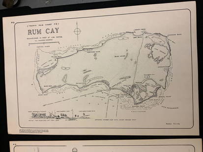
Sold2021Boating maps, rum cay, conception island, San Salvador.Maps from 1981 tropic Isle publishers, Inc By Harry Kline, Rum Cay, Conception island, San Salvador. Size 11“ x 17“See Sold Price
Sold2023SANTA CLAUS CHRISTMAS 1943 US NAVAL HOSPITAL MENU Treasure Island SAN FRANCISCOSANTA CLAUS CHRISTMAS 1943 US NAVAL HOSPITAL MENU Treasure Island SAN FRANCISCO SANTA CLAUS CHRISTMAS 1943 US NAVAL HOSPITAL MENU Treasure Island SAN FRANCISCO CHRISTMAS DAY 1943 U. S. Naval HospitalSee Sold Price
Sold2017Framed Italian Engraved Hand Colored Map of theFramed Italian Engraved Hand Colored Map of the Adriatic Sea, with Latin and Italian writing; focusing on three islands: San Domino, Santo Niccola, and La Caprara; written in Latin at the top "InsulaeSee Sold Price
Sold2019[GRABHORN PRINTING]. CLEMENS, Samuel Langhorne, ("Mark[GRABHORN PRINTING]. CLEMENS, Samuel Langhorne, ("Mark Twain," 1835-1910). Letters from the Sandwich Islands. San Francisco: The Grabhorn Press, 1937. 8vo. Numerous illustrations printed in color. OriSee Sold Price
Sold2019Claes Oldenburg - Proposed Colossal Monument forArtist: Claes Oldenburg Title: Proposed Colossal Monument for Alcatraz Island San Francisco in the form of a Colossal Drum Pedal #2 Year: 1973 Dimensions: 35 3/8in. by 25 5/8in. ESee Sold Price
Sold2017Colorful original painting, Army Port, San Francisco,Artist unknown, Didero (American, 20th c.) Bright and colorful modern oil painting of the army port, San Francisco, located on Treasure Island, San Francisco Bay. This work was created in the 1940s, pSee Sold Price
Sold2021Golden Gate International Exposition CollectionAbout 20 items from the Golden Gate International Exposition held on Treasure Island, San Francisco 1939-40. Official Guide; brochure from the Argentine Republic exhibit; cookbook for dried fruit reciSee Sold Price
Sold2020Collection of 1939 San Francisco InternationalCollection of 1939 Treasure Island San Francisco Golden Gate International Exposition World's Fair Photos Mounted in Tin Frames and Antique German Mesh Expandable Purse. Labeled International MutoscopSee Sold Price
Sold2023Antique Map of Yerba Buena Island, CaliforniaMap Of Yerba Buena Island, San Francisco. Marked: "Yerba Buena Island San Francisco Harbor, Cal, AM. Photo Lithographic Co. N.Y. (Osborne's Process)" Approximately 22.0L x 24.0W inSee Sold Price
2017Antique Nautical Chart of San Francisco Harbor, 1885Map: 1885 British Admiralty Chart of San Francisco Harbor -- North America; West Coast; San Francisco Harbour from United States Coast Survey 1877 Date Printed: 1885, London Cartographer: British AdmiSee Sold Price
Sold2016Rare French chart of San Francisco Bay 1843Heading: Author: Du Petit Thouars, Abel Aubert Title: Croquis des Atterages de la Baie de San-Francisco (Haute Californie). Leve et Dresse en 1837 à bord de la Fregate la Vénus sous les ordres de MSee Sold Price
Sold2018British Admiralty: Antique Chart of San FranciscoTitle/Content of Map: 1885 British Admiralty Chart of San Francisco Harbor -- North America; West Coast; San Francisco Harbour from United States Coast Survey 1877 Date Printed: 1885, London CartograpSee Sold Price
Sold2021Kerry Hallam Acrylic on Coastal Chart - Long IslandKerry Hallam (British 1937-2020) Acrylic on Coastal Chart - Long Island Sound, Nantucket Sound and New England Coastline, signed lower left 26 in. x 43.5 in. Overall 29.5 in. x 47.5 in. Dimensions 26See Sold Price
Sold20181700 Pacific sea chart with Island of California andTitle: Mer de Sud ou Pacifique contenant l'Isle de Californe. Map maker: Pierre Mortier Place and Year: Amsterdam, 1700 Dimensions: 60 x 74.5 cm (23.6 x 29.3 in) Technique: Copperplate engraving ColorSee Sold Price
Sold2018Armenia.- Venice.- Issaverdenz (J) The Island of SanArmenia.- Venice.- Issaverdenz (J.) The Island of San Lazzaro or the Armenian Monastery near Venice, 20 mounted albumen prints, offsetting, text ff. browned, some spotting, original red decorative cloSee Sold Price
Sold2015U.S. Coast Survey Map of South Farallon Island and San(lot of 2) Alexander Dallas Bache (American, 1806 - 1867), South Farallon Island, 1855, and San Clemente Island, 1856, U.S. Coast Survey hand-colored copper engraved maps, overalls (with frames): 18"hSee Sold Price
Sold2024Antique 1883 Eldridge's Chart Long Island SoundAntique 1883 Eldridge's Chart Long Island Sound From Newport to New York by Geo. Eldridge, Hydrographer and Published by S. Thaxter & Son. The map is framed in a metal map frame with no glass. The mapSee Sold Price
Sold2023Nautical Chart: PLUM ISLAND TO STRATFORD SHOAL/ LONG ISLAND SOUNDDescription: PLUM ISLAND TO STRATFORD SHOAL/ LONG ISLAND SOUNDMeasurement approximate: 32 x 22 Inches Material: PaperSee Sold Price
5 days LeftJasper52Central America Caribbean Gulf of Mexico chart Ports lighthouses LARGE 1918 map$45
5 days LeftJasper52Bahamas. San Salvador Crooked Rum Cay Mariguana ADMIRALTY chart 1892 (1919) map$140
4 days LeftJohn Moran Auctioneers, Inc.Franz A. Bischoff (1864-1929), "Santa Rosa Island [at] San Pedro Harbor"$3,000
5 days LeftJasper52HAWAII HISPANIOLA. Hawaiian Isles; Haiti San Domingo Dominican Republic 1898 map$20
7 days LeftMynt Auctions1901 Registered German Colony Marshall Islands Cover Jaluit to San Francisco USA$410
Featured5 days LeftJasper52The Bahamas, Cuba & Bermuda "or Summer Islands". THOMSON 1817 old antique map$180
5 days LeftJasper52Cuba, the Bahamas & Bermuda "or Summer Islands". Turks & Caicos THOMSON 1830 map$160
2 days LeftChurchill GalleriesCHART: South Pacific Ocean / SOCIETY ISLANDS - WESTERN GROUP/ HUAHINE TO MAUPITI With the$10
5 days LeftJasper52Grand Bahama & Great Abaco Islands. Bahamas. ADMIRALTY sea chart 1886 (1968) map$140
May 16Zikorn Arts & History ObjectsWest Indies Pt. Manzanilla to San Juan 1844 British Admiralty Map$100
5 days LeftJasper52West India Islands & Caribbean Sea Sheet 2 ADMIRALTY sea chart 1913 (1949) map$120
5 days LeftJasper52Bahamas harbours Pelican Abaco Berry I Jumentos ADMIRALTY chart 1899 (1920) map$140
Featured5 days LeftJasper52Anguilla St. Martin/Maarten Barts. Caribbean. US Navy sea chart 1899 (1917) map$280
5 days LeftMynt Auctions1895 Hawaiian Islands Cover Honolulu HI to New Jersey NJ USA via San Francisco$410
6 days LeftHunt and Peck Estate Services, Inc.Nathaniel Blackmore "The Harbour of Annapolis Royal"$50(1 bid)


![[GRABHORN PRINTING]. CLEMENS, Samuel Langhorne, ("Mark: [GRABHORN PRINTING]. CLEMENS, Samuel Langhorne, ("Mark Twain," 1835-1910). Letters from the Sandwich Islands. San Francisco: The Grabhorn Press, 1937. 8vo. Numerous illustrations printed in color. Ori](https://p1.liveauctioneers.com/197/151909/76680271_1_x.jpg?height=310&quality=70&version=1570472488)


![Franz A. Bischoff (1864-1929), "Santa Rosa Island [at] San Pedro Harbor" (1 of 7)](https://p1.liveauctioneers.com/255/326746/175936481_1_x.jpg?height=282&quality=70&version=1713412391)


