Sold2020ARBUCKLES INDIAN TERRITORY MAP, C.1889Framed colorful card map of the Indian Territory, illustrated with bison, Indians and accoutrements, a chromolithograph, patent date 1889, given as a premium with Arbuckle Brothers coffee and publisheSee Sold Price
Sold20211873 Texas and Indian Territory MapAuthor: Bartholomew Title: 1873 Texas and Indian Territory Map Medium: Ink on Paper Dimensions: 17.5"X13" Map of Texas and the Indian Territory dated 1873. Part of Zell's Descriptive Hand Atlas of theSee Sold Price
Sold20221892 Johnson Map of Oklahoma and Indian Territory -- Map of OklahomaTitle: 1892 Johnson Map of Oklahoma and Indian Territory -- Map of Oklahoma Cartographer: A J Johnson Year / Place: 1892, New York Map Dimension (in.): 5.9 X 8 in. This is fascinating map showing theSee Sold Price
Sold2016Framed and matted Indian Territory map of OKFramed and matted Indian Territory map of Oklahoma. 20" x 17".See Sold Price
Sold2018Arbuckle Indian Territory 1889“Indian Territory.” New York: Arbuckle Bros. Coffee Company, 1889. Ca. 3 x 5. Chromolithograph by Donaldson Brothers. Very good condition. Please note that this lot has a confidential reserve. WheSee Sold Price
Sold2022Gray’s New Map of Texas and Indian Territory, 1884Impressive and huge, hand colored map of the Lone Star State with complete view of Indian Territory. Map features seven insets: (1) The River System of Texas and the Indian Territory; (2) Part of TexaSee Sold Price
Sold20191900 Plat Map of a Section of Cherokee Nation Land --Reserve Reduced! Map Title/Content: 1900 Plat Map of a Section of Cherokee Nation Land -- Cherokee Nation Township 22 North, Range 21 East Cartographer: Indian Territory Map Co. Year / Place: 1900 c.See Sold Price
Sold20181900 Plat Map of a Section of Cherokee Nation Land --Title/Content of Map: 1900 Plat Map of a Section of Cherokee Nation Land -- Cherokee Nation Township 22 North, Range 21 East Date: 1900 c. Muskogee, Ind. Terr. Cartographer: Indian Territory Map Co. SSee Sold Price
Sold2018Asher & Adams: Antique Map of Indian Territory, 1874Title/Content of Map: 1874 Asher & Adams Indian Territory Map -- Asher & Adams Indian Territory and Texas North West Portion Date Printed: 1874, New York Cartographer: Asher & Adams Size: 16.3 x 23.2See Sold Price
Sold2017Lloyd: Map of Kansas and Other Territories, 1872Map: Kansas, and the Territories of Arizona, Colorado, New Mexico, Utah and Indian Territory (antique map) Cartographer: H.H. Lloyd Publisher: Stedman, Brown & Lyon Date: 1872 Size: 15.375 x 24.5 inchSee Sold Price
Sold2021Large Map of Oklahoma & Indian TerritoriesMap of Oklahoma & Indian Territories With map of New Mexico on verso Cartographer: George Franklin Cram Dated: Circa 1900 Type: Color LithographSee Sold Price
Sold20181890 Census Office Map of Indian Territory and OklahomaTitle/Content of Map: 1890 Census Office Map of Indian Territory and Oklahoma -- Map of Indian Territory and Oklahoma Date: 1890, Washington Cartographer: General Land Office / Census Office Size: 22.See Sold Price
Sold20211880 Gray Map of Texas and Indian Territory -- Gray'sTitle: 1880 Gray Map of Texas and Indian Territory -- Gray's New Map of Texas and the Indian Territory Cartographer: F Gray Year/Place: 1880, Philadelphia Map Dimensions (in.): 17 X 26.4 in. DescriptiSee Sold Price
Sold2021Map of Indian Territory & KansasMap of Indian Territory Combined with Map of Kansas on Verso Color Map Dated: 19th century Dimensions: 10 x 6 1/2" Condition Report Good. TextSee Sold Price
Sold2020Indian Territory 1891Title/Content of Map: Indian Territory 1891 Date Printed: 1891 Material/Medium: Paper Size: approx 10.5x14.5 inches Additional Info: Cram's Atlas of the World. Geo. F. Cram, Chicago Reserve: $20.00 SSee Sold Price
Sold2020Indian Territory 1897Title/Content of Map: Indian Territory 1897 Date Printed: 1897 Material/Medium: paper Size: approx. 11x 13.5 inches Additional Info: Cram's Universal Atlas Reserve: $30.00 Shipping: Domestic: Flat-ratSee Sold Price
Sold2017LOT OF CANADIAN BOOKSIncluding Travels and Adventures in Canada and the Indian Territories 1901with foldout map, No. 69/700, Sunset Canada British Columbia and Beyond1918 with colored foldout map, Toronto Called Back 1886See Sold Price
Sold2021Government map of Indian TerritoriesHeading: (Indian Territory) Author: Dinsmore, A. F., Lowe, R.P., Naylor, William, Cartographers Title: Indian Territory. Department of The Interior General Land Office. Hon. Thomas H. Carter, CommissiSee Sold Price
Sold202119th C. Map of Indian Territory & 20th C. Kachina**Originally Listed At $300** Map: "Map of Indian Territory Drawn and Engraved on Copper Plate Expressly for Johnson's Cyclopedia" - Volume IV New York - A.J. Johnson Company, ca. 1880 to 1894. FigureSee Sold Price
Sold2021Scarce map of Indian Territory, 1886Most likely the final map of Indian Territory produced by the Colton firm. Map is colored by Indian Nations, and shows a massive Cheyennes and Arapahoes Nation at the top. Over two dozen Native AmericSee Sold Price
Sold2020Map of Indian TerritoryTitle/Content of Map: Map of Indian Territory Date: 1899 Cartographer: U.S. GEOLOGICAL SURVEY Publisher: U.S.G.S. Size: 32.5Height - 29.5Width showing distribution of woodland. Compiled under the direSee Sold Price
Sold2016Map of Indian Territory and Oklahoma, J. Bein 1890Title: Map of Indian Territory and Oklahoma Subject: Oklahoma Maker: J. Bein Date: 1890, New York Size: 22.5 x 29.5 inches Map of the Indian Territory showing areas ceded to various tribes, each withSee Sold Price
Sold20181883 General Land Office Map of Indian TerritoryTitle/Content of Map: 1883 General Land Office Map of Indian Territory -- Indian Territory Date Printed: 1883, Washington Cartographer: General Land Office Size: 12 x 16 in. This is a highly detailedSee Sold Price
Sold2017Asher & Adams: Map of Indian Territory, 1874Map: Hand Colored Map of Indian Terratory Maker: Asher & Adams Date: 1874 Size: Approx. 16x22 inches First edition of this large format railroad map of IndianTerritory, from Asher & Adams' Atlas of thSee Sold Price
2 days LeftHolabird Western Americana CollectionsIndian Territory Map by Donaldson, 1883 [181628]$100
Jun 12Dan Morphy AuctionsPLATE CXIII. MAP OF INDIAN TERRITORY SHOWING DISTRIBUTION OF WOODLAND” FROM THE TWENTY-FIRST$100
Jun 12Dan Morphy AuctionsMAP OF THE CHOCTAW NATION, INDIAN TERRITORY - COAL AND ASPHALT SEGREGATION 1903$150
Jun 12Dan Morphy AuctionsMAP OF THE CHOCTAW NATION, INDIAN TERRITORY - COAL AND ASPHALT SEGREGATION 1903$100
Jun 12Dan Morphy AuctionsINDIAN TERRITORY - DEPARTMENT OF THE INTERIOR GENERAL LAND OFFICE, C.1883$100(1 bid)
2 days LeftHolabird Western Americana CollectionsEarly French Map of East Coast & Canada [179301]$200
3 days LeftTrillium Antique Prints & Rare BooksSanson - Map of California as an Island, Mexico (Audience de Guadalajara)$160(4 bids)
3 days LeftTrillium Antique Prints & Rare BooksSanson - Map of North America with California as an Island$120(3 bids)
3 days LeftTrillium Antique Prints & Rare BooksSanson - Map of Moluccas, Celebes, & Gilolo (Halmahera)$75
2 days LeftHolabird Western Americana CollectionsPyramid Lake Print Pair & 1885 NM & UT Territory Map [179398]$150


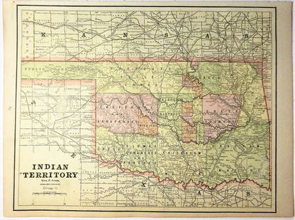


![Indian Territory Map by Donaldson, 1883 [181628] (1 of 1)](https://p1.liveauctioneers.com/2699/331495/178785757_1_x.jpg?height=282&quality=70&version=1717094933)


![Wah To Yah & The Taos Trail [181869] (1 of 5)](https://p1.liveauctioneers.com/2699/331494/178785312_1_x.jpg?height=282&quality=70&version=1717094654)


![British Plantation Map of the Americas [179303] (1 of 1)](https://p1.liveauctioneers.com/2699/331495/178785748_1_x.jpg?height=282&quality=70&version=1717094933)
![North America Map circa 1800s [179302] (1 of 1)](https://p1.liveauctioneers.com/2699/331495/178785793_1_x.jpg?height=282&quality=70&version=1717094933)
![Early French Map of East Coast & Canada [179301] (1 of 1)](https://p1.liveauctioneers.com/2699/331495/178785745_1_x.jpg?height=282&quality=70&version=1717094933)


![Jacob Monk 1853 Map of North America [173506] (1 of 11)](https://p1.liveauctioneers.com/2699/331495/178785775_1_x.jpg?height=282&quality=70&version=1717094933)

![Maps of Asia & India, c1800's (2) [180164] (1 of 2)](https://p1.liveauctioneers.com/2699/331495/178785787_1_x.jpg?height=282&quality=70&version=1717094933)
![1885 Cram Map of New Mexico [verso] Arizona -- New Mexico [verso] Arizona (1 of 2)](https://p1.liveauctioneers.com/5584/331526/178834526_1_x.jpg?height=282&quality=70&version=1717530687)


![Pyramid Lake Print Pair & 1885 NM & UT Territory Map [179398] (1 of 2)](https://p1.liveauctioneers.com/2699/331495/178785761_1_x.jpg?height=282&quality=70&version=1717094933)