Sold2017Asher & Adams: Map of Indian Territory, 1874Map: Hand Colored Map of Indian Terratory Maker: Asher & Adams Date: 1874 Size: Approx. 16x22 inches First edition of this large format railroad map of IndianTerritory, from Asher & Adams' Atlas of thSee Sold Price
Sold2018Asher & Adams: Antique Map of Indian Territory, 1874Title/Content of Map: 1874 Asher & Adams Indian Territory Map -- Asher & Adams Indian Territory and Texas North West Portion Date Printed: 1874, New York Cartographer: Asher & Adams Size: 16.3 x 23.2See Sold Price
Sold20191872 Asher and Adams Map of Arkansas and Western IndianTitle: 1872 Asher and Adams Map of Arkansas and Western Indian Territory -- Asher & Adams's Arkansas and Portion of Indian Territory Date: 1872 New York Cartographer: Asher & Adams Size: 15.8 x 22.8 iSee Sold Price
Sold2022Scarce Asher & Adams RR map of Florida, 1874Beautiful and scarce hand colored map of Florida done in the unique Asher & Adams style. All railroad lines—both existing and proposed—shown. Large 2-page map. Asher & Adams produced oneSee Sold Price
Sold20191872 Asher and Adams Geological Map of United States --Title: 1872 Asher and Adams Geological Map of United States -- Asher & Adams' Geological Map United States and Territories Date: 1872 New York Cartographer: Asher & Adams Size: 15.8 x 22.8 in. AdditioSee Sold Price
Sold20191872 Asher & Adams Map of Minnesota -- Asher & Adams'Title/Content of Map: 1872 Asher & Adams Map of Minnesota -- Asher & Adams' Minnesota Date: 1872, New York Cartographer: Asher & Adams Size: 22.4 x 16.1 in. This is a fantastic, very large double pageSee Sold Price
Sold2017Asher & Adams: Map of Pennsylvania & New Jersey, 1872Nicely colored Asher & Adams Pennsylvania and New Jersey. 1872. 15.75 x 22.75. Striking example of an Asher & Adams map which are often pale in hand coloring, or somewhat brittle. This one is nicely cSee Sold Price
Sold20181872 Asher & Adams Map of Michigan -- Asher & Adams'Title/Content of Map: 1872 Asher & Adams Map of Michigan -- Asher & Adams' Michigan Date: 1872, New York Cartographer: Asher & Adams Size: 22.2 x 16 in. This is a fantastic, very large double page mapSee Sold Price
Sold20181872 Asher & Adams Map of Europe -- Asher and Adams'Title/Content of Map: 1872 Asher & Adams Map of Europe -- Asher and Adams' Europe Date: 1872, New York Cartographer: Asher & Adams Size: 16 X 23 in. An attractive map of Europe showing rivers, lakes,See Sold Price
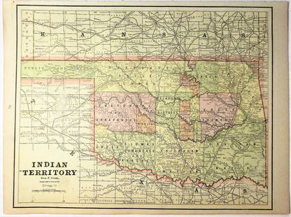
Sold2020Indian Territory 1891Title/Content of Map: Indian Territory 1891 Date Printed: 1891 Material/Medium: Paper Size: approx 10.5x14.5 inches Additional Info: Cram's Atlas of the World. Geo. F. Cram, Chicago Reserve: $20.00 SSee Sold Price
Sold2020Indian Territory 1897Title/Content of Map: Indian Territory 1897 Date Printed: 1897 Material/Medium: paper Size: approx. 11x 13.5 inches Additional Info: Cram's Universal Atlas Reserve: $30.00 Shipping: Domestic: Flat-ratSee Sold Price
Sold20162 19th Century MapsDESCRIPTION: Two 19th century maps. Includes: 1) Asher & Adams map of Florida with colored counties. Tears, abrasions, toning, spotting, split and hinged on reverse. Sealed under plastic against a foaSee Sold Price
Sold2021Government map of Indian TerritoriesHeading: (Indian Territory) Author: Dinsmore, A. F., Lowe, R.P., Naylor, William, Cartographers Title: Indian Territory. Department of The Interior General Land Office. Hon. Thomas H. Carter, CommissiSee Sold Price
Sold20181890 Census Office Map of Indian Territory and OklahomaTitle/Content of Map: 1890 Census Office Map of Indian Territory and Oklahoma -- Map of Indian Territory and Oklahoma Date: 1890, Washington Cartographer: General Land Office / Census Office Size: 22.See Sold Price
Sold202119th C. Map of Indian Territory & 20th C. Kachina**Originally Listed At $300** Map: "Map of Indian Territory Drawn and Engraved on Copper Plate Expressly for Johnson's Cyclopedia" - Volume IV New York - A.J. Johnson Company, ca. 1880 to 1894. FigureSee Sold Price
Sold2021Scarce map of Indian Territory, 1886Most likely the final map of Indian Territory produced by the Colton firm. Map is colored by Indian Nations, and shows a massive Cheyennes and Arapahoes Nation at the top. Over two dozen Native AmericSee Sold Price
Sold2020Map of Indian TerritoryTitle/Content of Map: Map of Indian Territory Date: 1899 Cartographer: U.S. GEOLOGICAL SURVEY Publisher: U.S.G.S. Size: 32.5Height - 29.5Width showing distribution of woodland. Compiled under the direSee Sold Price
Sold2021Map of Indian Territory & KansasMap of Indian Territory Combined with Map of Kansas on Verso Color Map Dated: 19th century Dimensions: 10 x 6 1/2" Condition Report Good. TextSee Sold Price
Sold2016Map of Indian Territory and Oklahoma, J. Bein 1890Title: Map of Indian Territory and Oklahoma Subject: Oklahoma Maker: J. Bein Date: 1890, New York Size: 22.5 x 29.5 inches Map of the Indian Territory showing areas ceded to various tribes, each withSee Sold Price
Sold20181883 General Land Office Map of Indian TerritoryTitle/Content of Map: 1883 General Land Office Map of Indian Territory -- Indian Territory Date Printed: 1883, Washington Cartographer: General Land Office Size: 12 x 16 in. This is a highly detailedSee Sold Price
Sold20221872 Asher and Adams Map of Florida -- Asher & Adams' FloridaTitle: 1872 Asher and Adams Map of Florida -- Asher & Adams' Florida Cartographer: Asher & Adams Year/Place: 1872 New York Dimensions: 15.8 x 22.8 in. Description: This is a superb, large map of FloriSee Sold Price
Sold20181872 Asher and Adams Map of Eastern Texas -- Asher &Reserve Reduced! Title/Content of Map: 1872 Asher and Adams Map of Eastern Texas -- Asher & Adams' Texas Date: 1872 New York Cartographer: Asher & Adams Size: 22.2 X 15.8 in. A very nice, large map ofSee Sold Price
Sold20181872 Asher and Adams Map of Florida -- Asher & Adams'Title/Content of Map: 1872 Asher and Adams Map of Florida -- Asher & Adams' Florida Date: 1872 New York Cartographer: Asher & Adams Size: 15.8 x 22.8 in. A very nice, large map of Florida. The major cSee Sold Price
Jun 02Schilb Antiquarian Rare Books1886 INDIANS 1ed Sa-Go-Ye-Wat-Ha Red Jacket Seneca Revolutionary War Hubbard$1
2 days LeftTrillium Antique Prints & Rare BooksCarey, pub. 1814 - Map of Hindostan or India$50(1 bid)
6 days LeftJasper52Central America Caribbean Gulf of Mexico chart Ports lighthouses LARGE 1918 map$45
May 14Fleischer's Auctions1755 Map Partie de l'Amerique Septentrionale, qui comprend Le Cours de L'Ohio...$200(3 bids)


![(2) Comanche Portraits by Lenny & Sawyers [Cabinet Card] (1 of 2)](https://p1.liveauctioneers.com/7226/322253/173251539_1_x.jpg?height=282&quality=70&version=1710004847)


