Sold202211th C. Taino Stone Pestle w/ Zemi HeadPre-Columbian, Caribbean Islands, Taino people, ca. 1000 to 1500 CE. A hand-carved stone pestle with a dense, egg-shaped body surmounted by the head of a mythological deity known as a zemi. It is possSee Sold Price
Sold202110 19th C Handwritten letters RE: Gen. H.G. ThomasWith notations. Denver CO 1884, (2) St. Paul MN 1865. Levenworth KS 1884. Washington D.C. 1882 St. Paul MN 1869, Walouina MN 1870, Denver CO 1884, Davids Island, NY 1868, Fort Snelling, 1870. Note thaSee Sold Price
Sold2017Antigua, Guadeloupe, Caribbean Map, Thomson, 1817TITLE/CONTENT OF MAP: 'Antigua. Guadaloupe. Mariegalante &c' A map of the French and British Leeward islands of Guadeloupe, Marie-Galante & Antigua DATE PRINTED: 1817 IMAGE SIZE: Approx 53.5 x 65.0cm,See Sold Price
Sold2022Antigua, Guadeloupe & Marie-Galante. West Indies Caribbean. THOMSON 1817 mapTITLE/CONTENT OF MAP: 'Antigua. Guadaloupe. Mariegalante &c' A map of the French and British Leeward islands of Guadeloupe, Marie-Galante & Antigua DATE PRINTED: Published in 1817 IMAGE SIZE: Approx 5See Sold Price
Sold20185 maps: West India Islands, Insulae Danicae...[Caribbean/Denmark/Central Europe] 5 Maps. Double-page. ++ West India Islands. 3 maps on 1 sheet: St. Christophers, St. Lucia, Nevis. “Engraved by Kirkwood & Son Edinburgh.” in margin. [C. 1810.]See Sold Price
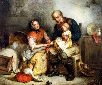
Sold2020Odilon Pierre (Haitian/Haiti) Countryside, CaribbeanOdilon Pierre (Haitian/Port-au-Prince, 1933-1988) At Work in Countryside, c.1980 Oil on canvas, 40 x 30 inches Framed dimensions: 42 x 32 inches Illustrated: Island on Fire, plate 132, page 164 I OdilSee Sold Price
Sold2023Antique 19th C German Prussian War Veterans MedalAntique 19th C German Prussian War Veterans Medal w/ Writings & Dated October 1, 1884. Condition: Generally Good.Dimensions: H-1.6" x W-1.4". Provenance: From a Long Island, NY Home.Please note the abSee Sold Price
Sold2016JOHN NESBITT (British, 1831-1904)Early Morning (View from the cave which inspired Robert Lewis Stevenson's Treasure Island.) sgn. and dated l.r. John Nesbitt 1884, o/c, 24 by 36 in., original gilt frame old label on reverse, writtenSee Sold Price
Sold2021GOOS, PIETER - Caribbean Islands Sea Chart 1666GOOS, Pieter (1616-1675) . Pascaert Vande Caribes Eylanden. Amsterdam: 1666. Engraved sea chart, period hand-colouring in outline. Sheet size: 21 1/2 x 25 inches. Minor age toning. Fine seventeenth ceSee Sold Price
Sold20221721 Senex Map of British Caribbean Islands -- A New Map of the English Empire in the Ocean ofTitle: 1721 Senex Map of British Caribbean Islands -- A New Map of the English Empire in the Ocean of America or West Indies Cartographer: J Senex Year/Place: 1721, London Dimensions: 20.1 X 23.8 in.See Sold Price
Sold2021ROBERT DE VAUGONDY, MAP OF CARIBBEAN, C. 1780Robert de Vaugondy (French, 1686-1766). "Partie de la Mer du Nord...." -circa 1780, engraving with hand coloring. Approx. 21" x 25.75" (sheet)See Sold Price
Sold20191613 Mercator/Hondius Map of Caribbean Islands -- CubaTitle/Content of Map: 1613 Mercator/Hondius Map of Caribbean Islands -- Cuba Insula [on sheet with] Hispaniola Insula [and] Insula Iamaica [and] Ins. S. Ioannis [and] Is. Margareta cum Confiniis Date:See Sold Price
Sold2021CHATELAIN MAP OF NORTH AMERICA & CARIBBEAN, C 1720Henry (Henri) Abraham Chatelain (Dutch, 1648-1743), "Carte Contenant le Royaume du Mexique et la Floride, Dressez sur les Meilleures Observations & sur les Memoires les Plus Nouveaux", engraving fromSee Sold Price
Sold2017Sanson: Antique Map of Caribbean Islands, 1656Map: Les Isles Antilles &c Cartographer: Sanson / Mariette Place & Date: Paris / 1656 Size: 21 1/2" x 15 1/2" Condition: outline and wash color; light overall age toning, heavier in the margins; someSee Sold Price
Sold2017Two Antique Maps Chili (sic) & Caribbean C. 16671) "Chili" (Chile), no publishers information, sight size 14.25" x 11.5", by Montanus A., C. 1670. (together with) 2) "Isles D'Amerique dites Caribes ov Cannibales et de Barlovento, by P. du Val d'abbSee Sold Price
Sold2023ANTIQUE EAST INDIA ISLANDS C 1840 MAPAntique East India Color Lithograph Map c. 1840 by a British Mapmaker. Purchased at Wattis Fine Art, Hong Kong. Professionally framed and matted. In frame measures 23.25"x22.25"x1.25" Weight 7 pds. PRSee Sold Price
Sold2023West Indies. Caribbean islands Antilles Gulf of Mexico Florida. THOMSON 1830 mapTitle: West Indies. Caribbean islands Antilles Gulf of Mexico Florida. THOMSON 1830 map Description: West Indies' by Drawn & engraved for John Thomson's "New General Atlas" (1830). Antique early 19thSee Sold Price
Sold2017de Fer: Antique Map of the Caribbean Islands, 1705Map: Les Isles de L'Amerique Connues Sous le Nom d'Antilles Cartographer: de Fer Place & Date: Paris / 1705 Size: 13 1/8" x 8 3/4" Condition: outline color; some nicks along edges of margins The fasciSee Sold Price
Sold2023British Caribbean Islands 1860's-1980's MH/Used GroupingBritish Caribbean Islands 1860's-1980's, a MH and used group on leaves and stocksheets, includes Bahamas Cayman Islands, Jamaica, Turks and Trinidad &Tobago, also Bahamas 1973 10 Dollar Sterling SilveSee Sold Price
Sold2023MAP ENGRAVING OF THE CARIBBEAN ISLANDS BY WM. FADEN.MAP ENGRAVING OF THE CARIBBEAN ISLANDS BY WM. FADEN. English, 19th Century. "Chart of the Antilles".See Sold Price
Sold20154 Caribbean Islands stamp albums, 20th centuryA group of 4 Caribbean Islands stamp albums, mostly 20th century. Including Jamaica, Trinidad, Taobago, Dominican Republic, Hati, French Guiana, Martinique, Honduras, Belize, British Virgin Islands, aSee Sold Price
Sold20155 Caribbean Islands stamp albums, 20th century.A group of 5 Caribbean Islands stamp albums, mostly 20th century. Including: Anguilla, Antigua, Bahamas, Barbados, Bermuda. Condition of books is good. they are not full.See Sold Price
Sold20213pc Vintage Caribbean Islands Chiquita Flower PlasticVintage souvenir dolls from Caribbean islands. Hard plastic body. Blinking eyes. Wearing colorful tropical floral print dresses. Measurements Large doll - 15"H. Medium doll - 13.5"H. Small St. ThomasSee Sold Price
Sold2016Caribbean Island Map, by Mount & Page, 1720 (rare &Spectacular sea chart of the Spanish Main to Puerto Rico, from Mount & Page's English Pilot, Fourth Book. Known as the most important English Atlas of Sea Chart covering the Mediterranean and North AmSee Sold Price
4 days LeftJasper521683 Sanson Map of the Caribbean -- Les Isles Antilles, &c Entre Lesquelles sont les Lucayes, et les$170
1818 AuctioneersA cased set of 16 Royal Mint Silver Proof Medallions, 1981 Marriage of the Prince of Wales & Lady£120(1 bid)
5 days LeftJasper52Pacific Islands. Polynesia Micronesia Melanesia. Fiji Caroline &c TIMES 1900 map$15
5 days LeftJasper52Pacific Islands. Polynesia Micronesia Melanesia. Fiji Caroline &c TIMES 1895 map$20
2 days LeftLotus International Auctions, LLCCoy Avon (C.A) Seward, Three Pines, dated 1929, etching,$90(3 bids)
1 day LeftAvra Art Auctions GEOFFREY STOUTE (20th c, Trinidad and Tobago) Damien Bay, Caribbean Fisherman$20(1 bid)


![5 maps: West India Islands, Insulae Danicae...: [Caribbean/Denmark/Central Europe] 5 Maps. Double-page. ++ West India Islands. 3 maps on 1 sheet: St. Christophers, St. Lucia, Nevis. “Engraved by Kirkwood & Son Edinburgh.” in margin. [C. 1810.]](https://p1.liveauctioneers.com/179/117971/60557767_1_x.jpg?height=310&quality=70&version=1520636872)


![1613 Mercator/Hondius Map of Caribbean Islands -- Cuba: Title/Content of Map: 1613 Mercator/Hondius Map of Caribbean Islands -- Cuba Insula [on sheet with] Hispaniola Insula [and] Insula Iamaica [and] Ins. S. Ioannis [and] Is. Margareta cum Confiniis Date:](https://p1.liveauctioneers.com/5584/144953/73284144_1_x.jpg?height=310&quality=70&version=1562102885)