Sold2021Nice 1862 map of Minnesota by MitchellMap of Minnesota at the time of the Dakota War of 1862. In August of that year, along the Minnesota River in the southwestern part of the state, the Dakota tribe began attacking settlers due to the haSee Sold Price
Sold20171862 Mitchell county map of Minnesota in near fineGreat chance to own an actual 150-year-old piece of history for a reasonable price. Beautiful and clean county map of Minnesota from Mitchell’s 1866 New General Atlas. When matted and framed, antiquSee Sold Price
Sold2017Mitchell: Antique Map of Minnesota, 18621862 Mitchell county map of Minnesota in near fine condition. Great chance to own an actual 150-year-old piece of history for a reasonable price. Beautiful and clean county map of Minnesota from MitchSee Sold Price
Sold20211876 Mitchell Map of Minnesota -- County Map ofTitle: 1876 Mitchell Map of Minnesota -- County Map of Minnesota Cartographer: S Mitchell Year / Place: 1876 Philadelphia Map Dimension (in.): 13.8 X 11.6 in. This is a very nice map of Minnesota, witSee Sold Price
Sold20221876 Mitchell Map of Minnesota -- County Map of MinnesotaTitle: 1876 Mitchell Map of Minnesota -- County Map of Minnesota Cartographer: S Mitchell Year / Place: 1876 Philadelphia Map Dimension (in.): 13.8 X 11.4 in. This is a very nice map of Minnesota, witSee Sold Price
Sold20181870 Mitchell Map of Minnesota -- County Map ofTitle/Content of Map: 1870 Mitchell Map of Minnesota -- County Map of Minnesota Date: 1870, Philadelphia Cartographer: S Mitchell Size: 13.8 x 11.5 in. This is nice county map of Minnesota. Great dealSee Sold Price
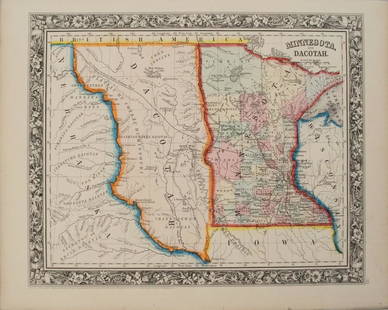
Sold20201860 Mitchell Map of Minnesota and the DakotasTitle/Content of Map: 1860 Mitchell Map of Minnesota and the Dakotas --Minnesota and Dacotah Date: 1860, Philadelphia Cartographer: S Mitchell Size: 10.6 X 13.3 in. This is a rather nice map of MinnesSee Sold Price
Sold20221862 Mitchell Map of Massachussetts, Connecticut andTitle: 1862 Mitchell Map of Massachussetts, Connecticut and Rhode Island -- County Map of Massachussetts, Connecticut and Rhode Island Cartographer: S Mitchell Year/Place: 1862 Philadelphia DimensionsSee Sold Price
Sold20191862 Mitchell Map of France, Spain, Portugal andTitle/Content of Map: 1862 Mitchell Map of France, Spain, Portugal and Helvetia -- Map of France, Spain and Portugal Cartographer: S Mitchell Size: 13.5 X 11 in. An attractive map of Southwestern EuroSee Sold Price
Sold2017Mitchell: Map of Persia, 18621862 Mitchell Map of Persia. 10.625 x 13.25. Map of Persia, Turkey in Asia, Afghanistan, Beloochistan. Very attractive example of S. A. Mitchell Jr.'s map of this region. Covers the modern day nationsSee Sold Price
Sold2017Mitchell: Map of France Spain Portugal Helvetia 18621862 Mitchell Map of France, Spain, Portugal and Helvetia. An attractive map of Southwestern Europe. Switzerland and Corsica are shown in inserts. Lots of topographical details along with towns and ciSee Sold Price
Sold2021Nice double-page map of New York, Mitchell 1860/66Title: Nice double-page map of New York, Mitchell 1860/66 Description: Impressive and colorful two-page map of the state of New York with inset maps of Buffalo, Rochester, Albany, and Troy. Hand colorSee Sold Price
Sold2022County Map of Minnesota from S. A. Mitchell, Jr. (1874)Fully hand colored map of Minnesota divided into counties. Towns, capitols, roads, rivers, lakes, railroads, and proposed railroads are labeled. A wagon road from Fort Ridgely westward toward the MissSee Sold Price
Sold20171860 Mitchell Mexico, Central America & West Indies Map1860 Map of Mexico, Central America and the West Indies, S. Augustus Mitchell. 13.25 x 21.13 inches. Authentic hand-colored antique map from Mitchell’s 1862 New General Atlas depicts Mexico, CentralSee Sold Price
Sold2017Mitchell: County Map of Texas, 1862County Map of Texas, S. Augustus Mitchell, 1862. 10.75 x 13.375 inches. Steel engraved map, with hand colored wash and outlines. Inset map of Galveston Bay, and Vicinity. Colored by county and territoSee Sold Price
Sold2022Nice map of Asia from S. A. Mitchell, Jr. – 1860sMap of Asia Showing its Political Divisions and also the Various Routes of Travel Between London & India, China & Japan, etc. Detailed map of Asia, colored by country. Full and original hand coloring.See Sold Price
Sold2017Mitchell: Antique Map of Minnesota, 1869Title/Content of Map: Minnesota by Mitchell Date Printed: 1869 Cartographer: Augustus S. Mitchell Material/Medium: Paper Size: 12" x 15" Hand colored engraved Map. From 'Mitchell's New General Atlas.'See Sold Price
Sold2020Early Civil War era map of AmericaNice example of A. J. Johnson's 1862 map of North America. Presents a fascinating snapshot of North America just after the outbreak of the American Civil War. States generally follow the 1861 configurSee Sold Price
Sold2019Map of Ore., Wash., Idaho & Montana, Mitchell 1860.Nice map of the northwestern states from Mitchell's 1864 New General Atlas published by S. Augustus Mitchell. One of the earliest maps to depict the new Territory of Montana (1864.) Maps from this perSee Sold Price
Sold20221862 RR map of Mass., Conn., Rhode Island, MitchellDetailed map of Southern New England, colored by counties and showing towns, railroads, rivers and other details. Shows the railway system in this region in the early years of the Civil War. One of thSee Sold Price
Sold2020Map of N. America, Mitchell 1860Great Mitchell “Map of North America Showing its Political Divisions and Recent Discoveries in the Polar Region.” This map came from Mitchell’s 1862 New General Atlas. Full vintage hand coloringSee Sold Price
Sold2018Mitchell: MinnesotaReserve Reduced! The beautifully detailed and colored county map of Minnesota from the 1870 edition of Mitchell's popular New General Atlas of the world. Framed by the decorative vine motif border typSee Sold Price
Sold20171878 Mitchell Map of New York and Brooklyn -- New YorkTitle/Content of Map: 1878 Mitchell Map of New York and Brooklyn -- New York and Brooklyn Date Printed: 1878, Philadelphia Cartographer: S Mitchell Size: 13.3 x 20.3 in. A very nice map of New York (MSee Sold Price
Sold20181852 Mitchell Map of Texas -- No.13 Map of the State ofTitle/Content of Map: 1852 Mitchell Map of Texas -- No.13 Map of the State of Texas Date: 1852, Philadelphia Cartographer: S Mitchell Size: 8 X 10.5 in. This is a very nice map of Texas from its earlySee Sold Price
Jun 14DuMouchellesWilliam H. Gamble (American, B. 1863) Hand Colored Engraving, Ca. 1863, "County Map of Michigan And$50(1 bid)
Jun 08Simpson Galleries, LLC.J.H. Young (1792-1870) AN AMERICAN FEDERAL PERIOD MAP, "Mitchell's Travellers Guide Through the$500
6 days LeftJasper521754 but early 1800s Delagrive Map of Paris Environs in Reduced Size -- Reduction des neuf feuilles$60
Featured6 days LeftJasper521884 Johnson Map of Washington Oregon and Idaho -- Johnson's Washington Oregon and Idaho$100
6 days LeftJasper521762 d'Anville Map of Ancient Greece -- Graeciae Antiquae Specimen Geographicum$80
6 days LeftJasper521881 Vuillemin World Map with French Colonies Shown -- Planisphere: Indiquant les Colonies Francises$30
6 days LeftJasper521852 Norwood Geological Map of Wisconsin and Minnesota -- Geological Map of Parts of Minnesota and$55
6 days LeftJasper521893 Civil War Map of Yorktown -- Secession Works at Yorktown [with] The Position of Yorktown with$55
6 days LeftJasper521852 Owen Geological Maps of the Pigeon River Minnesota -- (1) Geological Map Coast View and Section$45
5 days LeftRichard L. Edwards Auctioneering1862 (Civil War Era/Nice Condition) Indian Head Penny, 162 Years Old!$1


![1893 Civil War Map of Yorktown -- Secession Works at Yorktown [with] The Position of Yorktown with (1 of 1)](https://p1.liveauctioneers.com/5584/331064/178466378_1_x.jpg?height=282&quality=70&version=1716924723)


