Sold20221821 Chart of the World/Division of the EarthTwo maps within a single frame. (1) Chart of the World as Known to the Ancients on Mercator’s Scale, and (2) Divisions of the Earth among the Posterity of Noah. Great original full hand coloringSee Sold Price
Sold20191821 Chart of the World Map This is a mercator'sThis is a mercator's projection of North America by John Purdy, published Jan 1, 1821 by Richard Holmes Laurie, measures 40" wide by 26.5" tall.See Sold Price
Sold2017Doppelmayr / Homann: Celestial Chart of Earth's OrbitsMap: 1742 Doppelmayr / Homann Celestial Cart of the Orbits of Earth, Venus and Mercury -- Phaenomena Motuum Irregularium quos Planetae inferiores Venus et Mercurius ad annum Salutis MDCCX Date/Place:See Sold Price
Sold2023Blackie (Pub) C1875 Astronomy Celestial Chart. The Earth, Seasons, CometsLithograph Map Published 1837-1893 by Blackie & Son, London for "The Popular Encyclopedia; or, Conversations Lexicon" Centre fold as issued. Paper Size: 12.5 x 9.5 inch (30 x 24cm) Very minor toning,See Sold Price
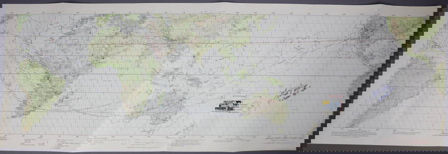
Sold2019Apollo 16 Earth Orbit Chart in Color.This original earth orbit chart dated February 15th 1972 for the Apollo 16 mission measures 13 1/2 inches tall by 41 inches long. Depicts earth revolutions one and two, the trans lunar injection burn,See Sold Price
Sold2023Fred Haise Signed Apollo 13 Earth Orbit ChartFirst Edition Apollo 13 Earth Orbit Chart measuring 41 1/2" x 13 1/2" that was prepared for NASA under the direction of the Department of Defense by the Aeronautical Chart and Information Center and dSee Sold Price
Sold2023Lunar Earth Side Chart LEC-1A beautiful Lunar Earth Side Chart LEC-1. This provisional chart is dated July 1968 and is compiled from the Lunar Orbiter 3 & 4 high resolution photographs. This is a very early and detailed LunaSee Sold Price
Sold20211960 Denoyer Geppert Science 12 Charts History of EarthDenoyer – Geppert picture History of Earth . There are twelve Science Charts in this series 1-Earth , 2- Earth as a sphere , 3- relationship of Earth and Sun , 4 - Maps , 5 - Time , 6 - Inside ESee Sold Price
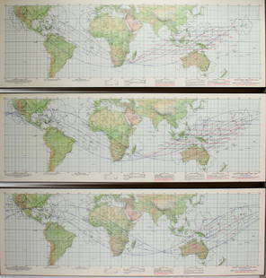
Sold20193 NASA APOLLO EARTH ORBIT CHARTS3 NASA APOLLO EARTH ORBIT CHARTS: 1st edition 26 November 1968. Prepared under the direction of the Department of Defense for NASA. Lithographed by ACIC 11/68. 41 1/2" XSee Sold Price
Sold2020Gemini GT-11 Mission Tracking ChartGemini mission GT-11 Earth Tracking Chart. This original and full sized map measures 11" x 32". The map is dated August 1966 and has the tracking coordinates on the back. This map has always been foldSee Sold Price
Sold2023Apollo 10 Earth Orbit Tracking ChartA vintage and original Apollo 10 Earth Orbit Tracking Chart from NASA. This is a First Edition sheet 2 of 3 and dated 16 April 1969. It measures 13 1/2" x 41 1/2" and is in very good condition with miSee Sold Price
Sold2023Apollo 9 Earth Orbit Tracking ChartAn original Apollo 9 Earth Orbit Tracking Chart. This first edition chart dated January 31, 1969 measures 13 ½” x 41 ½” and is in very good condition with light edge wear. This cSee Sold Price
Sold2021Scarce Genealogical h/c chart of Anglo-Saxons, 1821Large format, two-page foldout showing the historical and chronological map of the Church. Historical and Chronological Map of the Church from the Ascension of Jesus Christ to the Year 1821, with a LiSee Sold Price
Sold2021Scarce Genealogical h/c chart of Anglo-Saxons, 1821Large format, two-page foldout showing the genealogical, historical and chronological story of the Anglo-Saxons up to the Norman Invasion in 1066. Presented in blocks of period hand-coloring to make tSee Sold Price
Sold2023Lot of (2). Orlando Furioso Di Lodovico Ariosto copyright 1821. History of the earth and animatedLot of (2). Orlando Furioso Di Lodovico Ariosto copyright 1821. History of the earth and animated nature by Oliver Goldsmith copyright 1795See Sold Price
Sold2023Neil, Samuel 1897 Astronomy Chart. Revolution of the Earth round the SunWoodblock Published 1897, London for "The Home Teacher. A Cyclopededia of Self Instruction" Edited by Samuel Neil. Centre fold as published. Paper Size: 14 x 10.5 inch (36 x 27cm) Good ConditionSee Sold Price
Sold2021Scarce h/c timeline chart of U. S., 1821200-year-old, hand colored antique and rare timeline of the history of the United States, from the first settlement in Jamestown to James Monroe's inauguration in 1821. Chronological and Statistical MSee Sold Price
Sold2021Scarce h/c timeline chart of U. S., 1821Title: Scarce h/c timeline chart of U. S., 1821 Description: 200-year-old, hand colored antique and rare timeline of the history of the United States, from the first settlement in Jamestown to James MSee Sold Price
Sold2021Scarce Genealogical h/c chart of Sacred History, 1821Large format, two-page foldout of Sacred History showing the Accession of Saul to the Birth of Jesus Christ. Presented in blocks of period hand-coloring to make the information clear and easily undersSee Sold Price
Sold2021Scarce Genealogical h/c chart of Empires & States, 1821Large format, two-page foldout showing the Revolution of Empires and States from Noah leaving the ark after the Deluge to the French Revolution in 1789. Presented in blocks of period hand-coloring toSee Sold Price
Sold2018Astronomy, Celestial 1821 Lot of 6 Star ChartsAquatints Published 1821, London for "The Wonders of the Heavens Displayed, in Twenty Lectures" by Richard Phillips. Paper Size: Up to 10.5 x 8.5 inch (27 x20cm) Good conditionSee Sold Price
Sold2016CARLOS CAPELAN (Uruguayan, b. 1948)Three Indian ink, red ochre and earth on Baltic Sea nautical charts; All signed; 44" x 30" (sheet, each); Provenance: Private Collection, New York CitySee Sold Price
Sold20181874 McNally Chart of World Mountain Ranges and RainTitle/Content of Map: 1874 McNally Chart of World Mountain Ranges and Rain Fall Patters -- Chart of the Highlands & Lowlands of the Earth, Principal Volcanoes and Isothermal Lines Date Printed: 1874 cSee Sold Price
Sold20231821 Woodbridge Thematic World Map -- Moral and Political Chart Of The Inhabited World ...Title: 1821 Woodbridge Thematic World Map -- Moral and Political Chart Of The Inhabited World ... Cartographer: W. Woodbridge Year / Place: 1831, Hartford Map Dimension (in.): 8.2 X 10.8 in. This is aSee Sold Price
3 days LeftC & T Auctioneers and Valuers LtdHellraiser III Hell on Earth Special Effects Pinhead Prop£200
JG AutographsBuckminster Fuller - Architect, Inventor, Futurist - Autographed Spaceship Earth Sky-Ocean Map Model$75(7 bids)
4 days LeftFreeman's | HindmanDoug Hyde (Nez Perce/Chippewa/Assiniboine, b. 1946) Mother Earth Brings the Rain, 1980$500
May 18Rich Penn AuctionsOptical Charts & Examining Tools (8), the Emmetropic Eye, (2) J.K.O. Co. charts & 5 early 1900's$50
May 16Eldred'sFREDERIC SCHILLER COZZENS (New York, 1846-1928), Signal flag chart, Lithograph on paper, 14" x$100
Jun 02Taylor & HarrisGeorgian Thomas & John Settle English Repousse Sterling Silver Coffee Pot 1821$1,000(1 bid)
5 days LeftHunt and Peck Estate Services, Inc.Chart Of The World According To Mercators Projection Showing Tracks & Discoveries Of Capt. Cook$140