Sold20211829 Wallis Map of Cornwall -- CornwallTitle: 1829 Wallis Map of Cornwall -- Cornwall Cartographer: J Wallis Year / Place: 1829 c., London Map Dimension (in.): 7.8 X 10.3 in. This is a very nice map of Cornwall, the county in extreme southSee Sold Price
Sold20221840 Moule Map of Cornwall -- CornwallTitle: 1840 Moule Map of Cornwall -- Cornwall Cartographer: T Moule Date/Place: 1840, London Dimensions: 7.9 X 10.1 in. Description: This is a very nice map of Cornwall, the county in extreme southwesSee Sold Price
Sold2022Cornwall.- Speed (John) Cornwall, engraved map, [c. 1676].Speed (John) Cornwall, county map with inset view of Launceston, vignettes with stone monuments, armorial cartouche, ships and sea monsters, with coats-of-arms below, engraved map by Jodocus Hondius wSee Sold Price
Sold2018CORNWALL. Antique county map. Railways. Bodmin Moor.TITLE/CONTENT OF MAP: 'Cornwall; Inset map of Scilly Islands' DATE: 1863 IMAGE SIZE: Approx 32.0 x 43.5cm, 12.75 x 17 inches (Large) TYPE: Antique map with original outline colour CONDITION: Good; suiSee Sold Price
Sold2021Wilkes, John 1802 Map. CornwallCopper Engraved Map Published 1796-1828 London for "Encyclopaedia Londinensis, or universal dictionary of arts, sciences and literature" by John Wilkes et al. Paper Size: 10.5 x 8.5 inch (27 x 22cm) WSee Sold Price
Sold2022Moule, Thomas C1845 British Map. CornwallSteel Engraved Map Published C1845, London for "A Complete and Universal English Dictionary" by the Rev. James Barclay et al. Maps by Thomas Moule. Paper Size: 10.5 x 8 inch (27 x 21cm) Very minor tonSee Sold Price
Sold2020Moule, Thomas C1850 British Map. CornwallSteel Engraved Map Published C1850 "A Complete and Universal English Dictionary" by the Rev. James Barclay et al. Maps by Thomas Moule. Paper Size: 10.5 x 8 inch (27 x 21cm) Good ConditionSee Sold Price
Sold2020Moule, Thomas C1838 British Map. CornwallSteel Engraved Map Published C1838 for "A Complete and Universal English Dictionary" by the Rev. James Barclay et al. Maps by Thomas Moule. Paper Size: 10.5 x 8 inch (27 x 21cm) A couple of tiny toneSee Sold Price
Sold2020Moule, Thomas C1838 British Map. CornwallSteel Engraved Map Published C1838 for "A Complete and Universal English Dictionary" by the Rev. James Barclay et al. Maps by Thomas Moule. Paper Size: 10.5 x 8 inch (27 x 21cm) Good ConditionSee Sold Price
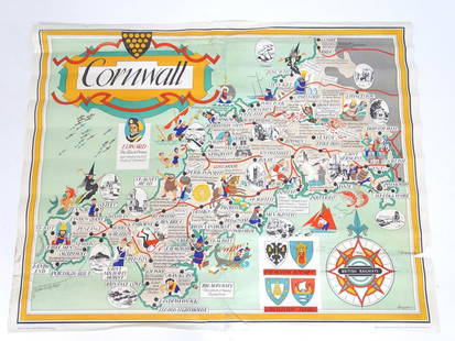
Sold2021A British Railways lithographic poster, Cornwall,A British Railways lithographic poster, Cornwall, Depicting an illustrative map of Cornwall designed by William Bowyer (1926-2015). Printed by Jordison & Co. Ltd. London and Middlesbrough. Approx. 39See Sold Price
Sold2017Two(2) Early Hand Colored MapsTwo(2) framed hand colored maps. Cornwall and Dorsetshyre; 15.5in. X 20.25in.See Sold Price
Sold20231806 Hand Colored Map of Cornwall, John Cary1806 Map of Cornwall, England by John Cary (1755-1835). Copper plate map titled "A Map of Cornwall from the Best Authorities". Detailed hand colored map with Scilly Islands inset. Good condition, setSee Sold Price
Sold2020Bowles, Carrington 1782 Road Map. Devon, CornwallShowing Dorchester, Axminster, Bridport, Falmouth, Truro etc. Copper Engraved Map Published 1782, London for "Bowles's Post-chaise Companion, Or, Travellers Directory Through England and Wales" by CarSee Sold Price
Sold201819th C Linen Manuscript Map Tuckingmill Cornwall19th century manuscript linen map on an area referred to as Tuckingmill in the County of Cornwall. Very Good, Measures 9 x 7”. Please note that this lot has a confidential reserve. When you leave aSee Sold Price
Sold2018Cruchley, George C1850 Folding HC Map of Cornwall"Cruchley's County Map of Cornwall Showing all the Railways and Names of Stations" Scarce folding map by George Cruchley, Published Gall & Inglis. Linen backed. Paper Size: 22.5 x 21 inch (57 x 53cm)See Sold Price
Sold2015Willem Blaeu, Cornubia sive Cornwallia, Amsterdam:Willem Blaeu, Cornubia sive Cornwallia, Amsterdam: c.1640, Handcolored engraved map of Cornwall, coats-of-arms, galleons, foxing, and water staining, center creaseSee Sold Price
Sold2023The County Of Cornwall Colored Map LithographColored map Lithograph reading The County of Cornwall from best authorities. Depicting the English county with the names of the towns and cities with names of different bays. No frame. Approximately 1See Sold Price
Sold2019Philip, George C1895 Maps of Devon, Cornwall Dorset (3)Lithograph Maps Published C1895 by George Philip & Son, London for "Phillips' Atlas of the British Isles" Centre fold as issued. Paper Size: 14.5 x 10 inch (37 x 25cm) Closed centre fold split on CornSee Sold Price
Sold2018Very Rare Rockingham-Glazed Anna Pottery Pig BottleVery Rare Rockingham-Glazed Anna Pottery Pig Bottle with Incised Railroad Map, Wallace and Cornwall Kirkpatrick, Anna, IL, circa 1880, molded in the form of a reclining pig with incised snout and hoovSee Sold Price
Sold2021TWO ENGLISH MAPScolored engravings; depicting maps of Devonshire and Cornwall; together in one frame; each 7 1/4 x 4 3/4 inches sight; 13 3/4 x 17 1/2 inches frame;See Sold Price
Sold2022Map of the Town of Cornwall, Connecticut, Circa 1854Map of the Town of Cornwall, Connecticutcirca 1854marked "Map of the Town of Cornwall, Litchfield County, Connecticut, Surveyed & Drawn by L. Fagan, Published by Richard Clark, 42, Moyamensing RoSee Sold Price
Sold2016Antique Map, A New Map of the County of CornwallC. Smith (British, 19th century), "A New Map of the County of Cornwall Divided into Hundreds," 1804, hand-colored copper engraved map, published in Smith's New English Atlas, with the Jones & Smith scSee Sold Price
Sold2018England & Wales (Section 6) [Cornwall And SouthwestTitle/Content of Map: England & Wales (Section 6) [Cornwall And Southwest England] Date Printed: 1890 Cartographer: BARTHOLOMEW, JOHN & CO. Size: 11.5X16.25 "By J. Bartholomew, F.R.G.S." 17 Two insetsSee Sold Price
Sold2022Cornwall.- Borlase (William) Antiquities, historical and monumental, of the county of Cornwall,Cornwall.- Borlase (William) Antiquities, historical and monumental, of the county of Cornwall, second edition, 2 engraved maps, of which 1 folding, 25 engraved plates, of which 1 folding, damp-stainiSee Sold Price
May 22Thomaston Place Auction GalleriesEARLY 17TH C. ELIZABETHAN ENGRAVED MAP OF CORNWALL BY WILLIAM KIP AFTER WILLIAM SAXTON$150
5 days LeftJasper52Carte de la Scandinavie… Scandinavia Sweden Norway Denmark. LAPIE 1830 old map$45
Featured5 days LeftJasper52Carte de l'Europe… l'invasion des barbares. Barbarian invasions. LAPIE 1830 map$50
5 days LeftJasper52Watercolour Nautical Marine Cornwall Rocky Cliff Shoreline By A E Newling C1920$1,000
5 days LeftJasper52Expressionist Oil Painting St Ives Smeaton's Pier Beach Cornwall By Linda Weir$3,400


![Cornwall.- Speed (John) Cornwall, engraved map, [c. 1676].: Speed (John) Cornwall, county map with inset view of Launceston, vignettes with stone monuments, armorial cartouche, ships and sea monsters, with coats-of-arms below, engraved map by Jodocus Hondius w](https://p1.liveauctioneers.com/5458/268810/140590910_1_x.jpg?height=310&quality=70&version=1668514381)


![England & Wales (Section 6) [Cornwall And Southwest: Title/Content of Map: England & Wales (Section 6) [Cornwall And Southwest England] Date Printed: 1890 Cartographer: BARTHOLOMEW, JOHN & CO. Size: 11.5X16.25 "By J. Bartholomew, F.R.G.S." 17 Two insets](https://p1.liveauctioneers.com/5584/121580/61869452_1_x.jpg?height=310&quality=70&version=1525825976)


