Sold20241837 Afghanistan and N. Pakistan. By A. PerrotTitle: 1837 Afghanistan and N. Pakistan. By A. Perrot Date/Period: 1837 Materials: Hand-colored steel engraving Size: 7 x 10 3/4” This is a map of Afghanistan and current northern Pakistan fromSee Sold Price
Sold20231837. Algeria Map by A PerrotTitle: 1837. Algeria Map by A Perrot Date/Period: 1837 Materials: Hand-colored steel engraving Size: 7 x 10 3/4” This is a map of Algeria from 1837, created by Aristide Perrot. It was publishedSee Sold Price
Sold20241837 Egypt Map by A. PerrotTitle: 1837 Egypt Map by A. Perrot Date/Period: 1837 Materials: Hand-colored steel engraving Size: 7 x 10 3/4” This is an 1837 map of Egypt by Aristide Perrot. It was published in Paris and is pSee Sold Price
Sold20241837 Egypt Map by A. PerrotTitle: 1837 Egypt Map by A. Perrot Date/Period: 1837 Materials: Hand-colored steel engraving Size: 7 x 10 3/4” This is an 1837 map of Egypt by Aristide Perrot. It was published in Paris and is pSee Sold Price
Sold2023BOKHARA KABUL & BALUCHISTAN. Afghanistan Khorassan Sinde Pakistan. SDUK 1846 mapTitle: BOKHARA KABUL & BALUCHISTAN. Afghanistan Khorassan Sinde Pakistan. SDUK 1846 map Description: BOKHARA, KABOOL AND BELOOCHISTAN.' by Engraved by J & C Walker (1846). Antique steel engraved map,See Sold Price
Sold20241837 Map of Belgium By A. PerrotTitle: 1837 Map of Belgium By A. Perrot Date/Period: 1837 Materials: Copperplate engraved Size: 7 x 10 3/4” This is a map of Belgium from 1837, created by Aristide Perrot. Published in Paris, itSee Sold Price
Sold2015A. M. Perrot. Map of Indochina. 1837.Print of hand colored steel engraving titled Indo-Chine“.Author A. M. Perrot.Engraved by unknown.From Dictionnaire universel Geographie moderne, description physique, politique et historique de tousSee Sold Price
Sold2015A. M. Perrot. Map of Mexico. 1837.Print of hand colored steel engraving titled Mexique“.Author A. M. Perrot.Engraved by unknown.From Dictionnaire universel Geographie moderne, description physique, politique et historique de tous leSee Sold Price
Sold2015A. M. Perrot. Map of Peru. 1837.Print of hand colored steel engraving titled Perou“.Author A. M. Perrot.Engraved by unknown.From Dictionnaire universel Geographie moderne, description physique, politique et historique de tous lesSee Sold Price
Sold2015A. M. Perrot. Map of Egypt. 1837.Print of hand colored steel engraving titled Egypte“.Author A. M. Perrot.Engraved by unknown.From Dictionnaire universel Geographie moderne, description physique, politique et historique de tous lesSee Sold Price
Sold2015A. M. Perrot. Map of Colombia. 1837.Print of hand colored steel engraving titled Colombie“.Author A. M. Perrot.Engraved by unknown.From Dictionnaire universel Geographie moderne, description physique, politique et historique de tous lSee Sold Price
Sold2015A. M. Perrot. Map of Persia. 1837.A. M. Perrot. Map of Persia. 1837.Print of hand colored steel engraving titled Perse“.Author A. M. Perrot.Engraved by unknown.From Dictionnaire universel Geographie moderne, description physique, poSee Sold Price
Sold2023CABOOL PUNJAB & BELOOCHISTAN Pakistan Afghanistan Lahore. RAPKIN/TALLIS 1851 mapTITLE/CONTENT OF MAP: 'Cabool, The Punjab and Beloochistan' The map covers modern Pakistan, Afghanistan, and part of India. Vignettes: Boats on the Indus; Sultan Mahmoud's Minars and Fortress - GhuzneSee Sold Price
Sold2021CABOOL PUNJAB & BELOOCHISTAN. Pakistan AfghanistanTITLE/CONTENT OF MAP: 'Cabool, The Punjab and Beloochistan' The map covers modern Pakistan, Afghanistan, and part of India. Vignettes: Boats on the Indus; Sultan Mahmoud's Minars and Fortress - GhuzneSee Sold Price
Sold2017Weller: Map of Afghanistan & Beloochistan, 1863Map: 'Afghanistan, Beloochistan, Pakistan. Kabul Karachi Quetta.' Date Printed: 1863 Image Size: Approx 43.5 x 31.0cm, 17.25 x 12.25 inches (Large) Type: Antique map with original outline colour CondiSee Sold Price
Sold20241837 India, British Empire Map, By A. PerrotTitle: 1837 India, British Empire Map, By A. Perrot Date/Period: 1837 Materials: Hand-colored steel engraving Size: 7 x 10 3/4” This is a map of India during the British Empire period, created iSee Sold Price
Sold2015A. M. Perrot. Map of Chinese Empire. 1837.Print of hand colored steel engraving titled Empire Chinois“.Author A. M. Perrot.Engraved by unknown.From Dictionnaire universel Geographie moderne, description physique, politique et historique deSee Sold Price
Sold2015A. M. Perrot. Map of United States. 1837.Print of hand colored steel engraving titled Etats-Unis“.Author A. M. Perrot.Engraved by unknown.From Dictionnaire universel Geographie moderne, description physique, politique et historique de tousSee Sold Price
Sold2015A. M. Perrot. Map of the World. 1837.Print of hand colored steel engraving titled Mappe - Monde“.Author A. M. Perrot.Engraved by unknown.From Dictionnaire universel Geographie moderne, description physique, politique et historique de tSee Sold Price
Sold2015A. M. Perrot. Map of North America. 1837.Print of hand colored steel engraving titled Amerique Septentrionale“.Author A. M. Perrot.Engraved by unknown.From Dictionnaire universel Geographie moderne, description physique, politique et histoSee Sold Price
Sold2020BLAEU, WILLEM. Persia Sive Sophorum Regnum.BLAEU, WILLEM. Persia Sive Sophorum Regnum. Hand-colored double-page engraved map of modern-day Afghanistan, Pakistan, Iraq, Iran, and the Persian Gulf region. 15½x21 inches sheet size, top and bSee Sold Price
Sold20241837 Arabian Peninsula. By A. PerrotTitle: 1837 Arabian Peninsula. By A. Perrot Date/Period: 1837 Materials: Hand-colored steel engraving Size: 7 x 10 3/4? This is a 1837 map of the Arabian Peninsula by Aristide Perrot. It was publishedSee Sold Price
Sold2020Ancient western India. Today’s Afghanistan & PakistanTitle: Ancient western India. Today’s Afghanistan & Pakistan Description: Map by Emanuel Bowen, published by John Harris in 'Navigantium Atque Itinerantium Bibliotheca' or a Complete Collection of VSee Sold Price
Sold20241837 Map of North Western Italy with Sardinia By A. PerrotTitle: 1837 Map of North Western Italy with Sardinia By A. Perrot Date/Period: 1837 Materials: Copperplate engraved Size: 7 x 10 3/4” This is a map of North western Italy with Sardinia from 1837See Sold Price
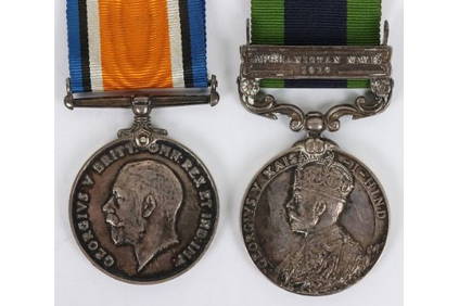
C & T Auctioneers and Valuers LtdCampaign Medal Pair for Service in the Great War and the Northwest Frontier with the Royal Army Medi£50(1 bid)
6 days LeftSchilb Antiquarian Rare Books1901 Treasury of Pashto Ganj e Pakhtu Roos Keppel Afghanistan Folklore Pakistan$24(2 bids)
Jul 02Rob Michiels AuctionsA varied collection of jewellery and accessories, Afghanistan, India, Pakistan, and Yemen, 19th C.€300
3 days LeftCoronari AuctionsTwo handcoloured engraved maps: N. Visscher (1618-1709): 'Magnae Brittanniae' (1695) and Homann€120
1 day LeftJasper521806 Cary Map of India, Pakistan and Sri Lanka -- A New Map of Hindoostan, from the Latest$70
5 days LeftArader GalleriesLand Grant for the Chemung River in Northumberland County New York State$800
Jun 26Templum Fine Art AuctionsHistory of Colonial Mexico - Viceroyalty of New Spain - Large and Very Rare Exceptional Map of New€1,000
1 day LeftJasper521788 Gravius World Map -- Kaart van de Geheele Wereld na de Alderlaatste Ontdekkingen$130
5 days LeftTrillium Antique Prints & Rare BooksPrevost - Volume 16 with 31 Maps & Engravings (Including Map or Australia)$210(2 bids)
BonhamsPALLAS (PETER SIMON) Travels Through the Southern Provinces of The Russian Empire in the years 1...£50(5 bids)