Sold2023Williamson, Lieut. R. S. 1856 Map. California - Tejon Pass & Canada de las Uvas"Geological Map of the Tejon Pass & Canada de las Uvas and the Vicinity. Including the Pass of San Francisco & Williamsons Pass"Lithograph Map Published 1853-61, Washington for "Reports of explorationSee Sold Price
Sold20211853 Geological Map of Passes by St. Gabriel Mountains,Title: 1853 Geological Map of Passes by St. Gabriel Mountains, CA -- Geological Map of the Tejon Pass & Canada de las Unas Including the Pass of San Franciscoquito & Williamson's Pass Cartographer: WSee Sold Price
Sold20211853 Williamson Map of California's Tejon Pass Area --Title: 1853 Williamson Map of California's Tejon Pass Area -- Map of the Passes in the Sierra Nevada from Walker's Pass to the Coast Range under the direction of the Hon. Jefferson Davis, Secretary ofSee Sold Price
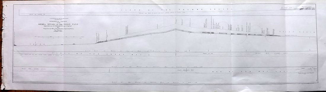
Sold2023Williamson, Lieut. R. S. 1856 LG Chart. California - Sierra Nevada & Tejon Pass"Goelogical Section of the Sierra Nevada at the Tejon Pass" by R. S. Williamson. Lithograph Map Published 1853-61, Washington for "Reports of explorations and surveys, to ascertain the most practicablSee Sold Price
Sold2023Williamson, Lieut. R. S. 1856 LG Chart. California - Sierra Nevada, Tulare Valley etc"Geological Section along the Tejon Ravine from the Tulare Valley and the Tejon Depot Camp to Taheechaypah Prairie" "Geological Section of the Sierra Nevada at the Canada de las Uvas" by William P. BlSee Sold Price
Sold2023Williamson, Lieut. R. S. 1856 LG Chart. California - Bernadino Pass, San Bernardino, Colorado Desert"Geological Sections of the Bernadino Pass" Lithograph Map Published 1853-61, Washington for "Reports of explorations and surveys, to ascertain the most practicable and economical route for a railroadSee Sold Price
Sold2020Mitchell Map of Western U.S.*** START PRICE IS THE RESERVE *** [America] MITCHELL, Samuel Augustus (1792-1868). A New Map of Texas, Oregon and California with the Regions Adjoining. Engraving with original hand color, with origiSee Sold Price
Sold2021A New Map of Texas, Oregon and California"A New Map of Texas, Oregon and California with the Regions Adjoining" by S. Augustus Mitchell, engraving with hand-coloring, 1st edition, published Philadelphia, 1846; framed together with original bSee Sold Price
Sold2023TWO ANTIQUE MAPS OF CHINA.Two antique maps of China, including Chinae by Abraham Ortelius, 1595, image 14.25” x 18.25”, with map of Eastern Asia, Le table de la region orientale, image 10” x 13.5”.See Sold Price
Sold2024MAP, USA & Mexico, Auto Club of SoCalSouthwestern United States & Mexico. Automobile Club of Southern California, A Map of Exploration in the Spanish Southwest 1528-1793, from Supplement to Touring Topics, Volume Twenty-Four, Number One,See Sold Price
Sold2022MITCHELL, S. AUGUSTUS. A New Map of Texas, Oregon and California.MITCHELL, S. AUGUSTUS. A New Map of Texas, Oregon and California. Engraved pocket map of the American territories west of the Mississippi River. 22¾x21 inches overall, ample margins; strong origiSee Sold Price
Sold2023MITCHELL'S NEW MAP of TEXAS, OREGON & CALIFORNIA1846 Philadelphia, S. Augustus Mitchell. hardcover leather bound. 5 1/4 x 3 1/4 inches. Map unfolded 22 x 20 1/2 inches and presented in a custom frame 23 1/2 x 22 inches (overall)See Sold Price
Sold2021A COLONIAL MAP, "Carte de la Louisiane et du Cours duA COLONIAL MAP, "Carte de la Louisiane et du Cours du Mississipi," PARIS, JUNE 1718, hand colored engraving on paper, "Dressée sur un grand nombre de Mémoires entr'autres sur ceux de Mr. le Maire paSee Sold Price
Sold2024De Fer Map of the Mississippi RiverDE FER, Nicolas (1646-1720). Partie Meridionale de la Riviere de Missipi, et ses environs, dans l'Amerique Septentrionale. Mis au jour par N. de Fer. Geographe de sa Majeste Catolique 1718. Engraved mSee Sold Price
Sold2024De Wit - Map of Persia, Arabaia, Armenia, TurkeyThis remarkable folio engraving from a composite atlas of maps from Frederick De Wit. It was published in Amsterdam after 1688. It features original hand-coloring. De Wit published composite atlases uSee Sold Price
Sold2021San Antonio Conservation Society 1926 MapVintage 1926 San Antonio Conservation Society historic guide map of San Antonio de Bexar, drawn by Emily Edwards, portrays San Antonio from 1682-1721, unframed 39 x 28"; Provenance: A Schertz, TX EsSee Sold Price
Sold2024Texaco Travel Service Advertising Map Rack with 15 MapsMaps from US and Canada. The front sign has some fading. It is 9" x 12" x 4"See Sold Price
Sold2022Conde, Calvo & Maverick - Mexico City, 1830 - Plano general de la Ciudad de MexicoGARCIA CONDE, Diego (1760-1822) - CALVO, Rafael Maria - MAVERICK, Peter (1780-1831). Plano general de la Ciudad de Mexico... Engraved map with original hand color. New York: 1830.20" x 22" sheet. ProvSee Sold Price
Sold2024Petrus Plancius, Engraved World MapOrbis Terrarum Typus de Integro Multis in Locis Emendatus. Petrus Plancius (1552-1622). Copper-plate engraving with original hand color in full. Amsterdam, 1594. Some stains, creases, folds. Sight sizSee Sold Price
Sold2015De Bry (Theodore) - Descriptio Hydrographicathe 2-sheet map of Africa and Asia, from the east coast of Brazil to Japan, charting the first Dutch voyage to the East Indies by Houtman, large titlecartouche upper centre of right sheet, ships, compSee Sold Price
Sold2017DIDIER ROBERT DE VAUGONDY (FRENCH, 1688-1766) ATLASDIDIER ROBERT DE VAUGONDY (FRENCH, 1688-1766) ATLAS VOLUME "Atlas Universel", 1757, folio, leather boards, engraved title page, 106 hand-colored double-page maps, missing numbers 24 and 40. With proteSee Sold Price
Sold2022Petrus Kaerius and Abraham Ortelius, Two Vintage MapsPETRUS KAERIUS and ABRAHAM ORTELIUS (Flemish, 1571-1646), and (Belgian, 1527-1598), Orbis Terrarum Typus De Integro Multis In Locis Emendatus auctore Petro Kaerio anno 1607, and Indiae Orientalis InsuSee Sold Price
Sold2021GEORGE BURGESS 1853 CALIFORNIA GOLD MINING OPERATIONMokelunme River watercolor 10 x 14 inches. signed and dated. framed. 16 x 20 inches (overall) * Note: During the California Gold Rush, the Mokelumne was a major gold-producing stream. The first personSee Sold Price
Sold2022Cundo Bermudez "Nina de Las Flores" Oil PaintingCundo Bermudez (Cuban: 1914 - 2008) portrait oil painting on canvas of a girl blowing petals off a flower. Circa: 1956. Hand signed to lower right. Measures: 23" W x 29-1/4" H. Frame: 31-1/4" W x 37-1See Sold Price
2 days LeftChampagne AuctionsKent Kane, Elisha - Arctic Exploration, The second Grinnell Expedition, 1st edition - 1856CA$120
Oct 06Schilb Antiquarian Rare Books1897 Alaska & Klondike 1ed Gold Fields Canada INDIANS Cannibalism Slavery MAPS$52(4 bids)
Nov 03Modern JewelryNEW 14K YELLOW GOLD CALIFORNIA STATE MAP PENDANT 14K YELLOW GOLD NEW CALIFORNIA STATE MAP PENDANT$335
3 days LeftForum AuctionsWorld.- Blaeu (Johannes) Nova et Accuratissima Totius Terrarum Orbis Tabula Auctore Joanne Blaeu,£7,000
7 days LeftGrace Auction & Estate Gallery LLCPlan de Paris Map 1927 by Ilonka Karasz, Washington Square Bookshop$20
5 days LeftTrillium Antique Prints & Rare BooksSanson - Map of the World (L'Hydrographie ou Description de l'Eau?)$75
3 days LeftForum AuctionsNapoleon family copy.- Mémoires pour servir a l'Histoire de France en 1815, first edition, from the£650
Oct 12JM Hobby Supply and Railroad Artifact AuctionsNorth Pennsylvania RR Prospectus-1853$110(3 bids)
3 days LeftBrunk AuctionsSpanish Colonial Mexican Carved and Polychrome Cruz de las Animas$750(4 bids)
Oct 13Cain Modern AuctionsSilver Ice Tongs by Emilia Castillo from -The Mokey-Collection, Mexico 1980s$150


![Mitchell Map of Western U.S.: *** START PRICE IS THE RESERVE *** [America] MITCHELL, Samuel Augustus (1792-1868). A New Map of Texas, Oregon and California with the Regions Adjoining. Engraving with original hand color, with origi](https://p1.liveauctioneers.com/1968/163248/82424595_1_x.jpg?height=310&quality=70&version=1583340284)


![[MAPS] DOUBLE-PAGE. LOT OF 4 SOLD TOGETHER (1 of 4)](https://p1.liveauctioneers.com/8124/343618/186530168_1_x.jpg?height=282&quality=70&version=1726178725)


![[CANADA REPORTS] LOT OF 2 VOLUMES SOLD TOGETHER (1 of 4)](https://p1.liveauctioneers.com/8124/343618/186530165_1_x.jpg?height=282&quality=70&version=1726178725)


![[JEFFERYS, C.W.] COLONIAL ACTIVITIES. 5 OG DRAWING (1 of 2)](https://p1.liveauctioneers.com/8124/343618/186530197_1_x.jpg?height=282&quality=70&version=1726178725)


